
Cycle Tour The Coast of Northern Ireland
Planned tour: Belfast-Derry
Actions
![]()
Please wait - map data are loading
Added on 03 Sep 2020,
last edited by Ottocolor on 18 Dec 2023
Actions
Cycle route metrics
planned
ridden
Total distance in km
240
0
Cumulative elevation gain in m
6.285
0
Avg. slope uphill in %
2,62
-
Cumulative elevation loss in m
6.281
0
Information about rights to the gps-track data | |
|---|---|
Rights owner | |
Rights characteristic / license | cc0: Public Domain no Rights reserved |
Link to the description of the license | |
GPX file uploaded | by Ottocolor on 05 Nov 2020
|
Track points in total
3.433
0
Track points per km (avg)
14
0
Start/endpoint
Start location
Belfast, Northern Ireland, GB (12 m NHN)
End location
Londonderry/Derry, Northern Ireland, GB (17 m NHN)
Character
Five days of cycling holiday with accommodation in B&B's og airbnb-rooms. The tour is planned to be ridden with my brother Michael in 2024. The five cycling stages are eclipsed by two rest days in Belfast and Derry, respectively and these again by three days of transportation. The journey to and from Belfast will be by air and the trip back from Derry to Belfast by train. Bikes will be rented in Belfast. Right-hand drive ones, that is ;-) E.g. a Ridgeback Touring at 125£ a week or a Fuji/Ridgeback E-bike at £225 a week at Belfast City Bike Tours in Smithfield Market in the city centre.
Accommodation in Belfast (2 nights before the bicycle trip and 1 night after) will be Airbnb Room 2F, 5 Barrack Street, BT12 4AH Belfast, United Kingdom.
Information about copyright | |
|---|---|
Rights characteristic / license | by-sa: CREATIVE COMMONS Attribution-ShareAlike |
Link to the description of the license | |
taken over / edited on | 04 Sep 2020 - 18 Dec 2023
|
taken over / edited by |
|
Landscape
Spectacular coastal landscape along the Causeway coast of outstanding natural beauty as well as in "the nine glens of Antrim". Pictursque coastal towns and villages with lovely beaches like Glenariff, Ballycastle and Portrush. Highlights will be the northeastern cape of Ireland Torr head, Carrick-a-Rede-rope bridge, Giant's causeway, Bushmill's whiskey distillery, the view from Binevinagh mountain as well as some castles (Mussenden temple) and castle ruins (Dunluce castle) with dramatic exposures on the cliff top. Ferry trip to Donegal in the Republic of Ireland with accommodation at Moville.
The start will be in the Northern Irish capital of Belfast with its worn-down greatness and uneasy new historic past and the finish in "stroke city" Derry/Londonderry with its perfect city walls and charming location on the banks of the river Foyle. The train trip back, at places extremely close to the coast, will be an attraction in itself.
Cyclewise the landscape will be challenging with some nasty climbs, but only one long one of those (260 m over 8 km only ten km after the start in Belfast) and one steep (320 m over only 1.3 km up the slopes of the mountain of Binevinagh). In between flat coastal road, where we can rest our legs and lungs.
The stages will be the following:
1. Belfast-Glenarrif, 79 km
2. Glenarrif-Ballycastle, 37 km
3. Ballycastle-Bushmills, 22 km
4. Bushmills-Moville, 74 km
5. Moville-Derry, 30 km.
Information about copyright | |
|---|---|
Rights characteristic / license | by-sa: CREATIVE COMMONS Attribution-ShareAlike |
Link to the description of the license | |
taken over / edited on | 04 Sep 2020 - 18 Dec 2023
|
taken over / edited by |
|
Travel to and from ...
Flight from Billund to Belfast City Airport with an interchange at Amsterdam. From there by bus the city centre.
The homebound trip is planned with a train ride from Derry to Belfast, returning the bikes, one nights accommodation and flying home on the next day.
Sources of information
Beds4Cyclists, worth visiting and infrastructure
Name and address
Latitude / Longitude
Phone
Fax
Mobile
Type of accommodation
Rating for cyclists
Route km
Dist. to route
Elevation
4 km
2,2 km
0 m
Belfast to Cairnryan Ferry
Crossing time only 2 hours 15 minutes with a choice of up to 6 daily crossings.
For details please see the timetable.
Fare about 50 € (passenger and bicycle).
Information about copyright | |
|---|---|
Rights characteristic / license | by-sa: CREATIVE COMMONS Attribution-ShareAlike |
Link to the description of the license | |
taken over / edited on | 28 Oct 2012
|
taken over / edited by |
|
27 km
4,5 km
3 m
Information about copyright | |
|---|---|
Rights owner | |
Rights characteristic / license | by-sa: CREATIVE COMMONS Attribution-ShareAlike |
Link to the description of the license | |
Image taken over from | |
Image has been uploaded | by biroto-Redaktion on 15 Jan 2019
|
Information about copyright | |
|---|---|
Rights owner | https://www.panoramio.com/user/2824175?with_photo_id=21625684 |
Rights characteristic / license | by: CREATIVE COMMONS Attribution |
Link to the description of the license | |
Image taken over from | https://commons.wikimedia.org/wiki/File:Carrickfergus_Castle._-_panoramio.jpg |
Image has been uploaded | by biroto-Redaktion on 15 Jan 2019
|
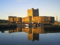
Carrickfergus Castle (from the Irish Carraig Ḟergus or "cairn of Fergus", the name "Fergus" meaning "strong man") is a Norman castle in Northern Ireland, situated in the town of Carrickfergus ![]() in County Antrim, on the northern shore of Belfast Lough. Besieged in turn by the Scottish, Irish, English and French, the castle played an important military role until 1928 and remains one of the best preserved medieval structures in Northern Ireland. It was strategically useful, with 3/4 of the castle perimeter surrounded by water (although in modern times only 1/3 is surrounded by water due to land reclamation).
in County Antrim, on the northern shore of Belfast Lough. Besieged in turn by the Scottish, Irish, English and French, the castle played an important military role until 1928 and remains one of the best preserved medieval structures in Northern Ireland. It was strategically useful, with 3/4 of the castle perimeter surrounded by water (although in modern times only 1/3 is surrounded by water due to land reclamation).
Carrickfergus was built by John de Courcy in 1177 as his headquarters, after he conquered eastern Ulster in 1177 and ruled as a petty king until 1204, when he was ousted by another Norman adventurer, Hugh de Lacy. Initially de Courcy built the inner ward, a small bailey at the end of the promontory with a high polygonal curtain wall and east gate. It had several buildings, including the great hall. From its strategic position on a rocky promontory, originally almost surrounded by sea, the castle commanded Carrickfergus Bay (later known as Belfast Lough), and the land approaches into the walled town that developed beneath its shadows.
Information about copyright | |
|---|---|
Rights characteristic / license | by-sa: CREATIVE COMMONS Attribution-ShareAlike |
Link to the description of the license | |
Input taken over from: |
Wikipedia contributors, 'Carrickfergus Castle', Wikipedia, The Free Encyclopedia, 31 December 2018, 22:59 UTC, <https://en.wikipedia.org/w/index.php?title=Carrickfergus_Castle&oldid=876222031> [accessed 15 January 2019] |
taken over / edited on | 15 Jan 2019
|
taken over / edited by |
|
61 km
0,2 km
11 m
Information about copyright | |
|---|---|
Rights owner | https://commons.wikimedia.org/w/index.php?title=User:GlenarmCastle |
Rights characteristic / license | by-sa: CREATIVE COMMONS Attribution-ShareAlike |
Link to the description of the license | |
Image taken over from | |
Image has been uploaded | by biroto-Redaktion on 15 Jan 2019
|
Information about copyright | |
|---|---|
Rights owner | |
Rights characteristic / license | by-sa: CREATIVE COMMONS Attribution-ShareAlike |
Link to the description of the license | |
Image taken over from | https://commons.wikimedia.org/wiki/File:Glenarm_Castle_-_geograph.org.uk_-_742685.jpg |
Image has been uploaded | by biroto-Redaktion on 15 Jan 2019
|
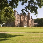
Glenarm Castle, Glenarm ![]() , County Antrim, Northern Ireland, is the ancestral home of the Earls of Antrim.
, County Antrim, Northern Ireland, is the ancestral home of the Earls of Antrim.
There has been a castle at Glenarm since the 13th century, where it resides at the heart of one of Northern Ireland ![]() 's oldest estates. It was owned by of John Bisset who acquired lands between Larne and Ballycastle from Hugh de Lacy, the Earl of Ulster. Bisset made Glenarm his capital, and by 1260 there was a castle, which stood at the centre of the present village, with a kitchen garden, an orchard and a mill, as well as woods and meadows. The old village courthouse still incorporates some of its walls, indeed an immured skeleton was discovered there in the 1970s. In 1495 Con O'Donnell of Tirconnell marched on ‘MacEoin of the Glens’ (as the Bisset chieftain was called), ‘for he had been told that MacEoin had the finest wife, steed and hound in his neighbourhood. O'Donnell had sent messengers for the steed but was refused it so he made no delay, but surmounting the difficulties of every passage he arrived at night at MacEoin's house without giving any warning of his designs. He captured MacEoin and made himself master of his wife his steed and his hound'. The last MacEoin Bisset was killed fighting the O'Donnells in 1522. Their lands were then seized by the MacDonnells, their former partners, who occupied the Bisset’s castle until they built the new one.
's oldest estates. It was owned by of John Bisset who acquired lands between Larne and Ballycastle from Hugh de Lacy, the Earl of Ulster. Bisset made Glenarm his capital, and by 1260 there was a castle, which stood at the centre of the present village, with a kitchen garden, an orchard and a mill, as well as woods and meadows. The old village courthouse still incorporates some of its walls, indeed an immured skeleton was discovered there in the 1970s. In 1495 Con O'Donnell of Tirconnell marched on ‘MacEoin of the Glens’ (as the Bisset chieftain was called), ‘for he had been told that MacEoin had the finest wife, steed and hound in his neighbourhood. O'Donnell had sent messengers for the steed but was refused it so he made no delay, but surmounting the difficulties of every passage he arrived at night at MacEoin's house without giving any warning of his designs. He captured MacEoin and made himself master of his wife his steed and his hound'. The last MacEoin Bisset was killed fighting the O'Donnells in 1522. Their lands were then seized by the MacDonnells, their former partners, who occupied the Bisset’s castle until they built the new one.
The present castle was built by Sir Randal MacDonnell, 1st Earl of Antrim, in 1636, and it has remained in the family since its construction. It is currently owned by Randal, Viscount Dunluce, the son of Alexander McDonnell, 9th Earl of Antrim. The McDonnells have been in Glenarm for nearly 600 years and the Estate has been in the family for 400 years.
Events
The Castle's Walled Garden is open to the public between May and September and hosts many events. In July of every year the grounds are the site of a world-class Highland Games. The Dalriada Festival is also held at Glenarm Castle and within the local village, which celebrates sport, music and fine food from all over Scotland and Ireland. The castle also hosts traditional Ulster Scots cultural events. As part of the Dalriada Festival, Glenarm Castle has started to host large outdoor concerts. As of 2012, it has welcomed artists like General Fiasco, The Priests, Duke Special, Ronan Keating, Sharon Corr, Brian Houston, David Phelps and the likes.
Summer Madness, Ireland's biggest Christian Festival, moved from its annual residence at the Kings Hall, Belfast, to Glenarm Castle in 2012. It is thought this festival will return to Glenarm on a yearly basis for the foreseeable future.
Information about copyright | |
|---|---|
Rights characteristic / license | by-sa: CREATIVE COMMONS Attribution-ShareAlike |
Link to the description of the license | |
Input taken over from: |
Wikipedia contributors, 'Glenarm Castle', Wikipedia, The Free Encyclopedia, 15 December 2018, 13:55 UTC, <https://en.wikipedia.org/w/index.php?title=Glenarm_Castle&oldid=873848868> [accessed 15 January 2019] |
taken over / edited on | 15 Jan 2019
|
taken over / edited by |
|
122 km
0,1 km
11 m
Information about copyright | |
|---|---|
Rights owner | |
Rights characteristic / license | by-sa: CREATIVE COMMONS Attribution-ShareAlike |
Link to the description of the license | |
Image taken over from | https://commons.wikimedia.org/wiki/File:Carrick-a-Rede_Bridge_-_geograph.org.uk_-_87464.jpg |
Image has been uploaded | by biroto-Redaktion on 15 Jan 2019
|
Information about copyright | |
|---|---|
Rights owner | https://commons.wikimedia.org/w/index.php?title=User:Hugo_van_dalen |
Rights characteristic / license | cc0: Public Domain no Rights reserved |
Link to the description of the license | |
Image taken over from | https://commons.wikimedia.org/wiki/File:Carrick_a_rede_2010.jpeg |
Image has been uploaded | by biroto-Redaktion on 15 Jan 2019
|
Information about copyright | |
|---|---|
Rights owner | |
Rights characteristic / license | by: CREATIVE COMMONS Attribution |
Link to the description of the license | |
Image taken over from | https://commons.wikimedia.org/wiki/File:Carrick-a-Rede_rope_bridge_20120623_143848.jpg |
Image has been uploaded | by biroto-Redaktion on 15 Jan 2019
|
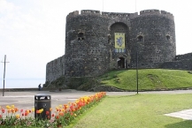
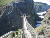
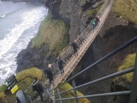
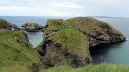
Carrick-a-Rede Rope Bridge (locally pronounced carrick-a-reedy) is a famous rope bridge near Ballintoy ![]() in County Antrim, Northern Ireland. The bridge links the mainland to the tiny island of Carrickarede (from Irish: Carraig a' Ráid, meaning "rock of the casting"). It spans 20 metres (66 ft) and is 30 metres (98 ft) above the rocks below. The bridge is mainly a tourist attraction and is owned and maintained by the National Trust. In 2009, it had 247,000 visitors. By 2016, that had increased to 440,000 visitors. The bridge is open all year round (subject to weather) and people may cross it for a fee.
in County Antrim, Northern Ireland. The bridge links the mainland to the tiny island of Carrickarede (from Irish: Carraig a' Ráid, meaning "rock of the casting"). It spans 20 metres (66 ft) and is 30 metres (98 ft) above the rocks below. The bridge is mainly a tourist attraction and is owned and maintained by the National Trust. In 2009, it had 247,000 visitors. By 2016, that had increased to 440,000 visitors. The bridge is open all year round (subject to weather) and people may cross it for a fee.
The area is exceptional in natural beauty with stunning views of Rathlin Island ![]() and Scotland. The site and surrounding area is designated an Area of Special Scientific Interest for its unique geology, flora, and fauna. Underneath there are large caves, which once served as home for boat builders and as shelter during stormy weathe
and Scotland. The site and surrounding area is designated an Area of Special Scientific Interest for its unique geology, flora, and fauna. Underneath there are large caves, which once served as home for boat builders and as shelter during stormy weathe
Information about copyright | |
|---|---|
Rights characteristic / license | by-sa: CREATIVE COMMONS Attribution-ShareAlike |
Link to the description of the license | |
Input taken over from: |
Wikipedia contributors, 'Carrick-a-Rede Rope Bridge', Wikipedia, The Free Encyclopedia, 26 December 2018, 20:19 UTC, https://en.wikipedia.org/w/index.php?title=Carrick-a-Rede_Rope_Bridge&oldid=875469658 [accessed 15 January 2019] |
taken over / edited on | 15 Jan 2019 - 04 Sep 2020
|
taken over / edited by |
|
135 km
0,8 km
0 m
Information about copyright | |
|---|---|
Rights owner | |
Rights characteristic / license | by: CREATIVE COMMONS Attribution |
Link to the description of the license | |
Image taken over from | https://commons.wikimedia.org/wiki/File:Giant's_Causeway_(14).JPG |
Image has been uploaded | by biroto-Redaktion on 15 Jan 2019
|
Information about copyright | |
|---|---|
Rights owner | |
Rights characteristic / license | by: CREATIVE COMMONS Attribution |
Link to the description of the license | |
Image taken over from | |
Image has been uploaded | by biroto-Redaktion on 15 Jan 2019
|
Information about copyright | |
|---|---|
Rights owner | |
Rights characteristic / license | cc0: Public Domain no Rights reserved |
Link to the description of the license | |
Image taken over from | https://commons.wikimedia.org/wiki/File:Antrim's_Causeway_contrasts.jpg |
Image has been uploaded | by biroto-Redaktion on 15 Jan 2019
|
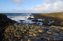
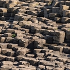
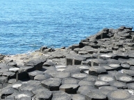
Giant's Causeway (Irish: Clochán an Aifir) is a spectacular rock formation on the Antrim coast of Northern Ireland. The site consists of some 40,000 basalt columns rising out of the sea. The Giant's Causeway is Northern Ireland's only UNESCO World Heritage Site.
Understand
Myth
Popular mythology attributes the creation of the Causeway to an Irish giant named Fionn mac Cumhaill. To prove his superior strength and status, Fionn decided to fight against a rival Scottish giant named Benandonner. As there was no boat large enough to carry huge Finn across the sea to confront Bennandonner, he built his own pathway of stepping stones from Ireland to Scotland. He then was able to walk across the sea without getting his feet wet.
When he crossed the sea, however, he saw just how large Benandonner was. He ran back to Ireland before Bennandonner saw him, but the causeway was built and Bennandonner came to fight. Fionn crawled into a crib and when Bennandonner came to the door to fight him, his wife told him not to wake the baby. Seeing just how large Fionn's "baby" was, Bennandonner grew afraid and ran back to Scotland, tearing up the causeway as he went to prevent Fionn following him.
Scientific explanation
The true explanation while not as colorful as the myths of yore is still quite interesting. Scientists now agree that about 60 million years ago a volcano let basalt come to or close to the surface that slowly cooled forming the polygon-shapes as the hot material contracted due to cooling. The hexagonal shape is most common as it is the most "efficient" way to "pack" material (just as it is in a beehive). Later erosion formed the current structure, as the basaltic material forming the pillars is more resistant to erosion than other material. Similar structures (though in less impressive locations) can be found throughout the world.
See
The focal point of the area is, of course, the Giant's Causeway. There is no charge for visiting the causeway.
It is an interesting site to see but come prepared for a long and intense walk. Best to wear waterproof clothing and strong footwear. Giant's Causeway is split up into six sections; in walking order:
- The Camel.
- The Granny.
- The Wishing Chair.
- The Chimney Tops.
- The Giant's Boot.
- The Organ.
All six parts of the Giant's Causeway are different in shape and form and truly are a sight to be seen.
Information about copyright | |
|---|---|
Rights characteristic / license | by-sa: CREATIVE COMMONS Attribution-ShareAlike |
Link to the description of the license | |
Input taken over from: |
Wikivoyage contributors, 'Giant's Causeway', Wikivoyage, The FREE worldwide travel guide that anyone can edit, 27 December 2018, 02:31 UTC, <https://en.wikivoyage.org/w/index.php?title=Giant%27s_Causeway&oldid=3678822> [accessed 15 January 2019] |
taken over / edited on | 15 Jan 2019
|
taken over / edited by |
|
![]()