
Cycle Tour Tour in the Alps 2013
Dag 11: Lechleiten - Bregenz
![]()
Please wait - map data are loading
Added on 25 Aug 2013
last edited by Ottocolor on 31 Aug 2020
Cycle route metrics
ridden
Total distance in km
89
Cumulative elevation gain in m
1.479
Avg. slope uphill in %
1,66
Cumulative elevation loss in m
2.626
Min. height
394
Max. height
1.672
Information about rights to the gps-track data | |
|---|---|
Rights owner | |
Rights characteristic / license | by-sa: CREATIVE COMMONS Attribution-ShareAlike |
Link to the description of the license | |
GPX file uploaded | by Ottocolor on 18 Nov 2013
|
Track points in total
1.409
Track points per km (avg)
16
Start/endpoint
Start location
Steeg, Tirol, AT (1536 m NHN)
End location
Bregenz, Vorarlberg, AT (396 m NHN)
ridden on
09 Aug 2013
Weather
Rain all the day and cool. In the evening dry weather. No wind of any significance
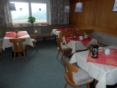
Accommodation
Seecamping Bregenz
Hechtweg 1
AT-6900 Bregenz
Properties
Mountain road up to Hochtannbergpass and steeply downwards on the other side. Sligthly slippery in the rain. On the road until Schoppernau, then a bike route on minor roads and cycle lanes along the main road. Very good signposting. After the town of Egg again on a busy road uphill to Alberschwende. From there on a minor road down to Haselgehr. Here began an excellent bike path along the railway to Lauterach. From here on a bike lane through the town. In the end a gravel path along the river of Bregenzer Ach to the camping ground of Bregenz.
Sources of information
Kompass cycling- and mountainbikemap no. 3126 Bregenzerwald Vorarlberg Oberstdorf 1:70,000
Remarks
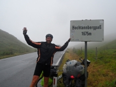
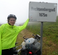
The cycle holiday's last real bike stage over the cycling summit of 1,675 m and down to Lake Constance, unfortunately ridden in rain all day.
Travel report
Information about copyright | |
|---|---|
Rights owner | |
Rights characteristic / license | by-sa: CREATIVE COMMONS Attribution-ShareAlike |
Link to the description of the license | |
Image has been uploaded | by Ottocolor on 05 Dec 2013
|
Information about copyright | |
|---|---|
Rights owner | |
Rights characteristic / license | by-sa: CREATIVE COMMONS Attribution-ShareAlike |
Link to the description of the license | |
Image has been uploaded | by Ottocolor on 05 Dec 2013
|
Information about copyright | |
|---|---|
Rights owner | |
Rights characteristic / license | by-sa: CREATIVE COMMONS Attribution-ShareAlike |
Link to the description of the license | |
Image has been uploaded | by Ottocolor on 05 Dec 2013
|
Today the roof of the Alpine tour was on the program. Fortunately, we had gone so much uphill the last days that we did not miss a lot of height, but then a lot of downhill cycling afterwards. But unfortunately the rain splashed down from the morning, when I opened the curtain aside. the alpine panorama was completely hidden in clouds and fog. Aw, we had not seen this coming after one and a half week in lovely sunshine. The last rain we had experienced on the first day in Munich. And it remained the only wet day, on the other hand it kept raining mercilessly. It meant that we were more interested in reaching the campsite in Bregenz. Yet you can still enjoy such a day in a special way, because you think about yourself it's well done, you keep on whatever the weather. And after arriving, showering and eating you have a fantastic time. The reward is somewhat bigger after cycling in the rain. Well, to the details.
After the lovely breakfast where we were pitied a great deal because of the weather, the stage length of a little less than 90 km plus of course the ascent to the pass, we packed everything together in our room downstairs. Unfortunately I forgot my König Ludwig-flag, which I had put on the mirror over the desk. We said goodbye to our wonderful mountain pension and the hearty Frau Lechleitner. It looked very traditional also from the outside, except for the large solar panels on the two balconies. In a way, marring the facade a little, but it is a sound investment for the owners. The first piece of the stage, I knew very well, for it led to Warth, where I of course had been yesterday. The difference was that now the bike was heavy loaded and I could feel that in the two hairpin bends up to the city. As usual, Simon sped ahead. He said he had good legs today. But he was nice to his father and held back a little in between. Through the town the road went only a bit upwards and through a long avalanche gallery. We could not see much from in there, but that didn't improved even when it finally ended. Up here we cycled completely inside the rain clouds. And all the power went to trample the bike instead. I knew exactly how far it was up to the col at 1,675 m And I knew there was a sign that said Hochtannbergpass and the height. I had to struggle a good deal to see it with a few breaks to blow out in. But then I saw Simon in his bright yellow raincoat standing leaning against it, and then I was thrilled. It was after all what we had fought for and we felt like true mountain kings. But now it was about to get some more clothes on, for from now, we would go downhill. There are two large car parks for the many cars that normally enjoy the heights up here. There are no trees up here, as it is above the tree line. That was all we could see. All the stunning mountain scenery was completely hidden for us. I had seen so beautiful pictures on the internet. But now we thought more about getting some clothes on to get some warmth and then just make it back to the valley again, where it was a little warmer. Up here it was just bitterly cold.
Information about copyright | |
|---|---|
Rights characteristic / license | by-sa: CREATIVE COMMONS Attribution-ShareAlike |
Link to the description of the license | |
taken over / edited on | 04 Feb 2014
|
taken over / edited by |
|
Information about copyright | |
|---|---|
Rights owner | |
Rights characteristic / license | by-sa: CREATIVE COMMONS Attribution-ShareAlike |
Link to the description of the license | |
Image has been uploaded | by Ottocolor on 05 Dec 2013
|
Information about copyright | |
|---|---|
Rights owner | |
Rights characteristic / license | by-sa: CREATIVE COMMONS Attribution-ShareAlike |
Link to the description of the license | |
Image has been uploaded | by Ottocolor on 05 Dec 2013
|
Information about copyright | |
|---|---|
Rights owner | |
Rights characteristic / license | by-sa: CREATIVE COMMONS Attribution-ShareAlike |
Link to the description of the license | |
Image has been uploaded | by Ottocolor on 05 Dec 2013
|
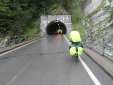
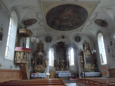
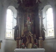
The first hairpin bends down the hill were very steep and narrow. We had agreed to take it easy, especially in the corners. With the heavy luggage on our bikes on the rainy road we were a little afraid of slipping, and to one side it was really a long fall down in some places. But there were guardrails all the way down, and because of the weather there was almost no traffic. This road is otherwise very popular among motorcyclists because of the many turns and great views. In Grainau we'd been talking to a German, who had a book about famous Alpine passes for motorcyclists where the Hochtannbergpass also featured. I had been looking forward to this descent, but with the rain lashing the face and the cold fingers desperately clasping both brake levers it was now no pleasure. Now we enjoyed it most in the many short tunnels we drove through. Dry weather! The winter sports resort of Schröcken we whizzed through and stopped first at the bottom to take some of our clothes off again. Now, we followed the river Bregenzer Ach, which followed us most of the day all the way to its mouth in Lake Constance near Bregenz. It was nice for once to go with the flow. Soon we were in the cozy mountain village of Schoppernau, and here we wanted to find a place to eat our packed lunch. I suggested the church, which stood somewhat off the main road. There were many hotels and restaurants, but today they all seemed deserted. I suggested to go into the porch, but there was only a flight of stairs to the church, we could sit on. Simon did not like my idea. If someone came to prayers, they might take offense at our presence. And we dripped on the floor, wet as we were. Instead we looked into the church, however, to play around like tourists when we were here. But it was cold in there, and we froze in our wet clothes so we were quickly out again. In the chapel next to lay a coffin, so we were probably not welcome there either. One of the town's citizens had died the previous day, it said in a notice beside it. Instead, we found a restaurant nearby. I suggested we went in there and asked if we could eat our lunch there and buy some drinks. Simon was in for that, and we jolly well allowed to do so. I had not really expected that from the stiff Austrians, but we probably looked like a couple of cyclists, who fancied some warmth and a break in dry environment. There was also plenty of room in there. Only the window seats were occupied, so I chose a table near the door to us. It was nice to relax a bit and look out and hope it soon stopped raining.
But no such luck, so it was a clammy feeling to put the wet rain gear on again, but luckily we still went down, and we trampled our pedals well to get warmt into our bodies again. When you have been warmed up inside, you will quickly feel cold afterwards in wet clothes. But we rode on, but it was still far to go, so there was nothing else to do. Fortunately a good bike route on small roads along the main road now began, where there was more traffic now. When I suggested to drive on the main road, Simon thought it was too dangerous, and signs on the route were so accurate that it was easy to follow. First, we followed the signs to Schnepfau, then to Mellau. In Mellau we supplied ourselves on cakes for our coffee/tea break. I could see on my map there was a campsite a little further along. Maybe we could be allowed to make coffee there and enjoy ourselves a little in the common room. Outside the grocery store we fell into conversation with a German guy who was a regular guest here in Bregenzerwald, as the area is called. Later we met him again at the campsite, where he offered to boil water for coffee and tea for us. And we were allowed to sit in the TV room, because it was still raining in torrents. The German said it was only 25 km from Mellau to Bregenz, which I did not check, but took at face value. Then we had time. But there were actually 43 km on our route, which was probably a little longer than the quickest route for cars, but not 18 km! Well, we had good legs and just continued on the route as planned. Although there were slight increases in between now. And shortly after the campsite my bike computer broke down. It was probably tired of all the rain and stopped working. Aw, now I could not keep track of how far we cycled. But Simon's still worked, and he took over the management of our mileage. And then we could quickly see that it was longer to Bregenz than we thought.
The map showed that our planned route made a proper detour via Andelsbuch and Egg, while there was a shorter way to the left. Maybe this was the way the German guy had meant, but I dropped quickly as an option because my map was luckily equipped with contour lines, and they were very close to each other, so the shortcut meant a serious climb. We'd rather ride a little longer and be a little more wet. If we could become so. But the route was still beautiful along paved bike paths in a steady decline, so it felt okay. Until we hit the town of Egg. Here the bike trail suddenly ended and we continued in the afternoon rush hour traffic up a long, long climb. It was not so nice to leave the river and stomp up a long hill, where we were constantly pushed to the side by the cars. Shortly before Alberschwende the increase was finally over. It was not especially steep, but just long and tiresome. Inside Alberschwende we left the roaring traffic on the main road and rolled down for almost ten kilometres down to Haselstauden. The last piece was wildly steep. It was almost like falling off a mountain. It stopped right at a busy crossroads with red traffic lights, so thanks for brakes that worked here. When it turned green, I saw a lady and asked her if we were heading towards the train station and it was absolutely correct. Here I knew that the bike path along the railway led into Bregenz, and it was again a pleasure to ride along. Had we not been so tired now and really looked forward to arrive at the campsite. After a short stop at a petrol station in Lauterach to counteract a beginning feeling of going sugar cold with me, we reached the river Bregenzer Ach again, and here we turned down a dirt road along the river to the great surprise of Simon, who did not believe it could be right. But the river ran out to the lake where the campsite was, so it had to be right. After a while on the path I was persuaded to leave it, but then we had to look for the campsite as there were two, namely Mexico Camping and Lake Camping. I chose the latter, where we were assigned a very cramped space all the way down in a corner of a forest. There was just room for our tent.
The first plank here was a nice long hot bath. As if we were not wet enough today. But it did really well. At the same time I threw all our wet clothes into the dryer standing near the bathhouse. Now we were quite hungry. At the same time we would like to see the Bundesliga match between Bayern Munich and Borussia Monchengladbach, so if we were lucky, we found a restaurant in town where they transmitted football. First we had to ride the 3-4 km into the center of Bregenz. Fortunately, the rain had finally stopped so we stayed dry.
The path led along the banks of Lake Constance, where the campsite also was, right down the past several large marinas and the famous Lake Scene which we would look at in the morning, into the center. It seemed like a nice town with big mansions and chique shops. A casino we spotted too. A really posh city for the rich. But Simon and I did not look for anything else than the two things we were craved for. A passerby informed os that at Sport-Wetten, a betting agency around, they transmitted football matches. And we arrived just in time for the kick off. Bayern played well and quickly went ahead 2-0. I did play on the result of the match, so we had a reason to be there. And asked if we were allowed to get some take-away food. That was all right and in the halftime break we found a turkish barbecue and each ordered a large Döner kebab. With lots of dressing and a beer and a coke. With that in hand we returned to Sport- Wetten and ate and drank and wathced football on TV. NOW we felt perfect. Bayern went on to win 3-1 after making an own goal, but it was the result I had bet on, so the evening could not have ended better. Now it was just back to the Lake Camping, drag the clothes out of the dryer and go to bed as soon as possible.
Information about copyright | |
|---|---|
Rights characteristic / license | by-sa: CREATIVE COMMONS Attribution-ShareAlike |
Link to the description of the license | |
taken over / edited on | 06 Feb 2014
|
taken over / edited by |
|