
Cycle Tour Von Erfurt nach Venedig
Planned tour
Actions
![]()
Please wait - map data are loading
Added on 02 Feb 2019,
last edited by Spitze93 on 02 Feb 2019
Actions
Cycle route metrics
planned
ridden
Total distance in km
917
0
Cumulative elevation gain in m
6.818
0
Avg. slope uphill in %
0,74
-
Cumulative elevation loss in m
7.010
0
Information about rights to the gps-track data | |
|---|---|
Rights owner | |
Rights characteristic / license | cc0: Public Domain no Rights reserved |
Link to the description of the license | |
GPX file uploaded | by Spitze93 on 02 Feb 2019
|
Track points in total
14.250
0
Track points per km (avg)
16
0
Start/endpoint
Start location
Erfurt, Thüringen, DE (196 m NHN)
End location
Caorle, Veneto, IT (4 m NHN)
Character
Information about copyright | |
|---|---|
Rights characteristic / license | by-sa: CREATIVE COMMONS Attribution-ShareAlike |
Link to the description of the license | |
taken over / edited on | 02 Feb 2019
|
taken over / edited by |
|
Landscape
Information about copyright | |
|---|---|
Rights characteristic / license | by-sa: CREATIVE COMMONS Attribution-ShareAlike |
Link to the description of the license | |
taken over / edited on | 02 Feb 2019
|
taken over / edited by |
|
Beds4Cyclists, worth visiting and infrastructure
Name and address
Latitude / Longitude
Phone
Fax
Mobile
Type of accommodation
Rating for cyclists
Route km
Dist. to route
Elevation
0 km
0,0 km
195 m
Information about copyright | |
|---|---|
Rights owner | |
Rights characteristic / license | cc0: Public Domain no Rights reserved |
Link to the description of the license | |
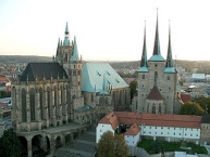
Image taken over from | commons.wikimedia.org/wiki/File:Erfurt_cathedral_and_severi_church.jpg |
Image has been uploaded | by biroto-Redaktion on 16 Mar 2013
|
Information about copyright | |
|---|---|
Rights owner | |
Rights characteristic / license | by-sa: CREATIVE COMMONS Attribution-ShareAlike |
Link to the description of the license | |
Image taken over from | |
Image has been uploaded | by biroto-Redaktion on 16 Mar 2013
|
Information about copyright | |
|---|---|
Rights owner | |
Rights characteristic / license | by-sa: CREATIVE COMMONS Attribution-ShareAlike |
Link to the description of the license | |
Image taken over from | commons.wikimedia.org/wiki/File:Haus_zum_Breiten_Herd_Gildehaus_Erfurt.jpg |
Image has been uploaded | by biroto-Redaktion on 16 Mar 2013
|
Information about copyright | |
|---|---|
Rights owner | |
Rights characteristic / license | by-sa: CREATIVE COMMONS Attribution-ShareAlike |
Link to the description of the license | |
Image taken over from | commons.wikimedia.org/wiki/File:Landtagprojekt_Thueringen_Erfurt_2011_(RaBoe)_104.jpg |
Image has been uploaded | by biroto-Redaktion on 16 Mar 2013
|
Erfurt (German pronunciation: [ˈɛʁfʊʁt]) is the capital city of Thuringia and the main city nearest to the geographical centre of modern Germany. Together with neighboring cities Weimar ![]() and Jena
and Jena ![]() it forms the central metropolitan area of Thuringia with approximately 500,000 inhabitants. Notable institutions in Erfurt are the Federal Labour Court of Germany
it forms the central metropolitan area of Thuringia with approximately 500,000 inhabitants. Notable institutions in Erfurt are the Federal Labour Court of Germany ![]() , the University of Erfurt
, the University of Erfurt ![]() and the Fachhochschule
and the Fachhochschule ![]() Erfurt as well as the Roman Catholic Diocese of Erfurt with Erfurt Cathedral
Erfurt as well as the Roman Catholic Diocese of Erfurt with Erfurt Cathedral ![]() as one of the main sights.
as one of the main sights.
Erfurt was first mentioned in 742, as Saint Boniface founded the diocese. Although the town did not belong to one of the Thuringian states politically, it quickly became the economic centre of the region. Until the Napoleonic era it was part of the Electorate of Mainz and afterwards it belonged to Prussia until 1945. The university was founded in 1392, closed in 1816 and reestablished after German reunification in 1994. It is one of the oldest universities in Germany. Martin Luther was the most famous student of the institution.
Cityscape
Erfurt's cityscape features a medieval core of narrow, curved alleys in the centre surrounded by a belt of Gründerzeit architecture, created between 1873 and 1914. In 1873, the city's fortifications were demolished and it became possible to build houses in the area in front of the former city walls. In the following years, Erfurt saw a construction boom. In the northern area (districts Andreasvorstadt, Johannesvorstadt and Ilversgehofen) tenements for the factory workers were built whilst the eastern area (Krämpfervorstadt and Daberstedt) featured apartments for white-collar workers and clerks and the southwestern part (Löbervorstadt and Brühlervorstadt) with its beautiful valley landscape saw the construction of villas and mansions of rich factory owners and notables. During the interwar period, some settlements in Bauhaus style were realized, often as housing cooperatives. After World War II and over the whole GDR period, housing shortages remained a problem even though the government started a big apartment construction programme. Between 1970 and 1990 large Plattenbau settlements with high-rise blocks on the northern (for 50,000 inhabitants) and southeastern (for 40,000 inhabitants) periphery were constructed. After reunification the renovation of old houses in city centre and the Gründerzeit areas was a big issue. The federal government granted substantial subsidies, so that many houses could be restored.
Compared to many other German cities, little of Erfurt was destroyed in World War II. This is one reason why the centre today offers a mixture of medieval, Baroque and Neoclassical architecture as well as buildings from the last 150 years. Public green spaces are located along Gera river and in several parks like the Stadtpark, the Nordpark and the Südpark. The largest green area is the egapark (de ![]() ), a horticultural exhibition park and botanic garden established in 1961.
), a horticultural exhibition park and botanic garden established in 1961.
Sights and architectural heritage
Churches, monasteries and synagogues
The city centre hosts about 25 churches and monasteries, most of them in Gothic style, some also in Romanesque style or a mixture of Romanesque and Gothic elements, and a few in later styles. The various steeples characterize the medieval centre and led to one of Erfurt's nicknames as the "Thuringian Rome".
Catholic churches and monasteries:
- The Allerheiligenkirche (All Saints Church) is a 14th-century Gothic parish church at Market Street, which hosts a Columbarium.
- The Dom St. Marien (St Mary's Cathedral
 ) is the largest church in Erfurt on Domberg hill near the Dom Square. It combines Romanesque and Gothic elements and hosts one of the largest medieval bells, the Gloriosa. It is also the Episcopal see and one of the main sights of Erfurt.
 - The Lorenzkirche (St Laurence's Church) is a small 14th-century Gothic parish church at Anger Square.
- The Martinikirche (St Martin's Church) was built in the 15th century in Gothic style and later converted to Baroque style. It was both a Cistercian monastery and a parish church of Brühl, a medieval suburban zone.
- The Neuwerkskirche St. Crucis (New plant church/Holy Cross Church) is a 15th-century Gothic parish church at Neuwerk Street, that was later converted to Baroque style. Until 1285, it was used as an Augustinian monastery.
- The Schottenkirche St. Nikolai und St. Jakobi (Scots Monks' Church St Nicholas and St James) is an 11th-century Romanesque monastery church with a Baroque façade, which was later used as a parish church.
- The Severikirche (St Severus' Church) is the second-largest parish church after the cathedral and stands next to it on the Domberg hill. It is a Gothic church and was built around 1300.
- The Ursulinenkirche (Ursulines Church) is a Gothic monastery church at Anger Square. It is attached to the only monastery still in operation in Erfurt.
- The Wigbertikirche (St Wigbert's Church) is a 15th-century Gothic parish church at Anger Square.
Protestant churches and monasteries:
- The Ägidienkirche (St Giles' Church) is a 14th-century Gothic parish church at Wenigenmarkt Square. It is the surviving one one of formerly two bridge-head churches of Krämerbrücke located on both ends of the bridge. As a result, the hall is on the 1st floor, while on ground level is a passage to the bridge. The steeple is open to the public and offers a good view over the city centre. Today, St Giles' Church is a Methodist parish church.
- The Andreaskirche (St Andrew's Church) is a 14th-century Gothic parish church at Andrew's Street. The old craftsmen's quarter around it is named Andreasviertel after the church.
- The Augustinerkirche (St Augustine's Church) is a 14th-century Gothic monastery church at Augustine's Street. Martin Luther lived here as a monk between 1505 and 1512. Today, the church and the monastery are owned by the Protestant church, which uses them as a conference and education centre.
- The Kaufmannskirche St. Gregor (Merchant's Church St Gregory) is a 14th-century Gothic parish church at Anger Square. It is one of the largest and most important original parish churches in Erfurt.
- The Michaeliskirche (St Michael's Church) is a 13th-century Gothic parish church at Michael's Street. It became the church of the university in 1392.
- The Predigerkirche (Preacher's Church) is a 14th-century Gothic monastery church of the Dominicans at Preacher's Street. Since the Reformation in the 16th century, it is the main Protestant church of Erfurt and furthermore one of the largest former mendicant orders churches in Germany.
- The Reglerkirche St. Augustinus(Regulated St Augustine's Church) is a 12th-century Romanesque-Gothic monastery church of the Augustinians at Station Street. After the Reformation, it became a Protestant parish church
Street and square ensembles:
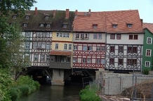
- The Krämerbrücke (Monger's Bridge) is the most famous tourist attraction of Erfurt. This 15th-century bridge is completely covered with dwellings and unique in Europe north of the Alps. Today, there are some art handicraft and souvenir shops in the houses.
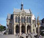
- The Domplatz (Cathedral Square) is the largest square in Erfurt and one of the largest historical market squares in Germany. The cathedral and St Severus' Church on its western side can be reached over the Domstufen, a wide flight of stairs. On the north side lies the courthouse, a historicist building from 1880. The eastern and southern side is fronted by early-modern patrician houses. On the square are the Minerva Fountain from 1784 and the Erthal Obelisk from 1777. The Domplatz is the main setting of the Erfurt Christmas Market in December and the location for "DomStufen-Festival", an open-air theatre festival in summer.
- The Fischmarkt (Fish Market) is the central square of Erfurt's city centre. It is belted by renaissance-style patrician houses and the town hall, a neo-gothic building from 1882. In the middle of the square is a statue called "Römer" (Roman), a symbol of the city's independence, erected by the citizens in 1591.
- The Wenigemarkt (Minor Market) is a small square on the east side of the Gera river (opposite to the Fischmarkt on the west side), belted by early-modern patrician and merchants' houses. The fountain on this square with the sculpture "Scruffling Boys" was created in 1975. Today, Wenigemarkt square also sports various cafes and bars. Next to the Wenigemarkt in Futterstraße is the Kaisersaal building, a neoclassicistic event hall from 1831 (current building). The Congress of Erfurt took place here in 1808.
- The Anger (originally the German term for "village green") is a protracted square in the eastern city centre. All tram lines are linked here, so that it became the new city centre during the 20th century with many important buildings. On its northern side is the main post office, built in 1886 in neo-gothic style with its prominent clock tower. In the north-east there is the Martin Luther monument from 1889 in front of the Merchant's Church. Between the church and the Ursuline monastery lies the "Anger 1" department store from 1908. On the south side next to Station Street is the Angermuseum, the art history museum of Erfurt inside a Baroque palace from 1711. The western part of Anger square is belted by large historicist business houses from the late 19th century. The west end of the square is marked by the Angerbrunnen fountain from 1890. The Jesuit's College near Schlösserstraße was built in 1737 and used until the ban of the Jesuits in 1773.
- The Willy Brandt Square is the southern gate to the city centre in front of the main station. Opposite to the station is the former hotel Erfurter Hof, where the first meeting of the East- and West-German heads of government took place in 1970. On the western side is the building of the old Erfurt station (1847–1895) with a clock tower and the former offices of the Thuringian Railway Company.
- The Hirschgarten (Deer Garden) is a small park in front of the Thuringian government seat in the western city centre. The minister-president's seat is the Kurmainzische Statthalterei, a Renaissance-Baroque palace from the 17th century.
- The Michaelisstraße (Michael's Street) is known as "the lithic chronicle of Erfurt", because of its mostly medieval buildings. It is the main street of the Latin quarter around the old university and today one of the favorite nightlife districts of the Erfurtians with various bars, restaurants and cafes. The central building of the old university, Collegium Maius, was built in 1515, destroyed by Allied bombs in 1945 and originally rebuilt in 1999.
- The Juri-Gagarin-Ring is an inner-city circular road following the former inner city wall. The road was set out in the 1890s by closing a branch of the Gera river. The buildings along the street originate from all periods of the 20th century, including some GDR-era highrise residence buildings. An old building complex here is the former Great Hospital, established in the 14th century. Today, it hosts the museum of popular art and cultural anthropology.
- The Andreasviertel (St Andrew's Quarter) is a small quarter in the northern part of the city centre between Domplatz in the south-west and Moritzwallstraße in the north-east. It was the former craftsmen quarter with narrow alleys and old (16th/17th century) little houses. During the 20th century, there were plans to demolish the quarter because of its bad housing conditions. After 1990, the houses were redeveloped by private individuals so that it is one of the favourite neighbourhoods today. The largest building here is the former Municipal Corn Storage in Gothic style from 1466 with a floor area of 1,800 m2 (19,375 sq ft).
Fortifications:
Fortifications played an important role during Erfurt's history. Nevertheless, the city wall was broken down in 1873. There are only rare artefacts of the walls today, for example the Johannesmauer near Franckestraße in the north-east of the city centre. More important are the two early-modern citadels of Erfurt, which remain more or less in their original state.
The Petersberg Citadel is one of the largest extant early-modern citadels in Europe and covers the whole north-western part of the city centre. It was built after 1665 on Petersberg hill and was in military use until 1963. Since 1990, it has been renovated, but in parts is still not finished yet.
The Cyriaksburg Citadel is a smaller early-modern citadel south-west of the city centre, built during the Thirty Years' War. Today, it hosts the German horticultural museum.
Information about copyright | |
|---|---|
Rights characteristic / license | by-sa: CREATIVE COMMONS Attribution-ShareAlike |
Link to the description of the license | |
Input taken over from: |
Wikipedia contributors, 'Erfurt', Wikipedia, The Free Encyclopedia, 12 September 2014, 20:57 UTC, http://en.wikipedia.org/w/index.php?title=Erfurt&oldid=625289170 |
taken over / edited on | 18 Sep 2014 - 10 Jun 2021
|
taken over / edited by |
|
0 km
0,1 km
194 m
Hours of opening
Montag - Samstag 10.00 - 18.00 Uhr
0 km
0,4 km
188 m
1 km
3,8 km
215 m
1 km
0,9 km
205 m
![]()