Radtour Durch die Camargue
Reisebericht: Rundtour durchs Rhône Delta
Aktionen
![]()
Bitte warten - Kartendaten werden geladen
Erstellt am 08.10.2017,
zuletzt geändert von Tandemteam-Traudel_und_Dieter am 09.10.2017
Aktionen
Strecken-Merkmale
geplant
gefahren
Gesamtlänge in km
89
92
Gesamthöhenmeter Aufstieg
153
101
Durchschn. Steigung Aufstieg %
0,17
0,11
Gesamthöhenmeter Abstieg
153
97
Gesamtsattelstunden
-
6,1
Durchschnittsgeschwindigkeit in km/Std.
-
15,1
Informationen zu Rechten an den GPS-Track-Daten | |
|---|---|
Rechte-Inhaber | |
Rechte-Ausprägung / Lizenz | by-sa: CREATIVE COMMONS Namensnennung, Weitergabe unter gleichen Bedingungen |
Link zur Rechtebeschreibung | |
gpx-Datei hochgeladen | durch Tandemteam-Traudel_und_Dieter am 08.10.2017
|
Gesamtzahl Trackpoints
336
881
Trackpoint-Dichte per km
4
10
Endorte
Start
Saintes-Maries-de-la-Mer, Provence-Alpes-Côte d'Azur, FR (2 m NHN)
Ziel
Saintes-Maries-de-la-Mer, Provence-Alpes-Côte d'Azur, FR (2 m NHN)
Charakter
Informationen zu Urheber-Rechten | |
|---|---|
Rechte-Ausprägung / Lizenz | by-sa: CREATIVE COMMONS Namensnennung, Weitergabe unter gleichen Bedingungen |
Link zur Rechtebeschreibung | |
übernommen / bearbeitet am | 08.10.2017 - 09.10.2017
|
übernommen / bearbeitet durch |
|
Landschaft
Informationen zu Urheber-Rechten | |
|---|---|
Rechte-Ausprägung / Lizenz | by-sa: CREATIVE COMMONS Namensnennung, Weitergabe unter gleichen Bedingungen |
Link zur Rechtebeschreibung | |
übernommen / bearbeitet am | 08.10.2017
|
übernommen / bearbeitet durch |
|
An- und Abreise
Mit Auto zum Campingplatz in Saintes-Maries-de-la-Mer.
In Frankreich ist es nicht erlaubt, ein Tandem im Zug mitzunehmen!
Etappen
Informationen zu Urheber-Rechten | |
|---|---|
Rechte-Inhaber | |
Rechte-Ausprägung / Lizenz | © Alle Rechte vorbehalten. |
Bild hochgeladen | durch Tandemteam-Traudel_und_Dieter am 09.10.2017
|
92 km
Saintes-Maries-de-la-Mer
Fahrradfreundliche Unterkünfte, Sehenswertes und Infrastruktur
Name u. Anschrift
Breite / Länge
Tel.
Fax.
Mobile
Art d. Unterkunft
Radler-freund-lichkeit
Strecken-km
km zur Strecke
Höhe
0 km
3,6 km
4 m
2 km
0,0 km
2 m
FR-13460 Saintes-Maries de la Mer
Touristen Information
Öffnungszeiten
- January - February - March – November - December: from 9:00 am to 5:00 pm
- October: from 9:00 am to 6:00 pm
- April - May - June - September: from 9:00 am to 7:00 pm
- July and August: from 9:00 a.m. to 8:00 p.m.
36 km
0,3 km
6 m
64 km
4,2 km
10 m
Informationen zu Urheber-Rechten | |
|---|---|
Rechte-Inhaber | Parc naturel régional de Camargue, Arles, FR |
Rechte-Ausprägung / Lizenz | © Alle Rechte vorbehalten. |
Bild hochgeladen | durch biroto-Redaktion am 15.02.2015
|
Informationen zu Urheber-Rechten | |
|---|---|
Rechte-Inhaber | |
Rechte-Ausprägung / Lizenz | by-sa: CREATIVE COMMONS Namensnennung, Weitergabe unter gleichen Bedingungen |
Link zur Rechtebeschreibung | |
Bild übernommen aus | https://commons.wikimedia.org/wiki/File:Camargue_Pferde_2.JPG |
Bild hochgeladen | durch biroto-Redaktion am 15.02.2015
|
Informationen zu Urheber-Rechten | |
|---|---|
Rechte-Inhaber | |
Rechte-Ausprägung / Lizenz | by: CREATIVE COMMONS Namensnennung |
Link zur Rechtebeschreibung | |
Bild übernommen aus | https://commons.wikimedia.org/wiki/File:Phoenicopterus_roseus_Camargue_4.jpg |
Bild hochgeladen | durch biroto-Redaktion am 15.02.2015
|
Informationen zu Urheber-Rechten | |
|---|---|
Rechte-Inhaber | |
Rechte-Ausprägung / Lizenz | by-sa: CREATIVE COMMONS Namensnennung, Weitergabe unter gleichen Bedingungen |
Link zur Rechtebeschreibung | |
Bild übernommen aus | https://commons.wikimedia.org/wiki/File:Salin_du_Midi_10.jpg |
Bild hochgeladen | durch biroto-Redaktion am 15.02.2015
|
Der Regionale Naturpark Camargue (französisch Parc naturel régional de Camargue) erstreckt sich im französischen Département Bouches-du-Rhône, in der Region Provence-Alpes-Côte d’Azur. Er liegt in der gleichnamigen Landschaft Camargue , im Mündungsdelta der Rhône. Das Gebiet erstreckt sich grob zwischen den Mündungsarmen Grand Rhône
und Petit Rhône
und umfasst somit die Grande Camargue
, im Südwesten aber auch noch Teile der Petite Camargue
.
Der Naturpark wurde 1970 gegründet und umfasst eine Fläche von 86.000 Hektar. Der Bereich ist mit rund 7200 Einwohnern nur sehr schwach besiedelt.
Vor der Küstenlinie befindet sich noch ein 3 Meilen breiter Meeresstreifen, der ebenfalls dem Naturpark zugeordnet ist.
Der Naturpark besteht aus rund 55 % Naturlandschaft und gliedert sich in folgende Bereiche:
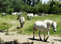
- Die Obere Camargue (westlich und südlich der Stadt Arles) wird hauptsächlich landwirtschaftlich genutzt, wobei der Anbau von Feldfrüchten, darunter auch Reis und die Viehzucht (Camargue-Pferd
und Camargue-Rind) hervorzuheben sind.
- Die Mittlere Camargue wird im Zentrum vom Naturreservat rund um den Brackwasser-See Étang de Vaccarès
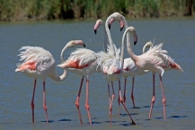
geprägt, der für seine reiche Population an Wasservögel bekannt ist. Besonders der Rosaflamingo ist zu einem Markenzeichen des Naturparks geworden. Ansonsten dominieren Feuchtzonen mit Schilfgebieten und Strandflieder.
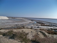
- Die Untere Camargue wird von Sandstränden und Salzwasser-Lagunen bestimmt, im Südosten wird das Salz in der Salin-de-Giraud
wirtschaftlich gewonnen.
Sehenswürdigkeiten
- ⊙Musée de la Camargue am Mas du Pont de Rousty an der Straße (D 570) von Arles
 nach Les Saintes-Maries-de-la-Mer
  , informiert über die Camargue, ihre Bewohner und das traditionelle Handwerk (Arbeit der Gardians (Viehhüter) auf den Mas (Landwirtschaftsgütern)).
 - ⊙Musée du Riz an der Straße D36 Richtung Salin-de-Giraud: Informationen zum Reisanbau in der Camargue.
- ⊙Mas de la Capelière, Mas de la Capelière. 09.00-13.00/14.00-18.00 (Winter -17.00h, Di geschlossen. 3.00/1.50 €, Gruppen auf Voranmeldung: Informationen zu Vogelwelt und Entdeckungspfade mit Vogelbeobachtungshäuschen, für Gruppen werden auf Anmeldungen Führungen angeboten.
- Salin de Badon 3.00/1.50 €: Erlebnispfade mit Möglichkeiten zur Vogelbeobachtung, Übernachtungsmöglichkeit auf Anmeldung, jeder Besuch muss mit dem Besucherzentrum in La Capelière vorgängig vereinbart werden.
- Phare de la Gacholle auf einer schlecht zu fahrenden Schotterpiste wird der Wanderparkplatz erreicht, von dort aus Zugang zum Meer (2,3 km), zwei Möglichkeiten von Rundwanderungen (10 resp. 18 km) mit einem Weg auf dem Digue à la Mer vorbei am Leuchtturm La Gacholle (mit schattigem Picknickplatz) und Rückweg entlang des Strands. Vorsicht: mit Sommerhitze (fast schattenlos, Trinkwasser muss mitgetragen werden) und Insektenplage (Mückenschutz einsprayen) rechnen!
- Parc Ornithologique du Pont de Gau, Rte d'Arles, ☎ +33 490 978262. 7.50/4.00 €: zahlreiche Erkundungspfade laden zur Vogelbeobachtung ein, auf Vereinbarung Führungen für Gruppen / Schulklassen.
- ⊙Digue à la Mer: der Deichbau verbindet Saintes-Maries-de-la-Mer mit Salin-de-Giraud und schliesst den Etang de Vaccarès von der offenen See ab. Die Schotterstraße kann mit dem Fahrrad oder zu Fuss begangen resp. befahren werden und führt am Leuchtturm von La Gacholle vorbei. Im Osten gesteht eine Parkmöglichkeit beim beschriebenen Wanderparkplatz, im Westen kann von Saintes-Maries-de-la-Mer nach Entrichtung einer Parkgebühr von 4.00 € auf einer Schotterstraße weit in östlicher Richtung gefahren und zuletzt auf einem ⊙ Wanderparkplatz parkiert werden. Auf der ersten Strecke übernachten auch zahlreiche Wohnmobile, Ver-/Entsorgungsmöglichkeiten bestehen beim Zugang mit dem Kassenhäuschen in Saintes Maries.
- ⊙Fangassier/Beauduc: von Salin-de-Giraud
 resp. der D36c kann auf einer teils sehr üblen kilometerlangen Schotterpiste (nur für Fahrzeuge mit genügender Bodenfreiheit, sicher nicht mit dem nagelneuen Familienwagen) entlang des Etang de Fangassier bis nach Beauduc gefahren werden, Bewohner der Region haben sich dort mit illegal abgestellten Wohnwagen Wochenendresidenzen eingerichtet, die Abfallentsorgung ist etwas prekär, ein Frischwasserangebot besteht nicht. Zu Fuss kann man bis zum Leuchtturm ⊙Phare de Bauduc gelangen.
 - im Bereich der Domaine de La Palissade kann die Camarguelandschaft im Bereich der unregulierten Rhone (liegt hinter dem schützenden Rhonedamm) auf beschilderten Erlebnispfaden mit Vogelbeobachtungsmöglichkeiten erlebt werden (Sonnen- /Insektenschutz obligat!).
- ⊙Le Grenouillet: in der Nähe der Station biologique de la Tour de Valat wurden ebenfalls Erlebnispfade mit Tierbeobachtungsmöglichkeiten eingerichtet.
- im Bereich des Mas Neuf und der Grand Mar (⊙ Route du Mas d'Agon) können zahlreiche Vögel schon in Straßennähe beobachtet werden, die asphaltierte Straße setzt sich bis Gageron resp. zur D570 fort.
- die Draille des 5 Gorges: die Piste vom ⊙Paty de la Trinité an die ⊙Route de Cacharel vor Saintes Maries kann zu Fuss oder mit dem Fahrrad zurückgelegt werden.
- die ⊙Reserve Naturelle du Scamandre liegt an der D179 in der zum Département Gard
 gehörigen "kleinen Camargue" östlich der kleinen Rhône.
 - das Naturschutzgebiet des Marais Vigueirat, Mas-Thibert, ☎ +33 490 987091. Freie Erkundung zu Fuss liegt auf der Ostseite der großen Rhône, es kann zu Fuss oder mit dem Pferdewagen erkundet werden, freier Eintritt, Führungen auf Anfrage. Buvette und Shop.
Aktivitäten
- Wandern: auf den flachen Wegen und Pisten in der Camargue sind praktisch keine Höhenunterschiede zu bewältigen, Herausforderungen sind die Hitze und der Wassermangel im Sommer (Trinkwasser unbedingt in ausreichender Menge mitführen), der meist fehlende Schatten und die allgegenwärtigen Stechmücken (ein Repellent leistet gute Dienste, wenn man nicht dauernd mit den Armen um sich schlagend wandern will). Für Wanderungen in Strandnähe Strandschuhe und Badesachen einpacken.
- Fahrradfahren: auch wenn die praktisch flache Camargue kaum Herausforderungen an die Kondition zu stellen scheint: bei kräftigem Mistral (dem Nordwind, der den Himmel jeweils leerfegt und dank dem die meisten Bäume nach Süden geneigt sind) ist nur schwer gegen den Wind anzukommen, vor allem, wenn die ganze Ausrüstung auf dem Tourenrad transportiert wird. In Strandnähe Schäden durch Salzwasser und Sand möglich (auf dem an sich einladenden "Digue à la Mer").
- Reiten: vielerorts werden Reitausflüge in geführten Gruppen angeboten, nichts für gewohnte Reiter, eher für Kinder, die einmal das Reiten schnuppern möchten.
- Wassersport: Schwimmen, Kite-Surf (bei Saintes-Maries und Salin-de-Giraud). Süsswasserduschen stehen in Saintes-Maries am Strand östlich der Stadt und bei Salin-de-Giraud etwas versteckt ⊙ (mit WoMo Ver-/Entsorgung).
Sicherheit
Es kommt aktuell täglich zu etwa 5 - 10 Diebstählen durch organisierten Banden (vorzugsweise an den Salzfeldern und Flamigobeobachtungsplätzen). Autos werden routiniert aufgebrochen und Handtaschen etc. auch aus dem Kofferraum gestohlen. Da Profis am Werk sind, wird für die Diebstähle kaum Zeit benötigt. Daher keine Wertsachen mitnehmen bzw. notwendige Dinge (Geld, Telefon, Ausweise) am Körper tragen. Handtaschen auch nicht in den Kofferraum geben, sondern mitnehmen! Die Diebe sind an Bargeld und Wertsachen interessiert. Man sollte sich nicht von der wunderschönen Natur und der vermeintlichen Einsamkeit verführen lassen, ggf. wurde man bereits beobachtet und es wird aus der Distanz gewartet, bis man sich vom Auto entfernt.
Informationen zu Urheber-Rechten | |
|---|---|
Rechte-Ausprägung / Lizenz | by-sa: CREATIVE COMMONS Namensnennung, Weitergabe unter gleichen Bedingungen |
Link zur Rechtebeschreibung | |
Text(e) übernommen von: |
|
übernommen / bearbeitet am | 15.02.2015 - 02.09.2016
|
übernommen / bearbeitet durch |
|
68 km
5,0 km
6 m
Das Museum der Camargue ist ein Regionalmuseum in Mas du Pont-de-Rousty.
1973 erwarb die Stiftung Regionaler Naturpark Camargue (frz. Fondation du Parc naturel régional de Camargue) das Gebiet um Mas du Pont-de-Rousty für ein der südfranzösischen Naturschutzregion der Camargue gewidmetes Museum.
Das Museum zeichnet die Entwicklung der menschlichen Aktivitäten im Rhône-Delta nach. Ein 3,5 km langer Fußweg wurde anlegt, um die natürlichen Facetten der Camargue erlebbar zu machen, neben Kulturanbau auch Weiden und Sümpfe.
Für sein Konzept wurde das Museum im Jahr 1979 als Europäisches Museum des Jahres ausgezeichnet.
Informationen zu Urheber-Rechten | |
|---|---|
Rechte-Ausprägung / Lizenz | by-sa: CREATIVE COMMONS Namensnennung, Weitergabe unter gleichen Bedingungen |
Link zur Rechtebeschreibung | |
Text(e) übernommen von: |
Seite „Museum der Camargue“. In: Wikipedia, Die freie Enzyklopädie. Bearbeitungsstand: 10. Juli 2013, 13:24 UTC. URL: http://de.wikipedia.org/w/index.php?title=Museum_der_Camargue&oldid=120413291 (Abgerufen: 17. Februar 2015, 10:30 UTC) |
übernommen / bearbeitet am | 17.02.2015
|
übernommen / bearbeitet durch |
|
Öffnungszeiten
- October to March from 10am to 12.30pm and from 13h to 17h, closed on 25/12 and 01/01.
- April to September from 9am to 12.30pm and from 13h to 18h except on May 1.
- Closed in January and on Tuesdays
![]()


