
Cycle Tour Radwandern in den Cevennen 2018
Radrundfahrt: Le Rozier nach Millau
![]()
Please wait - map data are loading
Added on 15 Nov 2018
last edited by Tandemteam-Traudel_und_Dieter on 27 Nov 2018
Cycle route metrics
ridden
Total distance in km
53
Cumulative elevation gain in m
751
Avg. slope uphill in %
1,42
Cumulative elevation loss in m
730
Total cycling hours
3,2
Avg. pace in km/h
16,6
Min. height
370
Max. height
858
Information about rights to the gps-track data | |
|---|---|
Rights owner | |
Rights characteristic / license | by-sa: CREATIVE COMMONS Attribution-ShareAlike |
Link to the description of the license | |
GPX file uploaded | by Tandemteam-Traudel_und_Dieter on 22 Nov 2018
|
Track points in total
1.313
Track points per km (avg)
25
Start/endpoint
Start location
Peyreleau, Occitania, FR (400 m NHN)
End location
Peyreleau, Occitania, FR (421 m NHN)
ridden on
20 Jun 2018
Weather
Sonne
Properties
Teerstraßen
Travel report
Information about copyright | |
|---|---|
Rights owner | |
Rights characteristic / license | © all rights reserved. |
Image has been uploaded | by Tandemteam-Traudel_und_Dieter on 22 Nov 2018
|
Information about copyright | |
|---|---|
Rights owner | |
Rights characteristic / license | © all rights reserved. |
Image has been uploaded | by Tandemteam-Traudel_und_Dieter on 22 Nov 2018
|
Information about copyright | |
|---|---|
Rights owner | |
Rights characteristic / license | © all rights reserved. |
Image has been uploaded | by Tandemteam-Traudel_und_Dieter on 22 Nov 2018
|
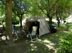
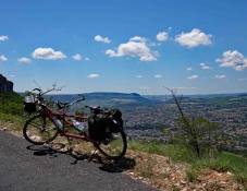
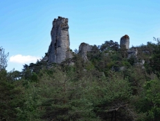
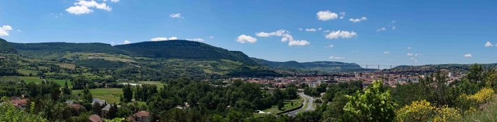
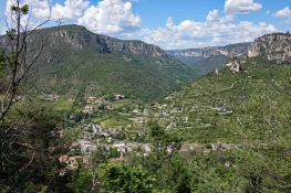
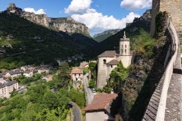
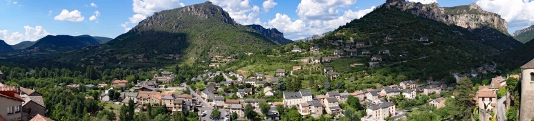
Unser letzter Campingplatz war in Le Rozier an der Jonte. Von hier aus unternahmen wir einige Radtouren und Wanderungen.
Information about copyright | |
|---|---|
Rights characteristic / license | by-sa: CREATIVE COMMONS Attribution-ShareAlike |
Link to the description of the license | |
taken over / edited on | 22 Nov 2018
|
taken over / edited by |
|
Information about copyright | |
|---|---|
Rights owner | |
Rights characteristic / license | © all rights reserved. |
Image has been uploaded | by Tandemteam-Traudel_und_Dieter on 23 Nov 2018
|
Information about copyright | |
|---|---|
Rights characteristic / license | by-sa: CREATIVE COMMONS Attribution-ShareAlike |
Link to the description of the license | |
taken over / edited on | 23 Nov 2018
|
taken over / edited by |
|
Information about copyright | |
|---|---|
Rights owner | |
Rights characteristic / license | © all rights reserved. |
Image has been uploaded | by Tandemteam-Traudel_und_Dieter on 22 Nov 2018
|
Information about copyright | |
|---|---|
Rights owner | |
Rights characteristic / license | © all rights reserved. |
Image has been uploaded | by Tandemteam-Traudel_und_Dieter on 22 Nov 2018
|
Information about copyright | |
|---|---|
Rights owner | |
Rights characteristic / license | © all rights reserved. |
Image has been uploaded | by Tandemteam-Traudel_und_Dieter on 22 Nov 2018
|
Information about copyright | |
|---|---|
Rights owner | |
Rights characteristic / license | © all rights reserved. |
Image has been uploaded | by Tandemteam-Traudel_und_Dieter on 23 Nov 2018
|
Information about copyright | |
|---|---|
Rights owner | |
Rights characteristic / license | © all rights reserved. |
Image has been uploaded | by Tandemteam-Traudel_und_Dieter on 27 Nov 2018
|
Information about copyright | |
|---|---|
Rights owner | |
Rights characteristic / license | © all rights reserved. |
Image has been uploaded | by Tandemteam-Traudel_und_Dieter on 23 Nov 2018
|
Information about copyright | |
|---|---|
Rights characteristic / license | by-sa: CREATIVE COMMONS Attribution-ShareAlike |
Link to the description of the license | |
taken over / edited on | 23 Nov 2018
|
taken over / edited by |
|
Information about copyright | |
|---|---|
Rights owner | |
Rights characteristic / license | © all rights reserved. |
Image has been uploaded | by Tandemteam-Traudel_und_Dieter on 23 Nov 2018
|
Information about copyright | |
|---|---|
Rights owner | |
Rights characteristic / license | © all rights reserved. |
Image has been uploaded | by Tandemteam-Traudel_und_Dieter on 23 Nov 2018
|
Information about copyright | |
|---|---|
Rights owner | |
Rights characteristic / license | © all rights reserved. |
Image has been uploaded | by Tandemteam-Traudel_und_Dieter on 23 Nov 2018
|
Information about copyright | |
|---|---|
Rights owner | |
Rights characteristic / license | © all rights reserved. |
Image has been uploaded | by Tandemteam-Traudel_und_Dieter on 23 Nov 2018
|
Information about copyright | |
|---|---|
Rights owner | |
Rights characteristic / license | © all rights reserved. |
Image has been uploaded | by Tandemteam-Traudel_und_Dieter on 23 Nov 2018
|