
Cycle Tour Radwandern in den Cevennen 2018
Travel report
Actions
![]()
Please wait - map data are loading
Added on 07 Nov 2018,
last edited by Tandemteam-Traudel_und_Dieter on 27 Nov 2018
Actions
Cycle route metrics
planned
ridden
Total distance in km
634
518
Cumulative elevation gain in m
13.252
8.111
Avg. slope uphill in %
2,09
1,57
Cumulative elevation loss in m
13.068
8.014
Total cycling hours
-
35,5
Avg. pace in km/h
-
14,6
Information about rights to the gps-track data | |
|---|---|
Rights owner | |
Rights characteristic / license | cc0: Public Domain no Rights reserved |
Link to the description of the license | |
GPX file uploaded | by Tandemteam-Traudel_und_Dieter on 07 Nov 2018
|
Track points in total
11.373
12.591
Track points per km (avg)
18
24
Start/endpoint
Start location
Saint-Jean-du-Gard, Occitania, FR (236 m NHN)
End location
Massegros Causses Gorges, Occitania, FR (420 m NHN)
Character
Information about copyright | |
|---|---|
Rights characteristic / license | by-sa: CREATIVE COMMONS Attribution-ShareAlike |
Link to the description of the license | |
taken over / edited on | 07 Nov 2018
|
taken over / edited by |
|
Landscape
Kulturlandschaft mit Hochplateaus und tief eingeschnittene Schluchten. Gehört zum UNESCO Weltkulturerbe.
Information about copyright | |
|---|---|
Rights characteristic / license | by-sa: CREATIVE COMMONS Attribution-ShareAlike |
Link to the description of the license | |
taken over / edited on | 07 Nov 2018
|
taken over / edited by |
|
Travel to and from ...
Mit Wohnmobil
Sources of information
Reiseführer: Reise Know-How-Verlag
"Auvergne Cevennen Zentralmassiv"
Remarks
Dieses Jahr waren wir in den Cevennen mit dem Tandem zum Radeln, und Wandern. Die Cevennen liegen in Südfrankreich Westlich der Rhone. Das höchste Bergmassiv ist der Mont Lozère mit dem Pic de Finiels (1699m). Etwas östlich dies Pic de Finiels liegt die Quelle des Tarn. Der Tarn hat eine tiefe Schlucht (bis 500m) durch die Cevennen gegraben. Die Cevennen mit ihren Hochebenen der Causses gehören zum UNESCO Weltkulturerbe.
Stages
Information about copyright | |
|---|---|
Rights owner | |
Rights characteristic / license | © all rights reserved. |
Image has been uploaded | by Tandemteam-Traudel_und_Dieter on 15 Nov 2018
|
52 km
Saint-Jean-du-Gard nach Anduze
Information about copyright | |
|---|---|
Rights owner | |
Rights characteristic / license | © all rights reserved. |
Image has been uploaded | by Tandemteam-Traudel_und_Dieter on 15 Nov 2018
|
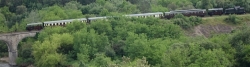
70 km
Saint-Jean-du-Gard nach Alès
Information about copyright | |
|---|---|
Rights owner | |
Rights characteristic / license | © all rights reserved. |
Image has been uploaded | by Tandemteam-Traudel_und_Dieter on 19 Nov 2018
|
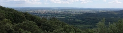
93 km
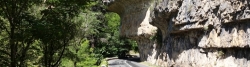
Corniche des Cévennes
Information about copyright | |
|---|---|
Rights owner | |
Rights characteristic / license | © all rights reserved. |
Image has been uploaded | by Tandemteam-Traudel_und_Dieter on 19 Nov 2018
|
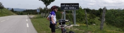
94 km
Vom Tarn über den Col de Finiels zum Lot
Information about copyright | |
|---|---|
Rights owner | |
Rights characteristic / license | © all rights reserved. |
Image has been uploaded | by Tandemteam-Traudel_und_Dieter on 22 Nov 2018
|
53 km
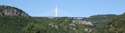
Le Rozier nach Millau
Information about copyright | |
|---|---|
Rights owner | |
Rights characteristic / license | © all rights reserved. |
Image has been uploaded | by Tandemteam-Traudel_und_Dieter on 26 Nov 2018
|
51 km
bei Millau an Tarn und Muze
Information about copyright | |
|---|---|
Rights owner | |
Rights characteristic / license | © all rights reserved. |
Image has been uploaded | by Tandemteam-Traudel_und_Dieter on 26 Nov 2018
|
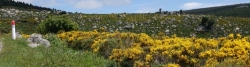
105 km
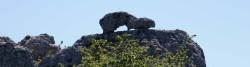
Causse de Sauveterre
Beds4Cyclists, worth visiting and infrastructure
Name and address
Latitude / Longitude
Phone
Fax
Mobile
Type of accommodation
Rating for cyclists
Route km
Dist. to route
Elevation
387 km
0,0 km
363 m
FR-12100 Paroisse Jean XXIII des Grands Causses
Tourist information
Hours of opening
Oct-Mar: Mo-Sa 09:00-12:30, 14:00-17:30, Apr-Jun, Sep: Mo-Sa 09:00-12:30, 14:00-18:30, Apr-Jun, Sep: Su 10:00-16:00, Jul, Aug: Mo-Su 09:00-19:00