
Cycle Tour Route des Crête
Rundtour: Aiguines
![]()
Please wait - map data are loading
Added on 07 Oct 2017
last edited by Tandemteam-Traudel_und_Dieter on 09 Oct 2017
Cycle route metrics
ridden
Total distance in km
85
Cumulative elevation gain in m
3.181
Avg. slope uphill in %
3,74
Cumulative elevation loss in m
3.189
Total cycling hours
6,8
Avg. pace in km/h
12,5
Min. height
479
Max. height
1.328
Information about rights to the gps-track data | |
|---|---|
Rights owner | |
Rights characteristic / license | by-sa: CREATIVE COMMONS Attribution-ShareAlike |
Link to the description of the license | |
GPX file uploaded | by Tandemteam-Traudel_und_Dieter on 07 Oct 2017
|
Track points in total
988
Track points per km (avg)
12
Start/endpoint
Start location
Aiguines, Provence-Alpes-Côte d'Azur, FR (799 m NHN)
End location
Aiguines, Provence-Alpes-Côte d'Azur, FR (791 m NHN)
ridden on
07 Jun 2017
Weather
Sonnig
Properties
Departement Straßen
Travel report
Information about copyright | |
|---|---|
Rights owner | |
Rights characteristic / license | © all rights reserved. |
Image has been uploaded | by Tandemteam-Traudel_und_Dieter on 07 Oct 2017
|
Information about copyright | |
|---|---|
Rights owner | |
Rights characteristic / license | © all rights reserved. |
Image has been uploaded | by Tandemteam-Traudel_und_Dieter on 07 Oct 2017
|
Information about copyright | |
|---|---|
Rights owner | |
Rights characteristic / license | © all rights reserved. |
Image has been uploaded | by Tandemteam-Traudel_und_Dieter on 07 Oct 2017
|
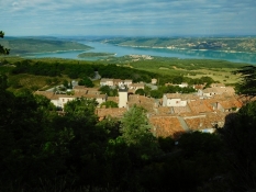
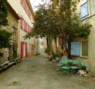
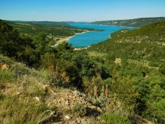
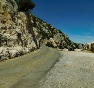
Vom Campingplatz in Aiguines radelten wir hinunter zum Lac de Sainte-Croix. Über den Verdon in Richtung Moustiers-Sainte-Marie bis zum Kreisel, und weiter auf der Route de Castellane (D 952) hinauf nach La Palud-sur-Verdon.
Information about copyright | |
|---|---|
Rights characteristic / license | by-sa: CREATIVE COMMONS Attribution-ShareAlike |
Link to the description of the license | |
taken over / edited on | 07 Oct 2017
|
taken over / edited by |
|
Information about copyright | |
|---|---|
Rights owner | |
Rights characteristic / license | © all rights reserved. |
Image has been uploaded | by Tandemteam-Traudel_und_Dieter on 07 Oct 2017
|
Information about copyright | |
|---|---|
Rights owner | |
Rights characteristic / license | © all rights reserved. |
Image has been uploaded | by Tandemteam-Traudel_und_Dieter on 07 Oct 2017
|
Information about copyright | |
|---|---|
Rights owner | |
Rights characteristic / license | © all rights reserved. |
Image has been uploaded | by Tandemteam-Traudel_und_Dieter on 07 Oct 2017
|
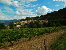
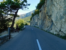
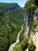
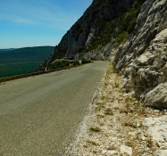
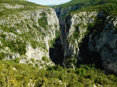
Unterwegs hat man schon schöne Ausblicke auf die Verdon-Schlucht. In Palud-sur-Verdon weiter auf der Route de Castellane! Man Sollte so herum Radeln, denn die D 23 wird zur Einbahnstraße!
Information about copyright | |
|---|---|
Rights characteristic / license | by-sa: CREATIVE COMMONS Attribution-ShareAlike |
Link to the description of the license | |
taken over / edited on | 07 Oct 2017
|
taken over / edited by |
|
Information about copyright | |
|---|---|
Rights owner | |
Rights characteristic / license | © all rights reserved. |
Image has been uploaded | by Tandemteam-Traudel_und_Dieter on 07 Oct 2017
|
Information about copyright | |
|---|---|
Rights owner | |
Rights characteristic / license | © all rights reserved. |
Image has been uploaded | by Tandemteam-Traudel_und_Dieter on 07 Oct 2017
|
Information about copyright | |
|---|---|
Rights owner | |
Rights characteristic / license | © all rights reserved. |
Image has been uploaded | by Tandemteam-Traudel_und_Dieter on 07 Oct 2017
|
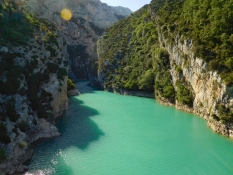
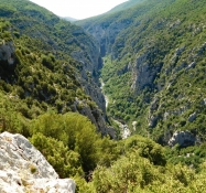
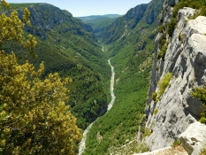
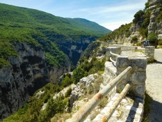
Nach Palud-sur-Verdon zweigt die D 23 (Route des Crête) rechts ab, und es geht hinauf zur Verdon-Schlucht. Den ersten Belvédère erreicht man nach ca. 5 Km von Palud-sur-Verdon hoch über dem Verdon mit tollem Blick in die Schlucht.
Information about copyright | |
|---|---|
Rights characteristic / license | by-sa: CREATIVE COMMONS Attribution-ShareAlike |
Link to the description of the license | |
taken over / edited on | 07 Oct 2017
|
taken over / edited by |
|
Information about copyright | |
|---|---|
Rights owner | |
Rights characteristic / license | © all rights reserved. |
Image has been uploaded | by Tandemteam-Traudel_und_Dieter on 07 Oct 2017
|
Information about copyright | |
|---|---|
Rights owner | |
Rights characteristic / license | © all rights reserved. |
Image has been uploaded | by Tandemteam-Traudel_und_Dieter on 07 Oct 2017
|
Information about copyright | |
|---|---|
Rights owner | |
Rights characteristic / license | © all rights reserved. |
Image has been uploaded | by Tandemteam-Traudel_und_Dieter on 07 Oct 2017
|
Information about copyright | |
|---|---|
Rights owner | |
Rights characteristic / license | © all rights reserved. |
Image has been uploaded | by Tandemteam-Traudel_und_Dieter on 07 Oct 2017
|
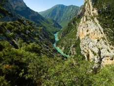
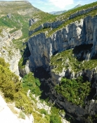
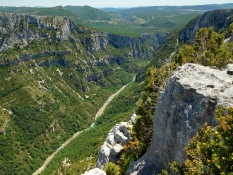
Zwischen dem 6. und 7. Belvédère erreicht man den höchsten Punkt der Radtour. Rasant geht es hinunter mit noch einigen Aussichtspunkten bis zum Punkt 12 Chalet de la Maline. Hier besteht die Möglichkeit die Verdon-Schlucht (Sentier Blanc-Martel) zu durchwandern.
Information about copyright | |
|---|---|
Rights characteristic / license | by-sa: CREATIVE COMMONS Attribution-ShareAlike |
Link to the description of the license | |
taken over / edited on | 07 Oct 2017
|
taken over / edited by |
|
Information about copyright | |
|---|---|
Rights owner | |
Rights characteristic / license | © all rights reserved. |
Image has been uploaded | by Tandemteam-Traudel_und_Dieter on 07 Oct 2017
|
Information about copyright | |
|---|---|
Rights owner | |
Rights characteristic / license | © all rights reserved. |
Image has been uploaded | by Tandemteam-Traudel_und_Dieter on 07 Oct 2017
|
Information about copyright | |
|---|---|
Rights owner | |
Rights characteristic / license | © all rights reserved. |
Image has been uploaded | by Tandemteam-Traudel_und_Dieter on 07 Oct 2017
|
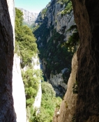
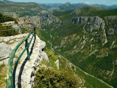
Nach einer Kaffeepause beim Chalet de la Maline, geht es noch weiter abwärts bis zum Belvédère de Maugué (13). Beim Belvédère de l'Imbut (14) verlassen wir die Verdon-Schlucht und radeln wieder hoch nach La Palud-sur-Verdon.
Information about copyright | |
|---|---|
Rights characteristic / license | by-sa: CREATIVE COMMONS Attribution-ShareAlike |
Link to the description of the license | |
taken over / edited on | 07 Oct 2017
|
taken over / edited by |
|
Information about copyright | |
|---|---|
Rights owner | |
Rights characteristic / license | © all rights reserved. |
Image has been uploaded | by Tandemteam-Traudel_und_Dieter on 07 Oct 2017
|
Information about copyright | |
|---|---|
Rights owner | |
Rights characteristic / license | © all rights reserved. |
Image has been uploaded | by Tandemteam-Traudel_und_Dieter on 07 Oct 2017
|
Information about copyright | |
|---|---|
Rights owner | |
Rights characteristic / license | © all rights reserved. |
Image has been uploaded | by Tandemteam-Traudel_und_Dieter on 07 Oct 2017
|
Information about copyright | |
|---|---|
Rights characteristic / license | by-sa: CREATIVE COMMONS Attribution-ShareAlike |
Link to the description of the license | |
taken over / edited on | 07 Oct 2017
|
taken over / edited by |
|
Information about copyright | |
|---|---|
Rights owner | |
Rights characteristic / license | © all rights reserved. |
Image has been uploaded | by Tandemteam-Traudel_und_Dieter on 07 Oct 2017
|

Information about copyright | |
|---|---|
Rights owner | |
Rights characteristic / license | © all rights reserved. |
Image has been uploaded | by Tandemteam-Traudel_und_Dieter on 07 Oct 2017
|
Information about copyright | |
|---|---|
Rights owner | |
Rights characteristic / license | © all rights reserved. |
Image has been uploaded | by Tandemteam-Traudel_und_Dieter on 07 Oct 2017
|