
Radtour Bamberg - Bernburg - Münster
Geplante Tour
Aktionen
![]()
Bitte warten - Kartendaten werden geladen
Erstellt am 03.03.2013,
zuletzt geändert von »TheLonesomeBiker« am 03.03.2013
Aktionen
Strecken-Merkmale
geplant
gefahren
Gesamtlänge in km
982
0
Gesamthöhenmeter Aufstieg
11.142
0
Durchschn. Steigung Aufstieg %
1,13
-
Gesamthöhenmeter Abstieg
11.323
0
Informationen zu Rechten an den GPS-Track-Daten | |
|---|---|
Rechte-Inhaber | HeinzM & biroto-Contributors |
Rechte-Ausprägung / Lizenz | by-sa: CREATIVE COMMONS Namensnennung, Weitergabe unter gleichen Bedingungen |
Link zur Rechtebeschreibung | |
gpx-Datei übernommen aus | |
gpx-Datei hochgeladen | durch »TheLonesomeBiker« am 03.03.2013
|
Gesamtzahl Trackpoints
9.635
0
Trackpoint-Dichte per km
10
0
Endorte
Start
Bamberg, Bayern, DE (243 m NHN)
Ziel
Münster, Nordrhein-Westfalen, DE (62 m NHN)
Fahrradfreundliche Unterkünfte, Sehenswertes und Infrastruktur
Name u. Anschrift
Breite / Länge
Tel.
Fax.
Mobile
Art d. Unterkunft
Radler-freund-lichkeit
Strecken-km
km zur Strecke
Höhe
0 km
0,6 km
253 m
0 km
0,1 km
237 m
0 km
0,8 km
225 m
Öffnungszeiten
Montag bis Freitag: 9.30-18 Uhr
Samstag: 9.30-15 Uhr
Sonn- und Feiertage: 9.30-14.00 Uhr
0 km
2,5 km
368 m
Informationen zu Urheber-Rechten | |
|---|---|
Rechte-Inhaber | Otto Först |
Rechte-Ausprägung / Lizenz | cc0: Public Domain keine Rechte vorbehalten |
Link zur Rechtebeschreibung | |
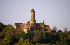
Bild übernommen aus | commons.wikimedia.org/wiki/File:Altenburg_von_Süden_14-09-2003_(3).JPG |
Bild hochgeladen | durch ThimbleU am 05.08.2013
|
Informationen zu Urheber-Rechten | |
|---|---|
Rechte-Inhaber | |
Rechte-Ausprägung / Lizenz | cc0: Public Domain keine Rechte vorbehalten |
Link zur Rechtebeschreibung | |
Bild übernommen aus | |
Bild hochgeladen | durch ThimbleU am 05.08.2013
|

Informationen zu Urheber-Rechten | |
|---|---|
Rechte-Inhaber | |
Rechte-Ausprägung / Lizenz | by-sa: CREATIVE COMMONS Namensnennung, Weitergabe unter gleichen Bedingungen |
Link zur Rechtebeschreibung | |
Bild übernommen aus | commons.wikimedia.org/wiki/File:Bamberg_BW_2011-06-29_08-44-28.jpg |
Bild hochgeladen | durch ThimbleU am 05.08.2013
|
Informationen zu Urheber-Rechten | |
|---|---|
Rechte-Inhaber | |
Rechte-Ausprägung / Lizenz | by-sa: CREATIVE COMMONS Namensnennung, Weitergabe unter gleichen Bedingungen |
Link zur Rechtebeschreibung | |
Bild übernommen aus | commons.wikimedia.org/wiki/File:Bamberg_BW_2011-06-29_08-44-46.JPG |
Bild hochgeladen | durch ThimbleU am 05.08.2013
|
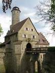
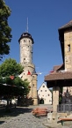
Die Altenburg ist eine mittelalterliche Höhenburg in der kreisfreien Stadt Bamberg im bayerischenRegierungsbezirk Oberfranken.
Die Altenburg wurde 1109 erstmals in einer Urkunde erwähnt, mit der Bischof Otto von Bamberg die Burganlage dem Kollegiatstift St. Jakob übereignete. Die Burg war von 1305 bis 1553 die zweite Residenz der Bamberger Fürstbischöfe. In ihren heutigen Ausmaßen entstand die Burg im frühen 15. Jahrhundert.
Im Bauernkrieg 1524/1525 wurde die Altenburg zwar belagert, aber weder eingenommen noch sind schwerwiegende Zerstörungen überliefert.
Im Zweiten Markgrafenkrieg von 1553 wurde die Burg nicht durch Erstürmung, sondern nach der Übergabe an das Kriegsheer des Markgrafen Albrecht Alcibiades von Brandenburg-Kulmbach der Zerstörung preisgegeben.
Ein Erdrutsch zerstörte im letzten Viertel des 18. Jahrhunderts Teile der Ostmauer. Diese Mauern wurden erst wieder im beginnenden 21. Jahrhundert in Sichtbeton neu errichtet.
Informationen zu Urheber-Rechten | |
|---|---|
Rechte-Ausprägung / Lizenz | by-sa: CREATIVE COMMONS Namensnennung, Weitergabe unter gleichen Bedingungen |
Link zur Rechtebeschreibung | |
Text(e) übernommen von: |
Seite „Altenburg (Bamberg)“. In: Wikipedia, Die freie Enzyklopädie. Bearbeitungsstand: 7. April 2013, 11:59 UTC. URL: http://de.wikipedia.org/w/index.php?title=Altenburg_(Bamberg)&oldid=117222907 (Abgerufen: 5. August 2013, 11:24 UTC) |
übernommen / bearbeitet am | 05.08.2013
|
übernommen / bearbeitet durch |
|
0 km
0,9 km
232 m
![]()