
Cycle Tour Bike week in Franconia and Bavaria
Dag 5, etape/stage 4: Riedenburg-Regensburg
![]()
Please wait - map data are loading
Added on 07 Jul 2014
last edited by Ottocolor on 07 Sep 2014
Cycle route metrics
ridden
Total distance in km
54
Cumulative elevation gain in m
194
Avg. slope uphill in %
0,36
Cumulative elevation loss in m
215
Min. height
346
Max. height
397
Information about rights to the gps-track data | |
|---|---|
Rights owner | |
Rights characteristic / license | by-sa: CREATIVE COMMONS Attribution-ShareAlike |
Link to the description of the license | |
GPX file uploaded | by Ottocolor on 07 Jul 2014
|
Track points in total
938
Track points per km (avg)
17
Start/endpoint
Start location
Riedenburg, Bayern, DE (368 m NHN)
End location
Niederwinzer, Bayern, DE (347 m NHN)
ridden on
20 Jun 2014
Weather
Cloudy weater with a short brightning in the afternoon. Somewhat cooler. The wind moderate to fresh from West, so it was tailwind first, later side-, head- and tailwind. Due to the Danube's curved run.
Accommodation
AZUR Camping Regensburg
Weinweg 40
DE-93049 Regensburg
Properties
Gravel paths along the river Altmuehl. Along the Danube the bike route had more various character with both tarmac and gravel paths, minor roads in villages and one rather short stretch on a noisy road. After the town of Bad Abbach again by the riverside, mostly on gravel paths.
Slope Gradient Distribution
Remarks
The bike week's fourth stage and fifth day. The last biking stage to the end goal in the city of Regensburg.
Travel report
Information about copyright | |
|---|---|
Rights owner | |
Rights characteristic / license | by-sa: CREATIVE COMMONS Attribution-ShareAlike |
Link to the description of the license | |
Image has been uploaded | by Ottocolor on 11 Jul 2014
|
Information about copyright | |
|---|---|
Rights owner | |
Rights characteristic / license | by-sa: CREATIVE COMMONS Attribution-ShareAlike |
Link to the description of the license | |
Image has been uploaded | by Ottocolor on 11 Jul 2014
|
Information about copyright | |
|---|---|
Rights owner | |
Rights characteristic / license | by-sa: CREATIVE COMMONS Attribution-ShareAlike |
Link to the description of the license | |
Image has been uploaded | by Ottocolor on 11 Jul 2014
|
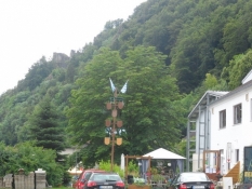
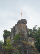
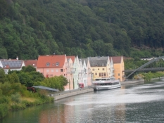
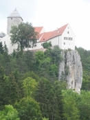
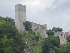
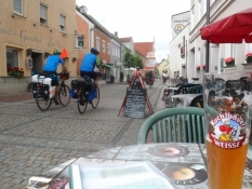
When I woke up in the tent, it still hurt a little in the eyes after I had slept with lenses most of the night. I decided to wear glasses today to protect my eyes and spare them for the lenses. That's a lesson for me. I had not shopped for breakfast yesterday, and it turned out a long trip, as I had to go to the opposite end of Riedenburg on the opposite bank, where all the supermarkets were gathered. That was a lesson too! So it was a little late before I came away. And then I was also 'stopped' by the delightful little town that I only had seen in the dark yesterday. Unfortunately, the sun wasn't out. Actually, it was quite cool. But the wind blew in the right direction. I stood long looking from a bridge over the river, where I had a fine view of the town and the river valley. There were several castles perched on the hillsides. One place it was a picturesque ruin with a German flag in front. It might have been cool to have a rest day here, relax, enjoy the town and slog up to the castle ruins. But the goal today was Regensburg. A city, I looked forward to see tomorrow, and this WAS indeed a bikeweek. So into the pedals and go along in the lovely Altmuehl valley. Here the trail was quite narrow and bumpy, but it was awfully cozy too. Before long, I had found a table and benches set straight down to the river, where I ate my buttered sandwiches. Also here there was a view of a castle perched on the cliff ridge. The castle was Prunn. It looked quite dramatic on its rocky outcrop up there.
Information about copyright | |
|---|---|
Rights characteristic / license | by-sa: CREATIVE COMMONS Attribution-ShareAlike |
Link to the description of the license | |
taken over / edited on | 06 Sep 2014
|
taken over / edited by |
|
Information about copyright | |
|---|---|
Rights owner | |
Rights characteristic / license | by-sa: CREATIVE COMMONS Attribution-ShareAlike |
Link to the description of the license | |
Image has been uploaded | by Ottocolor on 11 Jul 2014
|
Information about copyright | |
|---|---|
Rights owner | |
Rights characteristic / license | by-sa: CREATIVE COMMONS Attribution-ShareAlike |
Link to the description of the license | |
Image has been uploaded | by Ottocolor on 11 Jul 2014
|
Information about copyright | |
|---|---|
Rights owner | |
Rights characteristic / license | by-sa: CREATIVE COMMONS Attribution-ShareAlike |
Link to the description of the license | |
Image has been uploaded | by Ottocolor on 11 Jul 2014
|
Information about copyright | |
|---|---|
Rights owner | |
Rights characteristic / license | by-sa: CREATIVE COMMONS Attribution-ShareAlike |
Link to the description of the license | |
Image has been uploaded | by Ottocolor on 11 Jul 2014
|
Information about copyright | |
|---|---|
Rights owner | |
Rights characteristic / license | by-sa: CREATIVE COMMONS Attribution-ShareAlike |
Link to the description of the license | |
Image has been uploaded | by Ottocolor on 11 Jul 2014
|
Information about copyright | |
|---|---|
Rights owner | |
Rights characteristic / license | by-sa: CREATIVE COMMONS Attribution-ShareAlike |
Link to the description of the license | |
Image has been uploaded | by Ottocolor on 11 Jul 2014
|
Information about copyright | |
|---|---|
Rights owner | |
Rights characteristic / license | by-sa: CREATIVE COMMONS Attribution-ShareAlike |
Link to the description of the license | |
Image has been uploaded | by Ottocolor on 11 Jul 2014
|
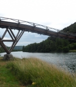
The next thing I noticed was a nice curved wooden bridge over the river. And the curves went up and down! I had never seen such a contraption before, so I had to look at it now. Although it was hard to cross the highway that ran along the path and which the bridge also crossed. The frigging cars drove insanely fast. They could have put up a traffic light for pedestrians here, as the wooden bridge probebly attracted more cyclists on the route through the Altmuehl valley. But it turned out to be a project that was built especially to accommodate pedestrians and the nature in the valley, which supposedly was dramatically threatened by the Main-Danube canal's placement here. So that made a lot of money flow out of the funds for the construction of a unique wooden bridge for pedestrians and cyclists, I read on a poster. The idea of letting it go up and down in long arcs had a static reason. In that form it could sustain itself, and the two pillars on both sides, again according to the poster text, carry only a small part of the bridge's weight. Being a mathematical idiot I grapped nothing of that, but I was nonetheless impressed and walked out to the middle of the bridge. It was called Tatzelwurm, named after a mythical creature that looks like a fat lizard, probably because of the curved course and was until 2006 Europe's longest wooden bridge before the title went to another bridge in Germany. They obviously had placed it a beautiful place in the valley with a view of yet another castle, Burg Essing up on top. Peace was only disturbed by the enervating highway. I do not understand how the canal was supposed to destroy the landscape and especially the experience of it in the same degree as the highway. But a road has of course always the right to go where it goes. But now the village of Essing at least is connected in a beautiful way to the opposite river bank, where peace and quiet still reigned and where you could enjoy the unspoiled nature.
Information about copyright | |
|---|---|
Rights characteristic / license | by-sa: CREATIVE COMMONS Attribution-ShareAlike |
Link to the description of the license | |
taken over / edited on | 06 Sep 2014
|
taken over / edited by |
|
Information about copyright | |
|---|---|
Rights owner | |
Rights characteristic / license | by-sa: CREATIVE COMMONS Attribution-ShareAlike |
Link to the description of the license | |
Image has been uploaded | by Ottocolor on 11 Jul 2014
|
Information about copyright | |
|---|---|
Rights owner | |
Rights characteristic / license | by-sa: CREATIVE COMMONS Attribution-ShareAlike |
Link to the description of the license | |
Image has been uploaded | by Ottocolor on 11 Jul 2014
|
Information about copyright | |
|---|---|
Rights owner | |
Rights characteristic / license | by-sa: CREATIVE COMMONS Attribution-ShareAlike |
Link to the description of the license | |
Image has been uploaded | by Ottocolor on 11 Jul 2014
|
Information about copyright | |
|---|---|
Rights owner | |
Rights characteristic / license | by-sa: CREATIVE COMMONS Attribution-ShareAlike |
Link to the description of the license | |
Image has been uploaded | by Ottocolor on 11 Jul 2014
|
Information about copyright | |
|---|---|
Rights owner | |
Rights characteristic / license | by-sa: CREATIVE COMMONS Attribution-ShareAlike |
Link to the description of the license | |
Image has been uploaded | by Ottocolor on 11 Jul 2014
|
Information about copyright | |
|---|---|
Rights owner | |
Rights characteristic / license | by-sa: CREATIVE COMMONS Attribution-ShareAlike |
Link to the description of the license | |
Image has been uploaded | by Ottocolor on 11 Jul 2014
|
Information about copyright | |
|---|---|
Rights owner | |
Rights characteristic / license | by-sa: CREATIVE COMMONS Attribution-ShareAlike |
Link to the description of the license | |
Image has been uploaded | by Ottocolor on 11 Jul 2014
|
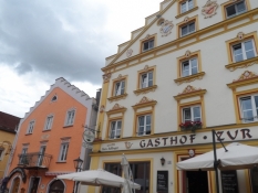
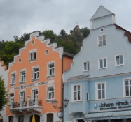
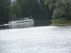
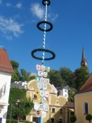
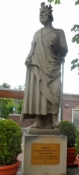
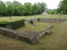
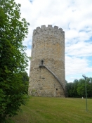
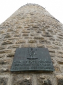
After the wooden bridge it was not far to Kelheim, which I had an idea to look at, but could not decide where to leave the path. I had thought there would be an obvious choice, but the town lay on the other side of the canal / river which was very wide here, and then I had cycled past the town. On one hand it was a pity, as it is said to be a beautiful town at Altmühl's mouth into the Danube with a charming old town. On the other hand, I could easily have spent far too much time in there, because there was also a brewery with a magnificent brewpub. It was the renowned brewery Schneider Weisse's entailed estate, a brewery, which has a large house in Munich, where they serve really many excellent types of wheat beer and where my friend Kolja and I several times have 'gone down'. Plus it was still early in the day. When all that added up, it was very well, I had skipped that town! There was also the 'danger' that I had taken a riverboat up the Danube to the so-called Danube breakthrough, a natural scenery, where the mighty stream breaks through a rock formation. There is also a famous monastery Weltenburg where god-help-me there is also a brewery. So Kelheim was obviosly a dangerous town to avoid. I'll be back some other day. Instead I lay a little in the grass right where the canal and the Altmühl flows into the Danube. It was a totally harmless and dull piece of grass, even with thistles in it, so I did not stay long there. But long enough to see a tour boat come chugging down the canal, probably from Kelheim town centre, and swing out on the Danube by a big curve and put every effort into sailing up the river, probably to Weltenburg and the Danube breakthrough. Have a nice trip! Also myself, who suddenly found himself on one of Europe's most famous cycling route, the Danube Cycle Route, (yes, one is tempted to spell it with capital letters). The most obvious difference was the much bigger number of cyclists going either direction. Plus the signposting was much better. But the route course itself was a little disappointing after the Altmühl route, which had its own path, partly on asphalt. Here the course constantly changed between separate bike paths, small roads in villages and before the town of Kapfelberg even a single mile on a busy road. But then the route crossed to the other side of the Danube and here began a nice paved bike path, as I had imagined the Danube bike route to be. As I had been 'cheated' of Kelheim, I wanted to have a look at Bad Abbach instead. I had imagined a beautiful, old town right down to the banks of the Danube, but it was a little disappointing that, again, if you wish, a busy expressway divided the town from the river. Along the main street, I found a large bakery, where a lot of cyclists were sitting outside drinking coffee and eating cake. Within the shop many clerks were lashing goods across the counter to the waiting cyclists. The Danube Bike Trail must be big business for these kinds of places. Noisy machines from a construction site nearby disturbed the coziness. Then I wanted to find the town centre, but was already on the way out of town before I had found it. Curiously, that's not like a German town. Eventually I found a very small square with a maypole in front of a stately building. It had to be the town hall then. Okay, here it was. I sat down and had a weissbier contemplating what to do. From my seat I could see up to a ruined castle perched above the town, but not that far up. And suddenly wanted to go up there. I was told at the cafe, there were stairs there, but the castle tower, which was open to the public, was closed today. Okay, I went up the stairs and through a forest. Upon arrival at the castle, the view was not very good, there were trees in the way. And the town was completely hidden beneath me. The castle itself was only a ruin, while the tower looked heavily restored. I walked around it and read on a bronze plate that the Holy Roman emperor Heinrich II was born in 973 or 978, and the tower was therefore called Heinrichsturm (Henry's Tower). Down in the town there was a stone statue of him, and it said that he was born either here or in Hildesheim in northern Germany, where I have been many times. So they must have been important towns of that time. Later, they lost importance, Bad Abbach certainly due to the near Regensburg's rising shortly after. And there I was going now.
Information about copyright | |
|---|---|
Rights characteristic / license | by-sa: CREATIVE COMMONS Attribution-ShareAlike |
Link to the description of the license | |
taken over / edited on | 07 Sep 2014
|
taken over / edited by |
|
Information about copyright | |
|---|---|
Rights owner | |
Rights characteristic / license | by-sa: CREATIVE COMMONS Attribution-ShareAlike |
Link to the description of the license | |
Image has been uploaded | by Ottocolor on 11 Jul 2014
|
Information about copyright | |
|---|---|
Rights owner | |
Rights characteristic / license | by-sa: CREATIVE COMMONS Attribution-ShareAlike |
Link to the description of the license | |
Image has been uploaded | by Ottocolor on 11 Jul 2014
|
Information about copyright | |
|---|---|
Rights owner | |
Rights characteristic / license | by-sa: CREATIVE COMMONS Attribution-ShareAlike |
Link to the description of the license | |
Image has been uploaded | by Ottocolor on 11 Jul 2014
|
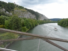
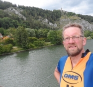
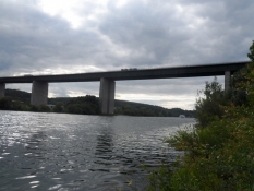
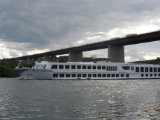
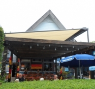
After Bad Abbach I drove out of the paper map, I like to have on top of my handlebar bag, although the navigation unit also has a map. However, it covers only a very small area around the spot where you are. And I let my direction follow the map, so I have no feel for the direction in which I run. And then suddenly there was a headwind, I thought that the wind had turned. I had had tailwind so far. But I followed the Danube River, and it made some big bends to the north and west, so I actually rode some distance back. And the path that was paved and followed the river, was very well signposted. When I got to a high motorway bridge over the river, I made a breakt right by the river and looked at the many boats that sailed past. I had not expected the Danube to be so wide here, only a few hundred kilometers from its source in the Black Forest. I wondered how wide it was, for example, in Belgrade, hundreds of miles down the course? The river receives the waters of many major tributaries before it flows into the Black Sea more than two thousand miles from here. This makes it Europe's second longest river, surpassed only by the Volga in Russia. But where this river flows through just one country the Danube runs through a whopping ten. Therefore, it also has many names according to their languages. I was not very fresh, and it was as if the headwinds cost undue effort. It wasn't that strong after all. And soon the river swung to the east again, which is its main direction. Shortly before Regensburg it reached the northernmost point of its entire course. Gradually Regensburg's leisure areas, sports fields and swimming pools began to appear. Now it was a gravel path on a dike that protected the low areas south of the river. And then I was suddenly near the campsite. Here I had been with my son Simon the year before, where we had stayed one night here before the ride home in the car. And now I would stay here again and have a look at the city the following day. For now 'I moved in' and sat down in the large covered restaurant area to watch a game from the World Cup. The biggest surprise here so far Costa Rica won against Italy, sending them home along with England. Total South and Central American triumph in that group. Afterwards I was ready to lie down in the tent for my bike week's last tent accommodation.
Information about copyright | |
|---|---|
Rights characteristic / license | by-sa: CREATIVE COMMONS Attribution-ShareAlike |
Link to the description of the license | |
taken over / edited on | 07 Sep 2014
|
taken over / edited by |
|