
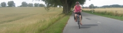
Cycle Tour Müritz - Berlin - Müritz
Travel report
Actions
![]()
Please wait - map data are loading
Added on 17 Nov 2011,
last edited by ThimbleU on 19 Nov 2011
Actions
Cycle route metrics
planned
ridden
Total distance in km
390
405
Cumulative elevation gain in m
1.754
2.383
Avg. slope uphill in %
0,45
0,59
Cumulative elevation loss in m
1.754
2.384
Total cycling hours
-
23,8
Avg. pace in km/h
-
17,0
Information about rights to the gps-track data | |
|---|---|
Rights owner | |
Rights characteristic / license | by-nc-sa: CREATIVE COMMONS Attribution-NonCommercial-ShareAlike |
Link to the description of the license | |
GPX file uploaded | by ThimbleU on 17 Nov 2011
|
Track points in total
1.013
6.399
Track points per km (avg)
3
16
Start/endpoint
Start location
Waren (Müritz), Mecklenburg-Vorpommern, DE (76 m NHN)
End location
Waren (Müritz), Mecklenburg-Vorpommern, DE (76 m NHN)
Stages
95 km
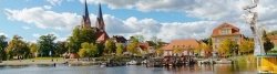
Kölpinsee - Fürstenberg
117 km
Fürstenberg - Schönwalde
Information about copyright | |
|---|---|
Rights owner | |
Rights characteristic / license | by-sa: CREATIVE COMMONS Attribution-ShareAlike |
Link to the description of the license | |
Image taken over from | https://commons.wikimedia.org/wiki/File:Neuruppin_St._Trinitatis-01.jpg |
Image has been uploaded | by ThimbleU on 19 Dec 2021
|
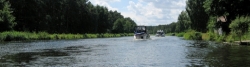
91 km
Schönwalde - Boltenmühle
Information about copyright | |
|---|---|
Rights owner | |
Rights characteristic / license | by-sa: CREATIVE COMMONS Attribution-ShareAlike |
Link to the description of the license | |
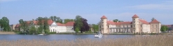
Image taken over from | https://commons.wikimedia.org/wiki/File:Schloss_Rheinsberg.jpg |
Image has been uploaded | by ThimbleU on 19 Dec 2021
|
102 km
Boltenmühle - Kölpinsee
Beds4Cyclists, worth visiting and infrastructure
Name and address
Latitude / Longitude
Phone
Fax
Mobile
Type of accommodation
Rating for cyclists
Route km
Dist. to route
Elevation
2 km
0,3 km
74 m
5 km
3,0 km
56 m
6 km
0,3 km
56 m
6 km
0,7 km
65 m
6 km
0,1 km
58 m
![]()