
Radtour Nagold- und Enztalradweg
Geplante Tour
Aktionen
![]()
Bitte warten - Kartendaten werden geladen
Erstellt am 19.04.2017,
zuletzt geändert von biroto-Redaktion am 20.04.2017
Aktionen
Strecken-Merkmale
geplant
gefahren
Gesamtlänge in km
224
0
Gesamthöhenmeter Aufstieg
3.889
0
Durchschn. Steigung Aufstieg %
1,74
-
Gesamthöhenmeter Abstieg
3.986
0
Informationen zu Rechten an den GPS-Track-Daten | |
|---|---|
Rechte-Inhaber | |
Rechte-Ausprägung / Lizenz | cc0: Public Domain keine Rechte vorbehalten |
Link zur Rechtebeschreibung | |
gpx-Datei hochgeladen | durch biroto-Redaktion am 20.04.2017
|
Gesamtzahl Trackpoints
4.214
0
Trackpoint-Dichte per km
19
0
Endorte
Start
Pforzheim, Baden-Württemberg, DE (282 m NHN)
Ziel
Walheim, Baden-Württemberg, DE (185 m NHN)
Fahrradfreundliche Unterkünfte, Sehenswertes und Infrastruktur
Name u. Anschrift
Breite / Länge
Tel.
Fax.
Mobile
Art d. Unterkunft
Radler-freund-lichkeit
Strecken-km
km zur Strecke
Höhe
0 km
0,1 km
297 m
15 km
2,1 km
449 m
21 km
0,1 km
327 m
21 km
0,5 km
435 m
25 km
0,3 km
348 m
Informationen zu Urheber-Rechten | |
|---|---|
Rechte-Inhaber | |
Rechte-Ausprägung / Lizenz | by-sa: CREATIVE COMMONS Namensnennung, Weitergabe unter gleichen Bedingungen |
Link zur Rechtebeschreibung | |
Bild übernommen aus | https://commons.wikimedia.org/wiki/File:Kloster_Hirsau_2010.jpg |
Bild hochgeladen | durch biroto-Redaktion am 17.01.2021
|
Informationen zu Urheber-Rechten | |
|---|---|
Rechte-Inhaber | |
Rechte-Ausprägung / Lizenz | by-sa: CREATIVE COMMONS Namensnennung, Weitergabe unter gleichen Bedingungen |
Link zur Rechtebeschreibung | |
Bild übernommen aus | https://commons.wikimedia.org/wiki/File:Hirsau-20-Marienkapelle-1990-gje.jpg |
Bild hochgeladen | durch biroto-Redaktion am 17.01.2021
|
Informationen zu Urheber-Rechten | |
|---|---|
Rechte-Inhaber | https://web.archive.org/web/20161012134629/www.panoramio.com/user/596286?with_photo_id=985883 |
Rechte-Ausprägung / Lizenz | by: CREATIVE COMMONS Namensnennung |
Link zur Rechtebeschreibung | |
Bild übernommen aus | |
Bild hochgeladen | durch biroto-Redaktion am 17.01.2021
|
Informationen zu Urheber-Rechten | |
|---|---|
Rechte-Inhaber | |
Rechte-Ausprägung / Lizenz | by-sa: CREATIVE COMMONS Namensnennung, Weitergabe unter gleichen Bedingungen |
Link zur Rechtebeschreibung | |
Bild übernommen aus | https://commons.wikimedia.org/wiki/File:KlosterHirsau-Kreuzgang-02.jpg |
Bild hochgeladen | durch biroto-Redaktion am 17.01.2021
|
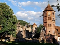
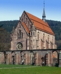
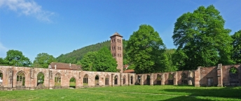
Das Kloster Hirsau war eine bedeutende Benediktinerabtei in Hirsau ![]() im Nordschwarzwald. Meist meint man damit die Anlage St. Peter und Paul. Im weiteren Sinn umfasst die Bezeichnung jedoch auch deren Vorläufer St. Aurelius.
im Nordschwarzwald. Meist meint man damit die Anlage St. Peter und Paul. Im weiteren Sinn umfasst die Bezeichnung jedoch auch deren Vorläufer St. Aurelius.
Hirsau (vormals auch Hirschau) war zeitweise eines der bedeutendsten Klöster Deutschlands. Es diente der cluniazensischen Reformbewegung sehr früh als deutscher Stützpunkt. Von hier ging eine Reihe von Klostergründungen aus, aber auch die Erneuerung bestehender Gemeinschaften nach der sogenannten Hirsauer Reform. Zum Zeitpunkt seiner Errichtung im späten 11. Jahrhundert war St. Peter und Paul das baulich größte Kloster im deutschsprachigen Raum. Während des Pfälzischen Erbfolgekriegs brannte die Anlage 1692 aus und verfiel dann.
St. Peter und Paul
Dank der als vorbildhaft empfundenen Lebensweise seiner Mönche und der Reformen des Abtes Wilhelm (ab 1069) hatte Hirsau großen Zulauf. St. Aurelius wurde daher innerhalb kurzer Zeit liturgisch und räumlich ungenügend. Häufiges Hochwasser der Nagold und möglicherweise auch der Wunsch nach Verdeutlichung des Machtanspruchs der Kirche im Investiturstreit ließen den Bau einer größeren, günstiger gelegenen Anlage geboten erscheinen.
Im Jahre 1082 begannen die Bauarbeiten mit der Einebnung eines Plateaus auf der Aurelius gegenüber liegenden Nagoldseite. Die Weihe der Kirche erfolgte bereits 1091. Ab 1092 siedelte der Konvent vom Aurelius- ins Peter-und-Pauls-Kloster über. Die Fertigstellung aller Klausurgebäude zog sich jedoch noch bis zur Mitte des 12. Jahrhunderts hin. Abt Wilhelm benutzte als architektonische Vorlage Cluny II, den sogenannten Maiolus-Bau. Dies geschah analog zur Übernahme der cluniazensischen Klosterregeln. Die Kirche war eine romanische, flachgedeckte, dreischiffige Säulenbasilika mit Querhaus und rechteckigem, mehrschiffigem Chor. Ihre Länge betrug zunächst 70 Meter. Ihr Langhaus umfasste neun Joche. Die beiden Westtürme, von denen nur noch der nördliche steht, waren ursprünglich nicht vorgesehen. Sie wurden im Jahre 1120 fertiggestellt und standen ursprünglich vor einem Atrium. Dieses erhielt in einer letzten Bauphase seine basilikale Überdachung. Das Langhaus verlängerte sich damit um 30 Meter auf 13 Joche. Südlich der Kirche schlossen sich um einen Kreuzgang herum Kapitelsaal, Kapelle, Speisesaal, Abthaus und andere Klausurgebäude an.
Mitte des 15. Jahrhunderts erlebte Hirsau eine zweite wirtschaftliche und geistige Blüte. Es unterhielt Kontakte zur Melker Klosterreform und schloss sich 1458 der Bursfelder Kongregation an, einer monastischen Reformbewegung.
Im Jahre 1474 begann unter Erhaltung der Abteikirche der Abriss der romanischen Klausurgebäude, die man bis 1516 durch gotische Neubauten ersetzte.
Im Jahre 1536 wurde im Zuge der Reformation der Benediktiner-Konvent aufgelöst, 1556 das Kloster St. Peter und Paul in eine evangelische Klosterschule umgewandelt. Im Dreißigjährigen Krieg kehrten noch einmal benediktinische Mönche aus Weingarten zurück. 1630–1651 wechselte der Besitz Hirsaus mehrfach zwischen katholischen und evangelischen Herren.
Von 1586 bis 1592 ließen Württembergs Herzöge, südlich im Anschluss an die Klausur, anstelle des Abthauses ein dreiflügeliges Schloss im Renaissancestil erbauen.
Während einer Belagerung durch französische Truppen unter General Mélac im Pfälzischen Erbfolgekrieg gingen Schloss und Kloster 1692 in Flammen auf. Fehlten zunächst meist nur die Dächer, verlor die Anlage bis 1808 zunehmend auch Mauerwerk, das man u. a. für den Wiederaufbau von Calw verwendete. Erhalten blieben vollständig nur die spätgotische Marienkapelle und der 37 Meter hohe romanische Nordturm (Eulenturm) der Doppelturmfassade am Westzugang der Basilika. Die Lage des südlichen Gegenstücks ist an den freigelegten Grundmauern erkennbar. Vom Schloss und dem spätgotischen Kreuzgang (1474–1503) stehen noch die Umfassungsmauern aufrecht. Kirche und Klausur blieben lediglich in den Grundmauern erhalten. Im Ostflügel des Schlosses wuchs bis 1989 die berühmte Ulme zu Hirsau, der Ludwig Uhland 1829 sein Gedicht Ulmenbaum widmete.
Der Westturm (Eulenturm)
Der erhaltene Nordwestturm – er entging der Zerstörung, weil er als Ortsgefängnis unentbehrlich schien – ist ein sechsgeschossiger Turm mit quadratischem Grundriss, der um 1120 fertig gestellt wurde. Seinen Namen erhielt er wegen der unter dem Dach nistenden Eulen.
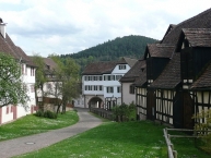
Heutige Nutzung
Das Kloster Hirsau ist für Besichtigungen geöffnet. Die Nebengebäude sind bewohnt oder beherbergen Abteilungen der Gemeindeverwaltung. Im wesentlich größten Teil der nutzbaren Gebäude befindet sich heute das Finanzamt Calw.
Informationen zu Urheber-Rechten | |
|---|---|
Rechte-Ausprägung / Lizenz | by-sa: CREATIVE COMMONS Namensnennung, Weitergabe unter gleichen Bedingungen |
Link zur Rechtebeschreibung | |
Text(e) übernommen von: |
Seite „Kloster Hirsau“. In: Wikipedia, Die freie Enzyklopädie. Bearbeitungsstand: 15. Januar 2021, 18:58 UTC. URL: https://de.wikipedia.org/w/index.php?title=Kloster_Hirsau&oldid=207681475 (Abgerufen: 17. Januar 2021, 16:16 UTC) |
übernommen / bearbeitet am | 17.01.2021
|
übernommen / bearbeitet durch |
|
![]()