
Cycle Tour Thuringia Cycle Loop
2. Etappe: Weimar - Naumburg - Nebra
![]()
Please wait - map data are loading
Added on 05 Jun 2013
last edited by ThimbleU on 08 Jul 2013
Cycle route metrics
ridden
Total distance in km
97
Cumulative elevation gain in m
880
Avg. slope uphill in %
0,91
Cumulative elevation loss in m
954
Total cycling hours
6,6
Avg. pace in km/h
14,7
Min. height
105
Max. height
259
Information about rights to the gps-track data | |
|---|---|
Rights owner | |
Rights characteristic / license | by-sa: CREATIVE COMMONS Attribution-ShareAlike |
Link to the description of the license | |
GPX file uploaded | by ThimbleU on 09 Jun 2013
|
Track points in total
1.534
Track points per km (avg)
16
Start/endpoint
Start location
Weimar, Thüringen, DE (237 m NHN)
End location
Nebra (Unstrut), Sachsen-Anhalt, DE (160 m NHN)
ridden on
06 Jun 2013
Weather
Schönster Sonnenschein, 20°, windstill
Accommodation
Hotel Schloss Nebra
Schlosshof 4-5
DE-06642 Nebra (Unstrut)
Signposting
von Weimar bis Kaatschen-Weichau |
|
von Glockenseck bis Karsdorf |
|


Properties
Der Ilmtal-Radweg verläuft zum größten Teil auf asphaltierten Nebenstraßen und eigens angelegtem asphaltiertem Radweg. 5,1 km verlaufen auf Wegen ohne Belag.
Der Saale-Radweg konnte aufgrund der Hochwasserlage gar nicht, der Unstrut-Radweg nur für 7 km befahren werden. Eine Aussage zur Oberflächenbeschaffenheit entfällt deshalb.
Slope Gradient Distribution
Travel report
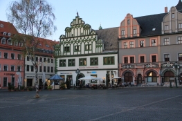
From the guest house we go again into the old town to take pictures with better light.
At the tourist information we try to find out in how far the Ilm Valley Cycle Route is affected by the floods. We decide to ride the bike path.
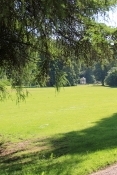
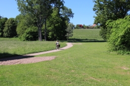
Directly behind the city the bike path runs through a park-like forest. The bike path was dredged just superficial, but we could ride it easily. From sewage treatment plant, the way was paved. Tiefurt was quickly reached. The castle is unimpressive, the park beautiful. In the valley between Tiefurt and Kleinkromsdorf the road was still slightly muddy, but could be traveled.
Information about copyright | |
|---|---|
Rights characteristic / license | by-sa: CREATIVE COMMONS Attribution-ShareAlike |
Link to the description of the license | |
taken over / edited on | 11 Jun 2013
|
taken over / edited by |
|
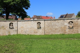
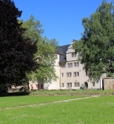
We pass through the castle park in Kromsdorf. At the enclosing wall dozens of stone busts are embedded. The castle building is unimposing, barely visible from the street.
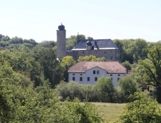
A few kilometers further on the opposite site of the Ilm valley Denstedt Castle is looking above the tops of trees. The bike path runs on asphalt road on the left bank of the river Ilm, always high enough above the river to be spared from the already largely receded floods. In the valley you can understand due to the muddy meadows and fields, how high the water level has been.
Information about copyright | |
|---|---|
Rights characteristic / license | by-sa: CREATIVE COMMONS Attribution-ShareAlike |
Link to the description of the license | |
taken over / edited on | 11 Jun 2013
|
taken over / edited by |
|
In Niederroßla the track bypasses the attractions of the place: the water castle and the baroque church of the village built in 1670. Of the backside of the water castle you can catch a glimpse through the trees.
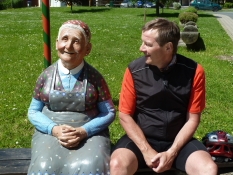
In Eberstedt we make a short stop at a walk-in sundial, where a "farmers wife" was already waiting on a bench beside it.
Information about copyright | |
|---|---|
Rights characteristic / license | by-sa: CREATIVE COMMONS Attribution-ShareAlike |
Link to the description of the license | |
taken over / edited on | 11 Jun 2013
|
taken over / edited by |
|
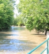
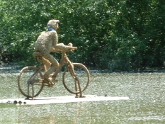
Soon we reach Bad Sulza. The sports ground is 50 cm under water. Ducks paddle leisurely on it. Just behind the municipal outdoor pool a "swimming cyclists" rides on a water left by the flood.
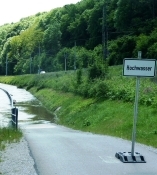
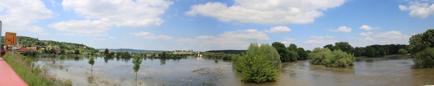
Three miles further we had to stop at an area of water. The Saale Cycle Path was flooded.
Information about copyright | |
|---|---|
Rights characteristic / license | by-sa: CREATIVE COMMONS Attribution-ShareAlike |
Link to the description of the license | |
taken over / edited on | 11 Jun 2013
|
taken over / edited by |
|
We cycle back to the road and follow it until Weichau. The bridge to Kaatschen is passable.
Passing wineries and vineyards we reach Kleinheringen. 700 meters further again a stop sign, an alternative route is not signposted. We ride up the hill via Tultewitz to Heiligenkreuz, nearly 150 meters of altitude in addition. On the street B88 we then roll down to Naumburg.
Information about copyright | |
|---|---|
Rights characteristic / license | by-sa: CREATIVE COMMONS Attribution-ShareAlike |
Link to the description of the license | |
taken over / edited on | 11 Jun 2013
|
taken over / edited by |
|
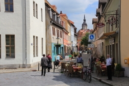
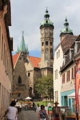
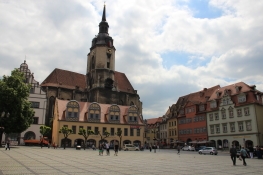
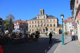
We arrive in the city via the Lindenring. First, we ride to the Duomo. Back to the Bürger-Stadt on the Steinweg. On the Herrenstraße we go to the impressive historic market square with the town hall on the west side, Wenceslas Church and the district court on the south side.
In the Salzstraße we provide us with a snack. Then we headed to the Unstrut Valley. Since the Unstrut bike path was flooded, we followed the Eislebener Straße to the B180.
Information about copyright | |
|---|---|
Rights characteristic / license | by-sa: CREATIVE COMMONS Attribution-ShareAlike |
Link to the description of the license | |
taken over / edited on | 11 Jun 2013
|
taken over / edited by |
|
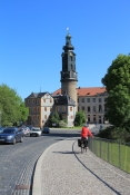
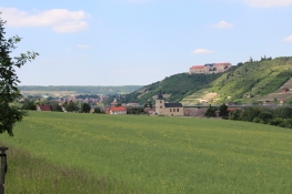
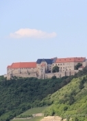
To Freyburg we cycled on the busy B180. The Neuenburg surmounts the valley powerfully. In Freyburg we cycled across the city, but the city has not caused us to linger.
Information about copyright | |
|---|---|
Rights characteristic / license | by-sa: CREATIVE COMMONS Attribution-ShareAlike |
Link to the description of the license | |
taken over / edited on | 11 Jun 2013
|
taken over / edited by |
|
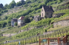
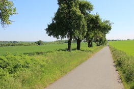
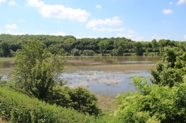
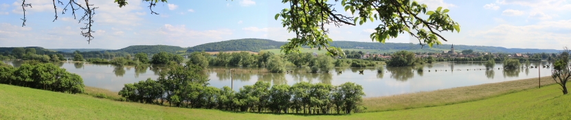
Following the road out of town we cycle along vineyards. Heavily terraced they pull up the slope. Because of the flooding we have to stay on the road, and have to pedal additional 60 meters in height. We see the lakes lying in the floodplain. Nice to look at, but certainly for affected proprietors connected with major damage.
Information about copyright | |
|---|---|
Rights characteristic / license | by-sa: CREATIVE COMMONS Attribution-ShareAlike |
Link to the description of the license | |
taken over / edited on | 11 Jun 2013
|
taken over / edited by |
|
Behind Karsdorf we must again ride on a main road, which we follow to Nebra. In Nebra we again have to cycle 40 meters of altitude to the Schlosshotel, where we had a very good hotel accommodation.
Information about copyright | |
|---|---|
Rights characteristic / license | by-sa: CREATIVE COMMONS Attribution-ShareAlike |
Link to the description of the license | |
taken over / edited on | 11 Jun 2013
|
taken over / edited by |
|