
Cycle Tour Wipper-Wupper-Ruhr-Emscher-Lippe
Travel report
Actions
![]()
Please wait - map data are loading
Added on 02 Dec 2015,
last edited by InduKult on 03 Dec 2015
Actions
Cycle route metrics
planned
ridden
Total distance in km
271
273
Cumulative elevation gain in m
1.060
911
Avg. slope uphill in %
0,39
0,33
Cumulative elevation loss in m
1.396
1.244
Total cycling hours
-
17,0
Avg. pace in km/h
-
16,1
Information about rights to the gps-track data | |
|---|---|
Rights owner | |
Rights characteristic / license | by-sa: CREATIVE COMMONS Attribution-ShareAlike |
Link to the description of the license | |
GPX file uploaded | by InduKult on 02 Dec 2015
|
Track points in total
3.314
3.319
Track points per km (avg)
12
12
Start/endpoint
Start location
Marienheide, Nordrhein-Westfalen, DE (363 m NHN)
End location
Wesel, Nordrhein-Westfalen, DE (27 m NHN)
Character
Auf ehemaligen Eisenbahnstrecken durch das Herz von NRW: von der Wipper durch das Bergische Land nach Wuppertal, steigungsarm und mit Tunnel zur Ruhr, durch das zentrale Ruhrgebiet nach Marl und Haltern und schließlich auf der ehemaligen "Rollbahn" parallel zur Lippe nach Wesel. Vielfache Verknüpfungspunkte mit dem Schienen-Regionalverkehr machen die Tour flexibel einteilbar:
Marienheide, Remscheid-Lennep, Opladen, Leichtlingen, Solingen Hbf und- Mitte, alle Wuppertaler Bahnhöfe, Hattingen, Bochum Hbf, Wanne-Eickel, Gelsenkirchen-Hassel, Marl-Mitte, Haltern, Dorsten, Wesel.
Es werden einige der neuen Bahntrassenradwege verknüpft:
- Balkantrasse Marienheide - Remscheid-Lennep -Opladen
- Korkenziehertrasse Solingen - Wuppertal
- Nordbahntrasse Wuppertal
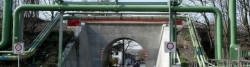
- Kohlenbahntrasse Wuppertal - Schee-Tunnel - Hattingen
- Springorum-Radweg Bochum-Dahlhausen - Altenbochum
- Erzbahntrasse Bochum-Westpark - Herne-Grimberg
- Zechenbahntrasse General Blumenthal Recklinhausen-Hochlar - Herten-Westerholt
- Zechenbahn Brassert - Viktoria Augusta in Marl
- "Rollbahn" Haltern - Dorsten - Wesel.
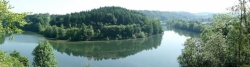
Insgesamt verlaufen ca. 170 km der Route auf Bahntrassen, oft auf Damm mit intergrierter Panoramafunktion.
Information about copyright | |
|---|---|
Rights characteristic / license | by-sa: CREATIVE COMMONS Attribution-ShareAlike |
Link to the description of the license | |
taken over / edited on | 02 Dec 2015
|
taken over / edited by |
|
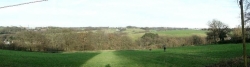
Landscape
Die gesamte Bandbreite der NRW-Landschaften, u.a.:
- Bergisches Hügelland
- kompakte und kleinteilige Bergische Städte
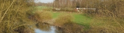
- Ruhr-Aue
- Siedlungen, Wäldchen, Brachen, Parks im zentralen Ruhrgebiet
- Halden und Siedlungen im nördlichen Ruhrgebiet
- Retortenstadt Marl
- münsterländische Parklandschaft an der Lippe.
Information about copyright | |
|---|---|
Rights characteristic / license | by-sa: CREATIVE COMMONS Attribution-ShareAlike |
Link to the description of the license | |
taken over / edited on | 02 Dec 2015
|
taken over / edited by |
|
Travel to and from ...
Mit dem Schienenregionalverkehr lässt sich die Tour nahezu beliebig in Etappen mit jeweiliger An- und Abreise aufteilen.
Sources of information
z.B. Radroutenplaner NRW
http://radservice.radroutenplaner.nrw.de/rrp/nrw/cgi?lang=DE
Connecting cycle path
Remarks
Selbst in Etappen bei täglicher An- und Abreise gefahren. Durch die mittlerweile großzügige Fahrrad-Mitnahme im NRW-Schienen-Regionalverkehr sollten Gruppentouren mit vier Leuten kein Problem sein.
Stages
Information about copyright | |
|---|---|
Rights owner | |
Rights characteristic / license | by-sa: CREATIVE COMMONS Attribution-ShareAlike |
Link to the description of the license | |
Image has been uploaded | by InduKult on 07 Dec 2015
|
79 km
Marienheide - Solingen
Information about copyright | |
|---|---|
Rights owner | |
Rights characteristic / license | by-sa: CREATIVE COMMONS Attribution-ShareAlike |
Link to the description of the license | |
Image has been uploaded | by InduKult on 07 Dec 2015
|
62 km
Solingen - Hattingen
Information about copyright | |
|---|---|
Rights owner | |
Rights characteristic / license | by-sa: CREATIVE COMMONS Attribution-ShareAlike |
Link to the description of the license | |
Image has been uploaded | by InduKult on 07 Dec 2015
|
59 km
Hattingen - Gelsenkirchen-Hassel
Information about copyright | |
|---|---|
Rights owner | |
Rights characteristic / license | by-sa: CREATIVE COMMONS Attribution-ShareAlike |
Link to the description of the license | |
Image has been uploaded | by InduKult on 07 Dec 2015
|
73 km
Gelsenkirchen-Hassel - Wesel
Beds4Cyclists, worth visiting and infrastructure
Name and address
Latitude / Longitude
Phone
Fax
Mobile
Type of accommodation
Rating for cyclists
Route km
Dist. to route
Elevation
0 km
2,1 km
394 m
0 km
0,1 km
Start oder Ziel des Balkantrassen-Radwegs an der Oberen Wipper. Direktverbindungen und Fahrradmitnahme mit der RB25 ab Köln.
Information about copyright | |
|---|---|
Rights characteristic / license | by-sa: CREATIVE COMMONS Attribution-ShareAlike |
Link to the description of the license | |
taken over / edited on | 04 Dec 2015
|
taken over / edited by |
|
0 km
4,6 km
257 m
Information about copyright | |
|---|---|
Rights owner | |
Rights characteristic / license | by-sa: CREATIVE COMMONS Attribution-ShareAlike |
Link to the description of the license | |
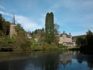
Image taken over from | https://commons.wikimedia.org/wiki/File:Schloss_Gimborn_und_Kirche_2010_SteDi2.jpg |
Image has been uploaded | by biroto-Redaktion on 21 Nov 2013
|
Information about copyright | |
|---|---|
Rights owner | |
Rights characteristic / license | by-sa: CREATIVE COMMONS Attribution-ShareAlike |
Link to the description of the license | |
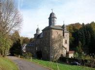
Image taken over from | https://commons.wikimedia.org/wiki/File:Schloss_Gimborn_2010_SteDi1.jpg |
Image has been uploaded | by biroto-Redaktion on 21 Nov 2013
|
Information about copyright | |
|---|---|
Rights owner | |
Rights characteristic / license | by-sa: CREATIVE COMMONS Attribution-ShareAlike |
Link to the description of the license | |
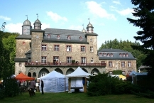
Image taken over from | https://commons.wikimedia.org/wiki/File:Marienheide_Gimborn_-_Schloss_Gimborn_11_ies.jpg |
Image has been uploaded | by biroto-Redaktion on 21 Nov 2013
|
Das Schloss Gimborn ist ein Schloss im Ortsteil Gimborn ![]() der Gemeinde Marienheide
der Gemeinde Marienheide ![]() im Oberbergischen Kreis in Nordrhein-Westfalen, Deutschland. Das Wasserschloss befindet sich in einem abseits gelegenen Tal der oberen Leppe
im Oberbergischen Kreis in Nordrhein-Westfalen, Deutschland. Das Wasserschloss befindet sich in einem abseits gelegenen Tal der oberen Leppe ![]() auf 278 Meter über NN. Seit 1874 ist die Anlage im Besitz der Freiherren von Fürstenberg zu Gimborn.
auf 278 Meter über NN. Seit 1874 ist die Anlage im Besitz der Freiherren von Fürstenberg zu Gimborn.
Gimborn wurde 1273 von dem Grafen von Berg an den Grafen von der Mark verpfändet und war ab 1631 Residenz der Grafschaft Gimborn-Neustadt des Hauses Schwarzenberg.
Von der ehemaligen Burganlage existieren nur noch Reste des Hauptturmes in der nordöstlichen Gebäudeecke des heutigen Haupthauses und der Umwehrungsmauer, auf der offenkundig das Nebenhaus und der quer zum Schloss angeordnete langgestreckte nördliche Wirtschaftsflügel (1741) aufgesetzt sind.
In späteren Bauphasen, nach Einführung der Feuerwaffen, wurden die Verteidigungsanlagen, die ihre militärische Bedeutung verloren hatten, zugunsten von repräsentativen Elementen zurück- oder umgebaut. Das heutige Schloss war zu keiner Zeit ein Wasserschloss; der Graben auf der Nordwestseite der Schlossanlage diente lediglich der Trockenhaltung des unter Straßenniveau gelegenen Geschosses.
Information about copyright | |
|---|---|
Rights characteristic / license | by-sa: CREATIVE COMMONS Attribution-ShareAlike |
Link to the description of the license | |
Input taken over from: |
Seite „Schloss Gimborn“. In: Wikipedia, Die freie Enzyklopädie. Bearbeitungsstand: 3. September 2013, 15:43 UTC. URL: http://de.wikipedia.org/w/index.php?title=Schloss_Gimborn&oldid=122193995 (Abgerufen: 21. November 2013, 17:37 UTC) |
taken over / edited on | 21 Nov 2013
|
taken over / edited by |
|
9 km
1,9 km
309 m
11 km
1,3 km
288 m
![]()