
Radtour Itinerario dei Santi
Geplante Tour: On the paths of S.Francesco and S.Benedetto
Aktionen
![]()
Bitte warten - Kartendaten werden geladen
Erstellt am 21.02.2021,
zuletzt geändert von agocurti am 21.02.2021
Aktionen
Strecken-Merkmale
geplant
gefahren
Gesamtlänge in km
716
0
Gesamthöhenmeter Aufstieg
12.450
0
Durchschn. Steigung Aufstieg %
1,74
-
Gesamthöhenmeter Abstieg
12.919
0
Informationen zu Rechten an den GPS-Track-Daten | |
|---|---|
Rechte-Inhaber | |
Rechte-Ausprägung / Lizenz | cc0: Public Domain keine Rechte vorbehalten |
Link zur Rechtebeschreibung | |
gpx-Datei hochgeladen | durch agocurti am 21.02.2021
|
Gesamtzahl Trackpoints
10.104
0
Trackpoint-Dichte per km
14
0
Endorte
Start
Perugia, Umbria, IT (481 m NHN)
Ziel
Rome, Lazio, IT (13 m NHN)
Fahrradfreundliche Unterkünfte, Sehenswertes und Infrastruktur
Name u. Anschrift
Breite / Länge
Tel.
Fax.
Mobile
Art d. Unterkunft
Radler-freund-lichkeit
Strecken-km
km zur Strecke
Höhe
0 km
0,0 km
497 m
Informationen zu Urheber-Rechten | |
|---|---|
Rechte-Inhaber | https://commons.wikimedia.org/w/index.php?title=User:Maurobifani |
Rechte-Ausprägung / Lizenz | by-sa: CREATIVE COMMONS Namensnennung, Weitergabe unter gleichen Bedingungen |
Link zur Rechtebeschreibung | |
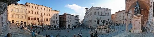
Bild übernommen aus | https://commons.wikimedia.org/wiki/File:Sabato_sera_in_piazza_IV_Novembre.jpg |
Bild hochgeladen | durch biroto-Redaktion am 13.10.2022
|
Informationen zu Urheber-Rechten | |
|---|---|
Rechte-Inhaber | |
Rechte-Ausprägung / Lizenz | by-sa: CREATIVE COMMONS Namensnennung, Weitergabe unter gleichen Bedingungen |
Link zur Rechtebeschreibung | |
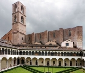
Bild übernommen aus | https://commons.wikimedia.org/wiki/File:Perugia,_museo_archeologico_nazionale,_chiostro_05,0.jpg |
Bild hochgeladen | durch biroto-Redaktion am 13.10.2022
|
Informationen zu Urheber-Rechten | |
|---|---|
Rechte-Inhaber | https://web.archive.org/web/20161031200034/www.panoramio.com/user/861544?with_photo_id=121026 |
Rechte-Ausprägung / Lizenz | by-sa: CREATIVE COMMONS Namensnennung, Weitergabe unter gleichen Bedingungen |
Link zur Rechtebeschreibung | |
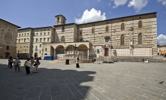
Bild übernommen aus | https://commons.wikimedia.org/wiki/File:Perugia,_Italy_-_panoramio_(51).jpg |
Bild hochgeladen | durch biroto-Redaktion am 13.10.2022
|
Informationen zu Urheber-Rechten | |
|---|---|
Rechte-Inhaber | https://commons.wikimedia.org/w/index.php?title=User:Bibopg79 |
Rechte-Ausprägung / Lizenz | by-sa: CREATIVE COMMONS Namensnennung, Weitergabe unter gleichen Bedingungen |
Link zur Rechtebeschreibung | |
Bild übernommen aus | |
Bild hochgeladen | durch biroto-Redaktion am 13.10.2022
|
Perugia is a city in the Italian region of Umbria. It has an important university that attracts many foreign students, is a major center of medieval art, has a stunningly beautiful central area and is home of the Umbria Jazz Festival. The city is also a major producer of chocolates.
Understand
The hills on which Perugia rises have been inhabited since ancient times. This is evidenced by numerous finds from prehistoric and early historical periods. Between the 6th and 5th centuries BC the area is occupied by the Etruscans, and in the 3rd century BC Perugia is the seat of Lucumonia (king and spiritual leader revered as a deity) and a member of the Etruscan Dodecapolis. Over the next two centuries, the city was alternately allied with Rome and then enemy again, until it fell in 40 BC finally subjugated by Octavian. In the Roman Empire, the city loses importance until it becomes almost an insignificant province. Around the 5th century there are first indications of a Perugia diocese and thus proof of the Christian organization and consolidation of the clergy. The defense of a siege by the Goths Totilas was led by Bishop Ercolano, but his defeat led to his martyrdom (548 AD). The following centuries are marked by changing fortunes, until the city finally falls into the hands of the Church. Around the 11th century, the rise to renewed dominance that lasted two centuries began. Wars against the neighboring cities, which are conquered and subdued, and alliances with the Church and the neighboring states make Perugia one of the most prosperous cities in Italy. In this heyday, however, internal disputes began that overshadowed the entire 15th century (Periodo delle Signorie, epoch of the nobility) and finally ended in 1540 (the Salt War) with the city's submission to church rule. The municipal courts are abolished and replaced by a papal governor, and the papal fortress of Rocca Paolina is built on the ruins of the Baglioni palaces. This situation lasted for more than three centuries until Perugia took part in the Risorgimento (national unification movement) in 1859, rebellion against the papal troops and bloodbaths, on September 14, 1860 the royal troops of Vittorio Emanuele II occupied the city, which from then on shares the changed fate of the Italian state.
See
- ⊙Rocca Paolina. It was a Renaissance fortress, built in 1540-1543 for pope Paul III to designs by Antonio da Sangallo the Younger. The escalators from the lower town lead up through the remains of this fortress. It was built on top of medieval streets, which were used as foundations, and before coming out into daylight at Piazza Italia you go through some of these medieval streets covered with brick ceilings when the fortress was built. Little now remains of the fortress itself. Free admission.
 (updated May 2019)
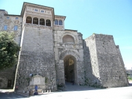
 - ⊙Porta Marzia (Marzia Gate). This is an Etruscan city gate built in the 3rd century BC and much later incorporated into the city walls. It is close to the remains of the Paolina Fortress.
- ⊙Arco Etrusco (Etruscan Arch). This is an Etruscan city gate built in the 3rd century BC. With its 11 m. height and because of its excellent state of preservation, it is considered as the most impressive of all the ancient Etruria..
- ⊙Fontana Maggiore. This large medieval fountain is found between the cathedral and the Palazzo dei Priori. It was made between 1277 and 1278 by Nicola and Giovanni Pisano as part of Perugia's celebrations of its independence. On the twenty-five sides of the basin are sculptures representing prophets and saints, the work of the seasons, signs of the zodiac, Bible scenes and events from Roman history.
- ⊙Perugia Cathedral (Cattedrale di San Lorenzo). This has an unusual layout for Italian churches in that the side rather than the front entrance faces the main square. There have been many churches on the site: this one was last worked on around 1490. But finished it was not, as can be clearly seen from the unfinished façade facing the square. This side includes the Loggia di Braccio, an early Renaissance structure. Under it a section of Roman wall and the basement of the old bell tower can be seen. Also found here is the 1264 Pietra della Giustizia ("Justice Stone") with which Perugia announced that it had repaid its public debt, a not inconsiderable feat. Also noteworthy is the external pulpit from which Saint Bernardine of Siena, a virulently anti-homosexual priest, would preach.
- Capitular Museum (Museo del Capitolo della Cattedrale di San Lorenzo), in the cloister of St. Lorenzo Cathedral. Religious paintings.
- Archeologic Area of the Cathedral of San Lorenzo. Tu-Su 11:00 and 15:30. €8. (updated May 2019)
- ⊙Palazzo dei Priori (Town Hall) (Opposite the side of the cathedral, with its main entrance on Corso Vannucci). This is a large building in Italian Gothic style built in the early 1300s. On the side facing the piazza are a griffin, the emblem of Perugia, a 14th-century bronze lion, and some chains, from where the keys of Siena were displayed after victory over the Sienese in 1358. Inside is the impressive meeting room, the Sala dei Notari. On the second floor is the Municipal Library. The building also houses the National Gallery of Umbria.
- Galleria Nazionale dell’Umbria (National Gallery of Umbria) (inside the Palazzo dei Priori). Tu-Sa 08:30-19:30, closed Mondays, 1st January, 1st May, 25 December. €8.
The collection consists of paintings from the 13th to the 19th century, including artists such as Perugino, Nicola e Giovanni Pisano, Beato Angelico, Benozzo Gozzoli, and Pinturicchio. (updated Apr 2019) - Nobile Collegio della Mercanzia (inside the Palazzo dei Priori).
- Nobile Collegio del Cambio, Corso Vannucci, 25 (inside the Palazzo dei Priori). M-Sa 09:00-12:30; 14:30-17:30.
Displays various works of art. €4.50. (updated May 2019)
- Galleria Nazionale dell’Umbria (National Gallery of Umbria) (inside the Palazzo dei Priori). Tu-Sa 08:30-19:30, closed Mondays, 1st January, 1st May, 25 December. €8.
- ⊙Etruscan Well (Pozzo Etrusco), Piazza Danti 18 (To the right, just past the front entrance of the cathedral). 11:00-13:30, 14:30-17:00, longer in the summer months.
Damp and dark but an excellent way of appreciating the skills of 3rd-century BC Etruscan architects. €3. (updated May 2019) - ⊙San Domenico, on Corso Cavour, down the hill to the southeast of Corso Vannucci.
It is a Gothic church whose three aisles were a model for the design of the later cathedral of San Lorenzo. San Domenico has faced many problems in the past. Soon after its completion, the upper section was found to be unstable and had to be demolished. In 1614 and 1615 other parts collapsed. The rebuilt church was consecrated in 1632.
Open: 7:00 am - 12:00 pm 4:00 pm - 7:00 pm, free. (updated Oct 2022) - ⊙San Pietro, Borgo XX Giugno, 74.
About 1 km further along Corso Cavour after San Domenico, this church and abbey is well filled with fine works of art, including by Perugino. Interesting hexagonal bell tower. See too the medieval garden through the hall off the courtyard.
Open: Mo-Sa 10:00 am – 1:00 pm / 2:00 pm – 6:00 pm. €6, €3 reduced. (updated Oct 2022)
Museums
Perugia City Museum Card allows access to any 5 museums of the following 10 ones: San Severo Chapel, National Gallery of Umbria, Volumni Hypogeum, National Archaeological Museum of Umbria, Capitolar Museum, Nobile Collegio del Cambio, Nobile Collegio della Mercanzia, Palazzo Baldeschi al Corso, Museum of Palazzo della Penna, Etruscan Well. It also allows reduced admission to Archeologic Area of the Cathedral of San Lorenzo, Museum of the Academy of fine Arts, Palazzo Sorbello House Museum, Templar Complex of San Bevignate, in addition to discounts at featured restaurants. It's valid for 48 hours and costs €14 for adults and €10 for students (May 2019).
- ⊙Academy of Fine Arts (Accademia di belle arti Pietro Vannucci), At the bottom of Via dei Priori in the former convent of San Francesco al Prato. Sa 14:30-17:00, and Su 10:30-13:00 & 14:30-17:00.
A small but excellent collection of plaster casts of famous sculptures: the Dying Gaul, two of Michelangelo’s Prisoners, the Laocoön and His Sons, and even the reconstructed façade of the Roman temple at Clitunno. The Pinacoteca is not overwhelming, with an interesting selection from the Academy's four-centuries-old collection. €5, €3 reduced. (updated Jan 2016) - ⊙Museo Archeologico Nazionale dell'Umbria, Piazza Giordano Bruno, 10. Open 08:30 – 19:30. €5. (updated Apr 2019)
- ⊙Civic Museum at Palazzo della Penna. Contemporary art museum.
€5. (updated May 2019) - ⊙Chapel of San Severo, Piazza Raffaello (Next to the Church of San Severo).
Houses the only fresco by Raphael that has remained in Perugia. - ⊙Complesso templare di San Bevignate, Via Enrico dal Pozzo, 145 (2 km east of the city). Open Tuesday - Sunday 10:00–13:00, 15:00-18:00.
Ex S. Bevignate church, converted into a museum now. (updated May 2019) - ⊙Baldeschi al Corso palace (Palazzo Baldeschi al Corso), Corso Vannucci, 66.
Informationen zu Urheber-Rechten | |
|---|---|
Rechte-Ausprägung / Lizenz | by-sa: CREATIVE COMMONS Namensnennung, Weitergabe unter gleichen Bedingungen |
Link zur Rechtebeschreibung | |
Text(e) übernommen von: |
Wikivoyage contributors, 'Perugia', Wikivoyage, The FREE worldwide travel guide that anyone can edit, 27 September 2022, 17:59 UTC, https://en.wikivoyage.org/w/index.php?title=Perugia&oldid=4528147 |
übernommen / bearbeitet am | 13.10.2022
|
übernommen / bearbeitet durch |
|
0 km
0,0 km
483 m
Öffnungszeiten
Mo-Su 09:00-19:00
19 km
3,2 km
198 m
25 km
0,0 km
420 m
Informazioni E Accoglienza Turistica Di Assisi
IT-06081 Assisi
Touristen Information
Öffnungszeiten
Mo-So 09:00-19:00
25 km
0,0 km
421 m
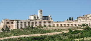
Informationen zu Urheber-Rechten | |
|---|---|
Rechte-Inhaber | |
Rechte-Ausprägung / Lizenz | by-sa: CREATIVE COMMONS Namensnennung, Weitergabe unter gleichen Bedingungen |
Link zur Rechtebeschreibung | |
Bild übernommen aus | https://commons.wikimedia.org/wiki/File:Basilica_di_San_Francesco,_May_2017.jpg |
Bild hochgeladen | durch biroto-Redaktion am 13.10.2022
|
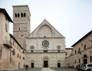
Informationen zu Urheber-Rechten | |
|---|---|
Rechte-Inhaber | |
Rechte-Ausprägung / Lizenz | by-sa: CREATIVE COMMONS Namensnennung, Weitergabe unter gleichen Bedingungen |
Link zur Rechtebeschreibung | |
Bild übernommen aus | https://commons.wikimedia.org/wiki/File:Facade_and_tower_-_San_Rufino_-_Assisi_2016.jpg |
Bild hochgeladen | durch biroto-Redaktion am 13.10.2022
|
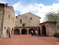
Informationen zu Urheber-Rechten | |
|---|---|
Rechte-Inhaber | |
Rechte-Ausprägung / Lizenz | by-sa: CREATIVE COMMONS Namensnennung, Weitergabe unter gleichen Bedingungen |
Link zur Rechtebeschreibung | |
Bild übernommen aus | https://commons.wikimedia.org/wiki/File:San_Damiano_(Assisi)_01.JPG |
Bild hochgeladen | durch biroto-Redaktion am 13.10.2022
|
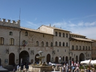
Informationen zu Urheber-Rechten | |
|---|---|
Rechte-Inhaber | https://commons.wikimedia.org/w/index.php?title=User:Diego_Baglieri |
Rechte-Ausprägung / Lizenz | by-sa: CREATIVE COMMONS Namensnennung, Weitergabe unter gleichen Bedingungen |
Link zur Rechtebeschreibung | |
Bild übernommen aus | https://commons.wikimedia.org/wiki/File:Residenza_municipale_-_Assisi_05.jpg |
Bild hochgeladen | durch biroto-Redaktion am 13.10.2022
|
Assisi is a small medieval town of about 25,000 people perched on a hill in Umbria, the heart of Italy. Famous as the birthplace of St. Francis, Assisi holds religious, historical, and artistic significance. Periodical exhibits and fairs enrich the visitor's experience.
See
Definitely take the time to walk among Assisi's medieval houses and shops. Most of the cobblestone streets and alleys will take you to the basilica of St. Francis.
The basilica of St. Francis is only one of many beautiful churches in Assisi. The cathedral of San Rufino, the basilica of Santa Chiara, and the Chiesa Nuova are also worth a visit. Take the time to hike up to the top of the hill above Assisi and explore the castle - ⊙"La Rocca" - where Frederick Barbarossa spent his childhood. From here you can overlook the town and the valley below. Visit the tiny church of St. Stefano, go up a few stairs, and look back downwards for the most picturesque spot of this beautiful little town.
- ⊙Basilica of San Francesco d'Assisi
 . Basilica was completed in 1253. The walls and ceilings of the upper church are embellished with frescoes of the Giotto school; the lower sanctuary contains the tomb of St. Francis. It's a good idea to rent the audio guide to appreciate the artistic and historical significance of this unique church. Please be quiet as you visit this multi-level structure as it still is a place of prayer for many.
 - ⊙Treasury Museum of the Basilica of San Francesco (Museo del Tesoro della Basilica di San Francesco), Piazza San Francesco 1. 10.00-13.00; 14.00-17.30. Free admission. (updated May 2019)
- ⊙San Rufino Cathedral. It has probably the most beautiful façade of all the churches in town. If you have some time to spare visit the museum.
- ⊙Assisi Diocesan Museum (Museo diocesano e cripta di San Rufino), Palazzo dei Canonici, Piazza San Rufino 3 (attached to San Rufino Cathedral). March-October 10:00-13:00 – 15:00-18:00. (updated May 2019)
- Following Via San Rufino (walking down in front of the Cathedral) you arrive to ⊙Piazza del Comune, the center of the town. There is a small fountain known as the "lions fountain". There are two main attractions on the Piazza: the "Palazzo del Capitano del Popolo" with the clock tower and the beautiful church of Santa Maria Sopra Minerva (St. Mary over Minerva), with its impressive roman columns. Assisi, being an old roman town, had its own temple dedicated to Minerva, the goddess of wisdom. With the arrival of Christianity the temple was transformed into a Catholic church and the Virgin Mary was promoted above pagan wisdom. The church was completely remodeled in the early 1990s and stands in stark contrast to the exterior. In Piazza del Comune you find also the Tourist Information Center.
- From the "Lions Fountain" find the street called "Corso Mazzini". Here you will find many interesting shops of all sorts. At the end of the street you'll find and archway and after that you will see the lovely St. Claire's Basilica, where the original crucifix, that spoke to Saint Francis, is found. There is a lovely piazza in front of the Church, with wonderful views of the valley. Morning and Evening prayer is beautiful here, with the choir of cloistered Poor Clare nuns singing.
- Re-tracing your steps you can go back to Piazza del Comune, passing on your left a little street that takes you to "Chiesa Nuova", a very spiritual little church built over to what is said to be Francis' original home.
- From Piazza del Comune you have two options to reach Saint Francis' Basilica:
- a) the street to your right is "Via San Paolo", and it will eventually lead you to the Basilica. This is a slightly longer way to get there and not so crowded, sometimes there is no one around, even on busy days! After you walk a little on Via San Paolo turn to your left when you see some steps and a fresco on the wall, follow the steps down until you get to the small church of St. Stephen (Santo Stefano). This is a real jewel, not known to many and skipped by the majority of "running pilgrims". Even if for 5 minutes it is a must-see.
- b) the street to your left from Piazza del Comune is called "Via Portica". This is the usual and shorter way to go to the Basilica of Saint Francis. There are plenty of shops. On your left you will eventually find the Metastasio theater, with an continual exhibit about St. Clare. After a short while you pass an archway and arrive to "Via San Francesco". A little walk and to your left you will see a little chapel called the "Oratorio dei Pellegrini" (the Pilgrim's Chapel). It only opens for a few hours during the day when it is open there is almost always Eucharistic adoration. Inside this room you will find some of the most beautiful frescos of the town. In this same street to your right you can find some very interesting museums.
- At the end of the street you will find the ⊙Basilica of St. Francis, with everything to discover. Start at the upper Basilica. Make sure you make it to the lower church and down the stairs to the Tomb of Saint Francis. This is one of the most spiritually powerful places in Assisi.
- When you finish your visit of the Basilica you will exit on the lower part, in front of Piazza San Francesco. Walk down the Piazza, cross the archway and walk down Via Frante Elia. When you arrive to the bottom of the street to your left you will see a big Church, ⊙San Pietro. This is another "must see" of the city that is many times ignored. Differently to other churches in town, the interior is more beautiful than the exterior.
If you have more time, these are some hints:
- ⊙San Damiano. The little church of San Damiano is outside the walls of the city, halfway down the hill, but easily accessible from Porta Nuova, near St. Clare's Basilica. According to the saint's biographers, it was here that St. Francis received his message "to rebuild the church." This is one of the most "franciscan" places in town and it is definitely worth the small detour from the centre. If you are staying in for some days they have a lovely 07:30 morning mass, with beautiful music. (updated May 2019)
- ⊙Santa Maria Maggiore Church, near "Piazza del Vescovado". In a little hidden angle of the town, a beautiful well kept Church (don't be cheated by its unassuming façade). Going down the hill a little look for the monastery of St Quirico - early in the morning and at 6 pm the Poor Clare nuns have morning and evening prayer - differently to the Poor Clares in Sta Chiara (who are hidden from view), you can actually see the sisters during prayers and at the end even exchange a couple of words.
- ⊙Oratorio San Francesco Piccolino. From Corso Mazzini you follow some little steps and arrive to a very little chapel where the legend says Francis was actually born.
- ⊙Rocca Maggiore.A lovely site with wonderful views. A good climb so be prepared for a walk. The structure has been restored and besides the wonderful architecture and the views you can also see an exhibition based on the Calendimaggio, the spring festival of the city.
- On the "back" of Piazza del Comune you can find a lovely and basically unknown area of the town, with beautiful houses, lovely views, some shrines for Our Lady and one or two cats having a nap. Look for the unconsecrated ⊙Church of Sta Maria delle Rose.
- ⊙Chiesa di Santa Margherita (Church of Saint Margaret). Among the little streets in front of St Francis Basilica. You have lovely views of the Basilica from the small Piazza.
- ⊙Indios Missionary Museum (MUMA).
- ⊙Gallery of Contemporary Art of the Pro Civitate Christiana (Galleria d’Arte Contemporanea della Pro Civitate Christiana), Via degli Ancajani 3.
Informationen zu Urheber-Rechten | |
|---|---|
Rechte-Ausprägung / Lizenz | by-sa: CREATIVE COMMONS Namensnennung, Weitergabe unter gleichen Bedingungen |
Link zur Rechtebeschreibung | |
Text(e) übernommen von: |
Wikivoyage contributors, 'Assisi', Wikivoyage, The FREE worldwide travel guide that anyone can edit, 2 March 2022, 00:22 UTC, https://en.wikivoyage.org/w/index.php?title=Assisi&oldid=4398917 |
übernommen / bearbeitet am | 12.10.2022 - 13.10.2022
|
übernommen / bearbeitet durch |
|
![]()