
Radweg Land’s End nach John o’Groats
Aktionen
![]()
Bitte warten - Kartendaten werden geladen
Erstellt am 22.02.2017,
zuletzt geändert von biroto-Redaktion am 13.01.2021
Aktionen
Strecken-Merkmale
Gesamtlänge in km
1.933
Informationen zu Rechten an den GPS-Track-Daten | |
|---|---|
Rechte-Inhaber | |
Rechte-Ausprägung / Lizenz | cc0: Public Domain keine Rechte vorbehalten |
Link zur Rechtebeschreibung | |
gpx-Datei hochgeladen | durch biroto-Redaktion am 13.01.2021
|
Gesamtzahl Trackpoints
32.279
Trackpoint-Dichte per km
17
Endorte
Start
Mayon, England, GB (42 m NHN)
Ziel
John o' Groats, Scotland, GB (23 m NHN)
Charakter
Die kultige und fantastische Fahrt von Land's End nach John o'Groats deckt fast 2.000 km auf dem National Cycle Network ab, auf Straßen und auf verkehrsfreien Strecken. Die Route führt durch einige der malerischsten Landschaften in England und Schottland.
Informationen zu Urheber-Rechten | |
|---|---|
Rechte-Ausprägung / Lizenz | by-sa: CREATIVE COMMONS Namensnennung, Weitergabe unter gleichen Bedingungen |
Link zur Rechtebeschreibung | |
übernommen / bearbeitet am | 23.02.2017
|
übernommen / bearbeitet durch |
|
Fahrradfreundliche Unterkünfte, Sehenswertes und Infrastruktur
Name u. Anschrift
Breite / Länge
Tel.
Fax.
Mobile
Art d. Unterkunft
Radler-freund-lichkeit
Strecken-km
km zur Strecke
Höhe
0 km
0,3 km
37 m
Informationen zu Urheber-Rechten | |
|---|---|
Rechte-Inhaber | |
Rechte-Ausprägung / Lizenz | by-sa: CREATIVE COMMONS Namensnennung, Weitergabe unter gleichen Bedingungen |
Link zur Rechtebeschreibung | |
Bild übernommen aus | https://commons.wikimedia.org/wiki/File:Land's_End,_Cornwall,_England.jpg |
Bild hochgeladen | durch biroto-Redaktion am 17.04.2017
|
Informationen zu Urheber-Rechten | |
|---|---|
Rechte-Inhaber | |
Rechte-Ausprägung / Lizenz | by: CREATIVE COMMONS Namensnennung |
Link zur Rechtebeschreibung | |
Bild übernommen aus | |
Bild hochgeladen | durch biroto-Redaktion am 17.04.2017
|
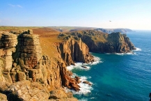
Land's End is the most Southwesterly point in Britain and part of Cornwall in the South West. It is not a town or village but rather a former small holding which now has an Visitor Complex with a Hotel, Visitor attractions and is well known for being the starting/ending point for the Land's End to John o'Groats ![]() journey.
journey.
Understand
Land's End's main represents both the starting and ending points of the longest journey in Great Britain, Land's End to John O'Groats. Consequently, it is known as "The First and Last", due to its position at the extremity of the UK. It is an atmospheric, dramatic piece of coastline steeped in history and romance.
See
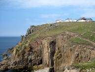
- ⊙Lands End Visitor's Centre, Sennen, TR19 7AA, ☎ +44 8717 200044.
Do
- There is a Complex of Attractions on the site. A professional photographer takes photos of you in front of the signpost showing your hometown's distance (see photo above). He will charge you around £10 for the photos. There is a fence around the signpost, but you can, and many people do, just take their own photos standing in front of the fence.
- Walk East along the coast to the first promontory. The sea arch is visible along with the extraordinary rock formations in this area (weathered Granite). The coast path continues on to Porthgwarra past various coves, many caves, another sea arch and possibly some of the most dramatic coastline in the entire UK. An extended walk will reach Porthcurno where there is a bus service.
Informationen zu Urheber-Rechten | |
|---|---|
Rechte-Ausprägung / Lizenz | by-sa: CREATIVE COMMONS Namensnennung, Weitergabe unter gleichen Bedingungen |
Link zur Rechtebeschreibung | |
Text(e) übernommen von: |
Wikivoyage contributors, 'Land's End', Wikivoyage, The FREE worldwide travel guide that anyone can edit, 15 January 2019, 19:45 UTC, <https://en.wikivoyage.org/w/index.php?title=Land%27s_End&oldid=3707144> [accessed 24 January 2019] |
übernommen / bearbeitet am | 17.04.2017 - 24.01.2019
|
übernommen / bearbeitet durch |
|
16 km
0,0 km
94 m
24 km
0,2 km
12 m
Penzance is the most south-westerly town in Cornwall. Famous for its association with the Gilbert and Sullivan opera The Pirates of Penzance, the town is an ideal base for exploring the Penwith area of Cornwall. It is increasingly attracting those interested in cultural tourism due to its long association with the arts.
Penzance is also the home of a major link to and from the Isles of Scilly ![]() via the spring and summer-only ferry.
via the spring and summer-only ferry.
See
Throughout the town there are numerous examples of Regency and Georgian Architecture.
Penzance is home to a lengthy promenade built in the 1840s. Admire the cool white art deco Jubilee Pool and see the "ballet of the waves" as they crash into the sea wall (particularly spectacular opposite the handsome Queen's Hotel which is worth visiting for its splendid paintings from Newlyn School artists.)
Penzance has an array of interesting buildings including the Egyptian House, built in an Egyptian style and the Market House, described as one of the finest examples of regional architecture in the UK. The walk down Chapel Street towards St Mary's Church and the harbour is a delight! Look for the quaint Turk's Head Inn and the pirate on the roof of the Admiral Benbow pub!
- ⊙ Morrab Gardens (in the centre of town). a fine example of a sub-tropical public garden.
- ⊙St Johns Hall (Penzance's Town Hall). is one of the largest purely granite structures in the world
- ⊙Penlee House Museum. Home to a wide selection of paintings from the Newlyn School of painters including Stanhope Forbes.

Do
- Hike town trails. The Penzance, Newlyn and Mousehole town trail maps are available from the Penzance Town Council offices and local outlets. These planned walks are an excellent way to see the unique history of the area.
- Marine Discovery. Wildlife boat trip for a dolphin-watching and basking shark-watching sea safari tour on a sailing catamaran.
- Morrab Library. For those interested in all things book-related, Penzance has an excellent private library consisting 60K+ volumes plus archives and photographic collections. Think floor-to ceiling book cases, leather chairs, and sea views. A book-lover's paradise. Day membership available at £3. The library is located within the Morrab Gardens. (updated Feb 2017)
- Western Discoveries. Guided walks. Historical and folklore-based tours of Penwith's ancient monuments.
Eat
For those seeking to eat a Cornish pasty, Lavenders and Pellows are excellent choices. Countless other bakeries, shops and cafés also sell them, hot and cold. (Tip: it is correct to eat pasties from the end, not in the middle!)
- ⊙Admiral Benbow, 46 Chapel St, ☎ +44 1736 363448. Pub with restaurant offering traditional British food. Huge collection of historic maritime objects on display in every conceivable location.
- ⊙Archie Browns, Bread St, ☎ +44 1736 362828. Excellent range of healthily-made home-cooked meals, cakes and refreshments available in the café upstairs. Walk into the shop, turn right, and go up the stairs. The café is also an art gallery.
- ⊙Blacks Dining Room & Bar, 12 Chapel St (Half-way down Chapel Street, you can't miss it.), ☎ +44 1736 369729. Freshly sourced local Cornish produce for lunchtime and evening dining. Fish is from the nearby fish market in Newlyn.
- ⊙Lavenders, 6A Alverton Street, TR18 2QW (Alverton Street). Excellent Cornish pasties. A large pasty is very large. Do not expect to do much after eating one!
- ⊙Market Plaice Fish Bar. Serving the community with fish & chips for 50 years.
- ⊙Waterside Meadery, Wharf Rd, Penzance TR18 4AB, ☎ +44 1736 364424. 18:00-22:00. Meaderies are medieval-themed restaurants which have become a Cornish tradition. They serve simple food, such as "chicken in the rough" (chicken and chips in a basket), and serve jugs of mead and other fruit wines, all produced locally. No bookings, so you may have to queue. There are other meaderies in the area at Newlyn and Trewellard, as well as farther afield in Redruth and Newquay. (updated Feb 2017)
- ⊙Pellows, 95, Market Jew St, Penzance, TR18 2LE (Market Jew St), ☎ +44 1736 331582. Excellent Cornish pasties, both made and baked on the premises. Also a good old-fashioned bakers selling bread, buns and cakes made on the premises. Try the Cornish 'hevva cake' or saffron buns.
- ⊙The Cornish Barn (The Cornish Barn), 20 Chapel Street, TR18 4AW (At the lower end of Chapel Street, close to the Methodist Chapel.), ☎ +44 1736 874418. 18:00 - 23:00. American style food in a contemporary setting (think burgers, buttermilk chicken, gourmet hot dogs, craft beer and cocktails in jars). Very trendy and popular, with a newly opened garden (May 2015) at the rear with an outdoor bar. Meals from £5.
Informationen zu Urheber-Rechten | |
|---|---|
Rechte-Ausprägung / Lizenz | by-sa: CREATIVE COMMONS Namensnennung, Weitergabe unter gleichen Bedingungen |
Link zur Rechtebeschreibung | |
Text(e) übernommen von: |
Wikivoyage contributors, 'Penzance', Wikivoyage, The FREE worldwide travel guide that anyone can edit, 18 March 2017, 21:34 UTC, <https://en.wikivoyage.org/w/index.php?title=Penzance&oldid=3169416> [accessed 22 April 2017] |
übernommen / bearbeitet am | 22.04.2017 - 04.12.2018
|
übernommen / bearbeitet durch |
|
28 km
1,1 km
6 m
Informationen zu Urheber-Rechten | |
|---|---|
Rechte-Inhaber | |
Rechte-Ausprägung / Lizenz | by-sa: CREATIVE COMMONS Namensnennung, Weitergabe unter gleichen Bedingungen |
Link zur Rechtebeschreibung | |
Bild übernommen aus | https://commons.wikimedia.org/wiki/File:St_Michael's_Mount_(7443).jpg |
Bild hochgeladen | durch biroto-Redaktion am 23.04.2017
|
Informationen zu Urheber-Rechten | |
|---|---|
Rechte-Inhaber | |
Rechte-Ausprägung / Lizenz | by-sa: CREATIVE COMMONS Namensnennung, Weitergabe unter gleichen Bedingungen |
Link zur Rechtebeschreibung | |
Bild übernommen aus | |
Bild hochgeladen | durch biroto-Redaktion am 23.04.2017
|
Informationen zu Urheber-Rechten | |
|---|---|
Rechte-Inhaber | |
Rechte-Ausprägung / Lizenz | by-sa: CREATIVE COMMONS Namensnennung, Weitergabe unter gleichen Bedingungen |
Link zur Rechtebeschreibung | |
Bild übernommen aus | |
Bild hochgeladen | durch biroto-Redaktion am 23.04.2017
|
Informationen zu Urheber-Rechten | |
|---|---|
Rechte-Inhaber | |
Rechte-Ausprägung / Lizenz | by: CREATIVE COMMONS Namensnennung |
Link zur Rechtebeschreibung | |
Bild übernommen aus | https://commons.wikimedia.org/wiki/File:St.Michael's_Mount,_Marazion,_Cornwall_(19239458051).jpg |
Bild hochgeladen | durch biroto-Redaktion am 23.04.2017
|
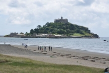
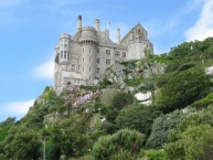
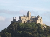
St Michael's Mount (Cornish: Karrek Loos yn Koos, meaning "hoar rock in woodland") is a small tidal island in Mount's Bay, Cornwall. The island is a civil parish and is linked to the town of Marazion by a man-made causeway of granite setts, passable between mid-tide and low water. The population of this parish in 2011 was 35. It is managed by the National Trust, and the castle and chapel have been the home of the St Aubyn family since approximately 1650. The earliest buildings, on the summit, date to the 12th century.
Its Cornish language name – literally, "the grey rock in a wood" – may represent a folk memory of a time before Mount's Bay was flooded, indicating a description of the mount set in woodland. Remains of trees have been seen at low tides following storms on the beach at Perranuthnoe ![]() . Radiocarbon dating established the submerging of the hazel wood at about 1700 BC.
. Radiocarbon dating established the submerging of the hazel wood at about 1700 BC.
Historically, St Michael's Mount was a Cornish counterpart of Mont Saint-Michel ![]() in Normandy, France (with which it shares the same tidal island characteristics and the same conical shape, in spite of being much smaller), when it was given to the Benedictine religious order of Mont Saint-Michel by Edward the Confessor in the 11th century.
in Normandy, France (with which it shares the same tidal island characteristics and the same conical shape, in spite of being much smaller), when it was given to the Benedictine religious order of Mont Saint-Michel by Edward the Confessor in the 11th century.
St Michael's Mount is one of forty-three (unbridged) tidal islands that one can walk to from mainland Britain. Part of the island was designated as a Site of Special Scientific Interest in 1995 for its geology.
The island today
The chapel of St Michael, a fifteenth-century building, has an embattled tower, one angle of which is a small turret, which served for the guidance of ships. The chapel is extra-diocesan and continues to serve the Order of St John by permission of Lord St Levan. Chapel Rock, on the beach, marks the site of a shrine dedicated to the Virgin Mary, where pilgrims paused to worship before ascending the mount. Many antiquities, comprising plate armour, paintings and furniture, are preserved at the castle. Several houses are built on the hillside facing Marazion, and a spring provides a natural flow of water. There is a row of eight houses at the back of the present village; built in 1885 they are known as Elizabeth Terrace. Some of the houses are occupied by staff working in the castle and elsewhere on the island. The mount's cemetery (currently no public access) contains the graves of former residents of the island and several drowned sailors. There are also buildings that were formerly the steward's house, a changing-room for bathers, the stables, the laundry, a barge house, a sail loft (now a restaurant), and two former inns. A former bowling green adjoins one of the buildings.
The harbour, enlarged in 1823 to accommodate vessels of up to 500 tonnes deadweight, has a pier dating back to the 15th century which has also been renovated. Queen Victoria disembarked from the royal yacht at St Michael's Mount in 1846, and a brass inlay of her footstep can be seen at the top of the landing stage. King Edward VII's footstep is also visible near the bowling green. In 1967 the Queen Mother entered the harbour in a pinnace from the royal yacht Britannia.
Another noteworthy point of interest on the island is its underground railway, which is still used to transport goods from the harbour up to the castle. It was built by miners around 1900, replacing the pack horses which had previously been used. Its steep gradient renders it unsafe for passenger-use, thus The National Trust has made it out-of-bounds for public access.
The causeway between the mount and Marazion was improved in 1879 by raising it by one foot (30 cm) with sand and stones from the surrounding area. Repairs were completed in March 2016 following damage from the 2014 winter storms. Some studies indicate that any rise in ocean waters as well as existing natural erosion would put some of the Cornwall coast at risk, including St. Michael's Mount.
Informationen zu Urheber-Rechten | |
|---|---|
Rechte-Ausprägung / Lizenz | by-sa: CREATIVE COMMONS Namensnennung, Weitergabe unter gleichen Bedingungen |
Link zur Rechtebeschreibung | |
Text(e) übernommen von: |
Wikipedia contributors, 'St Michael's Mount', Wikipedia, The Free Encyclopedia, 9 April 2017, 17:48 UTC, <https://en.wikipedia.org/w/index.php?title=St_Michael%27s_Mount&oldid=774621289> [accessed 23 April 2017] |
übernommen / bearbeitet am | 23.04.2017
|
übernommen / bearbeitet durch |
|
Öffnungszeiten
The garden is open Sunday - Friday (10:30-17:00).
The garden is open 17 April – 30 June, Monday - Friday (10:30-17:00), 6 July – 1 September, Thursday & Friday (10:30-17:30) & 7 - 29 September, Thursday and Friday (10:30-17:00).
38 km
4,8 km
7 m
Öffnungszeiten
April
- Monday to Saturday: 10am - 3pm
- Sunday: Closed
May
- Monday to Saturday: 10am - 4pm
- Sunday: 10am - 3pm
June
- Monday to Sunday: 10am - 4pm
July to September
- Monday to Sunday: 10am- 5pm
![]()