
Radtour Winterberg - Ruhrtal-Radweg - Solingen
Reisebericht: Wochenend-Tour
Aktionen
![]()
Bitte warten - Kartendaten werden geladen
Erstellt am 12.10.2011,
zuletzt geändert von ThimbleU am 16.12.2013
Aktionen
Strecken-Merkmale
geplant
gefahren
Gesamtlänge in km
248
207
Gesamthöhenmeter Aufstieg
2.279
1.594
Durchschn. Steigung Aufstieg %
0,92
0,77
Gesamthöhenmeter Abstieg
2.728
2.041
Gesamtsattelstunden
-
11,9
Durchschnittsgeschwindigkeit in km/Std.
-
17,4
Informationen zu Rechten an den GPS-Track-Daten | |
|---|---|
Rechte-Inhaber | |
Rechte-Ausprägung / Lizenz | by-nc-sa: CREATIVE COMMONS Namensnennung, nicht kommerziell, Weitergabe unter gleichen Bedingungen |
Link zur Rechtebeschreibung | |
gpx-Datei hochgeladen | durch ThimbleU am 17.04.2012
|
Gesamtzahl Trackpoints
2.091
3.617
Trackpoint-Dichte per km
8
17
Endorte
Start
Winterberg, Nordrhein-Westfalen, DE (657 m NHN)
Ziel
Solingen, Nordrhein-Westfalen, DE (208 m NHN)
Etappen
102 km
Winterberg - Fröndenberg
105 km
Fröndenberg - Mintard
Fahrradfreundliche Unterkünfte, Sehenswertes und Infrastruktur
Name u. Anschrift
Breite / Länge
Tel.
Fax.
Mobile
Art d. Unterkunft
Radler-freund-lichkeit
Strecken-km
km zur Strecke
Höhe
0 km
0,5 km
668 m
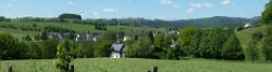
Winterberg ist eine Kleinstadt im Rothaargebirge im deutschen Bundesland Nordrhein-Westfalen und gehört zum Hochsauerlandkreis.
International bekannt ist Winterberg als Austragungsort von Weltcuprennen des Bob- und Rennrodelsports sowie als Wintersportort.
Zu den Sehenswürdigkeiten von Winterberg gehören neben der St.-Jakobus-Kirche ![]() zahlreiche alte Fachwerkhäuser in der Altstadt, die seit Fertigstellung des Waltenbergtunnels vom Durchgangsverkehr freigehalten wird. Auch die St.-Georg-Schanze
zahlreiche alte Fachwerkhäuser in der Altstadt, die seit Fertigstellung des Waltenbergtunnels vom Durchgangsverkehr freigehalten wird. Auch die St.-Georg-Schanze ![]() lockt zahlreiche Besucher an. Ein Musterbeispiel für gelungene Kirchenarchitektur ist die Evangelische Kirche von Winterberg.
lockt zahlreiche Besucher an. Ein Musterbeispiel für gelungene Kirchenarchitektur ist die Evangelische Kirche von Winterberg.
Ein Feuer zerstörte am 6. Juni 2009 das auf der Winterberger Kappe gelegene historische Bobhaus teilweise. Das 1910 durch den Architekten Fritz August Breuhaus geplante, denkmalgeschützte Gebäude soll wieder aufgebaut werden.
Informationen zu Urheber-Rechten | |
|---|---|
Rechte-Ausprägung / Lizenz | by-sa: CREATIVE COMMONS Namensnennung, Weitergabe unter gleichen Bedingungen |
Link zur Rechtebeschreibung | |
Text(e) übernommen von: |
Seite „Winterberg“. In: Wikipedia, Die freie Enzyklopädie. Bearbeitungsstand: 10. April 2012, 16:34 UTC. URL: http://de.wikipedia.org/w/index.php?title=Winterberg&oldid=101897318 |
übernommen / bearbeitet am | 16.04.2012 - 28.06.2022
|
übernommen / bearbeitet durch |
|
0 km
0,4 km
660 m
Öffnungszeiten
Montag - Freitag | 10:00 - 17:00 Uhr | |
Samstag | 10:00 - 14:00 Uhr | |
Sonntag | 10:00 - 13:00 Uhr |
0 km
0,5 km
676 m
0 km
0,4 km
663 m
0 km
0,6 km
672 m
![]()