
Radtour Wipper-Wupper-Ruhr-Emscher-Lippe
Durch das Ruhrgebiet: Hattingen - Gelsenkirchen-Hassel
![]()
Bitte warten - Kartendaten werden geladen
Erstellt am 02.12.2015
zuletzt geändert von InduKult am 07.12.2015
Strecken-Merkmale
gefahren
Gesamtlänge in km
59
Gesamthöhenmeter Aufstieg
240
Durchschn. Steigung Aufstieg %
0,41
Gesamthöhenmeter Abstieg
267
min. Höhe
39
max. Höhe
142
Informationen zu Rechten an den GPS-Track-Daten | |
|---|---|
Rechte-Inhaber | |
Rechte-Ausprägung / Lizenz | by-sa: CREATIVE COMMONS Namensnennung, Weitergabe unter gleichen Bedingungen |
Link zur Rechtebeschreibung | |
gpx-Datei hochgeladen | durch InduKult am 07.12.2015
|
Gesamtzahl Trackpoints
674
Trackpoint-Dichte per km
11
Endorte
Start
Hattingen, Nordrhein-Westfalen, DE (84 m NHN)
Ziel
Gelsenkirchen, Nordrhein-Westfalen, DE (57 m NHN)
gefahren am
04.04.2015
Beschaffenheit
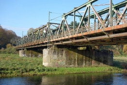
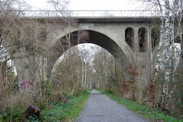
Die Etappe benutzt mehrere der neuen Bahntrassenradwege im Ruhrgebiet:
- Springorum-Radweg Bochum-Dahlhausen - Bochum-Altenbochum (ca. 10 km)
- Erzbahntrasse Bochum-Jahrhunderthalle bis Grimgerhgafen an der Stadgrenze Gelsenkirchen/Herne (ca. 12 km)
- Ewaldbahn in Herten (ca. 2 km)
- Hoheward - Herten-Bertlich (ca. 10 km)
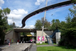
Etappenziel ist der S-Bf. Gelsenkirchen-Hassel (S9 nach Bottrop-Essen-Wuppertal bzw. Marl-Haltern)
Informations-Quellen
Regionalverband Ruhr
Reisebericht
Informationen zu Urheber-Rechten | |
|---|---|
Rechte-Inhaber | |
Rechte-Ausprägung / Lizenz | by-sa: CREATIVE COMMONS Namensnennung, Weitergabe unter gleichen Bedingungen |
Link zur Rechtebeschreibung | |
Bild hochgeladen | durch InduKult am 07.12.2015
|
Weitere Fotos zum virtuellen Vor- und Nachfliegen der Etappe:
https://onedrive.live.com/redir?resid=47B5557E7BEECD46!2889&authkey=!AEsFTiSRxWpZfVQ&ithint=file%2ckmz
Informationen zu Urheber-Rechten | |
|---|---|
Rechte-Ausprägung / Lizenz | by-sa: CREATIVE COMMONS Namensnennung, Weitergabe unter gleichen Bedingungen |
Link zur Rechtebeschreibung | |
übernommen / bearbeitet am | 07.12.2015
|
übernommen / bearbeitet durch |
|
Informationen zu Urheber-Rechten | |
|---|---|
Rechte-Inhaber | |
Rechte-Ausprägung / Lizenz | by-sa: CREATIVE COMMONS Namensnennung, Weitergabe unter gleichen Bedingungen |
Link zur Rechtebeschreibung | |
Bild hochgeladen | durch InduKult am 07.12.2015
|
Informationen zu Urheber-Rechten | |
|---|---|
Rechte-Inhaber | |
Rechte-Ausprägung / Lizenz | by-sa: CREATIVE COMMONS Namensnennung, Weitergabe unter gleichen Bedingungen |
Link zur Rechtebeschreibung | |
Bild hochgeladen | durch InduKult am 07.12.2015
|
Informationen zu Urheber-Rechten | |
|---|---|
Rechte-Inhaber | |
Rechte-Ausprägung / Lizenz | by-sa: CREATIVE COMMONS Namensnennung, Weitergabe unter gleichen Bedingungen |
Link zur Rechtebeschreibung | |
Bild hochgeladen | durch InduKult am 07.12.2015
|