Radtour Lolland und Femö
Dag/day 4: Femø-Rudkøbing
![]()
Bitte warten - Kartendaten werden geladen
Erstellt am 29.04.2023
zuletzt geändert von Ottocolor am 23.07.2023
Strecken-Merkmale
gefahren
Gesamtlänge in km
42
Gesamthöhenmeter Aufstieg
202
Durchschn. Steigung Aufstieg %
0,48
Gesamthöhenmeter Abstieg
202
Informationen zu Rechten an den GPS-Track-Daten | |
|---|---|
Rechte-Inhaber | |
Rechte-Ausprägung / Lizenz | cc0: Public Domain keine Rechte vorbehalten |
Link zur Rechtebeschreibung | |
gpx-Datei hochgeladen | durch Ottocolor am 30.04.2023
|
Gesamtzahl Trackpoints
333
Trackpoint-Dichte per km
8
Endorte
Start
Femø, 85, DK (7 m NHN)
Ziel
Rudkøbing, 83, DK (7 m NHN)
gefahren am
23.04.2023
Wetter
A total weather change. In the morning light rain, later overcast and in the afternoon again sunny. The wind had also changed and blew now light to moderate from the west, so once again a headwind.
Steigungs-Verteilung
Reisebericht
Informationen zu Urheber-Rechten | |
|---|---|
Rechte-Inhaber | |
Rechte-Ausprägung / Lizenz | by-sa: CREATIVE COMMONS Namensnennung, Weitergabe unter gleichen Bedingungen |
Link zur Rechtebeschreibung | |
Bild hochgeladen | durch Ottocolor am 23.07.2023
|
Informationen zu Urheber-Rechten | |
|---|---|
Rechte-Inhaber | |
Rechte-Ausprägung / Lizenz | by-sa: CREATIVE COMMONS Namensnennung, Weitergabe unter gleichen Bedingungen |
Link zur Rechtebeschreibung | |
Bild hochgeladen | durch Ottocolor am 23.07.2023
|
Informationen zu Urheber-Rechten | |
|---|---|
Rechte-Inhaber | |
Rechte-Ausprägung / Lizenz | by-sa: CREATIVE COMMONS Namensnennung, Weitergabe unter gleichen Bedingungen |
Link zur Rechtebeschreibung | |
Bild hochgeladen | durch Ottocolor am 23.07.2023
|
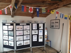
In the rainy weather I didn't fancy any big sightseeing effort in the morning. Instead I lunged about at the harbour, where a lot of information was to be found in a hut called the Egg Shell. Back on Lolland I cycled towards Taars ferry harbour in light to moderate headwind. Yes, now the wind had turned around to a westerly breeze. Nevertheless, I managed to have my packed lunch at the fitness park of Sandby, before the ferry crossing to Langeland. The trip across this island constituted the epilogue of my bicycle holiday. The remainder of my way home again was done by bus and train.
Informationen zu Urheber-Rechten | |
|---|---|
Rechte-Ausprägung / Lizenz | by-sa: CREATIVE COMMONS Namensnennung, Weitergabe unter gleichen Bedingungen |
Link zur Rechtebeschreibung | |
übernommen / bearbeitet am | 23.07.2023
|
übernommen / bearbeitet durch |
|
Informationen zu Urheber-Rechten | |
|---|---|
Rechte-Inhaber | |
Rechte-Ausprägung / Lizenz | by-sa: CREATIVE COMMONS Namensnennung, Weitergabe unter gleichen Bedingungen |
Link zur Rechtebeschreibung | |
Bild hochgeladen | durch Ottocolor am 23.07.2023
|


