
Radtour Eiserner Vorhang Tour, Teil 3 Gdingen-Asch
Dag/day 17: Rassau-Arendsee
![]()
Bitte warten - Kartendaten werden geladen
Erstellt am 14.06.2023
zuletzt geändert von Ottocolor am 28.07.2023
Strecken-Merkmale
gefahren
Gesamtlänge in km
83
Gesamthöhenmeter Aufstieg
164
Durchschn. Steigung Aufstieg %
0,20
Gesamthöhenmeter Abstieg
143
min. Höhe
5
max. Höhe
34
Informationen zu Rechten an den GPS-Track-Daten | |
|---|---|
Rechte-Inhaber | |
Rechte-Ausprägung / Lizenz | cc0: Public Domain keine Rechte vorbehalten |
Link zur Rechtebeschreibung | |
gpx-Datei hochgeladen | durch Ottocolor am 14.06.2023
|
Gesamtzahl Trackpoints
1.013
Trackpoint-Dichte per km
12
Endorte
Start
Amt Neuhaus, NI, DE (9 m NHN)
Ziel
Arendsee (Altmark), ST, DE (30 m NHN)
gefahren am
25.05.2023
Wetter
Scattered clouds with some sunny spells. Warm temperatures above 20°C. Insignificant winds.
Steigungs-Verteilung
Reisebericht
Informationen zu Urheber-Rechten | |
|---|---|
Rechte-Inhaber | |
Rechte-Ausprägung / Lizenz | by-sa: CREATIVE COMMONS Namensnennung, Weitergabe unter gleichen Bedingungen |
Link zur Rechtebeschreibung | |
Bild hochgeladen | durch Ottocolor am 28.07.2023
|
Informationen zu Urheber-Rechten | |
|---|---|
Rechte-Inhaber | |
Rechte-Ausprägung / Lizenz | by-sa: CREATIVE COMMONS Namensnennung, Weitergabe unter gleichen Bedingungen |
Link zur Rechtebeschreibung | |
Bild hochgeladen | durch Ottocolor am 28.07.2023
|
Informationen zu Urheber-Rechten | |
|---|---|
Rechte-Inhaber | |
Rechte-Ausprägung / Lizenz | by-sa: CREATIVE COMMONS Namensnennung, Weitergabe unter gleichen Bedingungen |
Link zur Rechtebeschreibung | |
Bild hochgeladen | durch Ottocolor am 28.07.2023
|
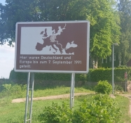
The county here belonged to Lower Saxony and should thus have been a part of West Germany, but had nevertheless belonged to GDR. There had been quite a few territorial shifts after the border was drawn for practical reasons. Most often they were allowed to withstand after reunification, but here the county had returned to the West. Which many in the rest of Lower Saxony were upset about, because the county Neuhaus was deeply in debt. On the whole there were a lot of reservations towards the new compatriots from the East throughout the old West. People talked about "The wall inside the head". In some heads it still exists.
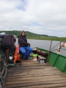
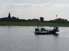
I left Amt Neuhaus on a small spare ferry across the Elbe to Hitzacker. Good service, because there is only one bridge on across the Elbe on the entire 100 km long stretch of the old border. Hitzacker is a gem, but I didn't pay much attention to it since I had seen it before. So I cycled on along and on the dike. A clucking pair of storks in a nest high up on a mast piqued my interest. What a show they gave up there. Had they just become parents? They must have mated long ago. It could not be clarified from below.
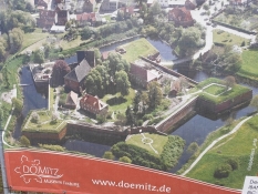
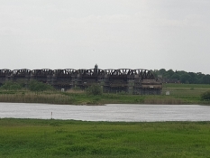
When I reached the modern car bridge at Dömitz, I cycled back to the East. It had only been built after reunification, as the old one had been blown up during the war and not rebuilt in the GDR era. The same with the railway bridge not far away, which, however, is still a ruin that only leads halfway across the Elbe. Cars are clearly more important than trains now. Soon I was in Doemitz, where I visited the fortress. First I made sandwiches on a bench. The fortress was fairly well maintained. You sensed that the works required a great deal of money, which the city did not have, because as a guest you were often asked for contributions. A bit inappropriate, I think. It is the public's task to preserve cultural heritage, not the tourists'. And the public can do it, if the task is prioritized high enough. It was an interesting visit regardless.
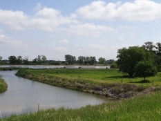
Afterwards I continued cycling along the Elbe. There had been quite a few escape attempts through the river, but some had ended badly, because the current and the width of the river were often underestimated. And the refugees overestimated their power. Plus, from the 80s, there was a n electric so-called signal fence on the dyke, which had a transverse wide lintel. In effect it was very effective in preventing escapes.
In the middle of the afternoon, as usual, I craved for coffee and was about to get out the gas cooker, but luckily I saw beforehand on my mobile phone that the ferry across the Elbe at Luetkenwisch/Schnackenburg had the last departure at 17, so there was no time for coffee now. The previous ferry had been out of service, so I had to speed up to make this one. So my coffee break followed only after the ferry crossing in Schnackenburg itself on the border museum's terrace. This time I got it right.
After resupplying water, I left the Elbe and cycled due south towards Arendsee. It was a beautiful evening, quiet and warm. At the memorial for the looped village of Stresow, I made a short stop. In many places the GDR regime had simply driven out the inhabitants and demolished their houses and farms if they were small and too close to the border. Or if they were suspicious of the residents. Often, family connections to West Germany were enough for people to be forcibly relocated into the country. Already in 1952 the first wave of deportations took place. In the best, or rather worst, Stalinist way.
The stretch to Arendsee became a bit long for me, but I was kindly received at the large campsite and, on top of that, got help with pitching my tent from an extremely friendly camping neighbour, when my rear tent pole had once again collapsed. The restaurant only served wet items, but that was enough as there was enough supply in my left front bag. And the barman gave me a big bag of ice cubes to cool my cold cuts, butter, lard and milk.
Informationen zu Urheber-Rechten | |
|---|---|
Rechte-Ausprägung / Lizenz | by-sa: CREATIVE COMMONS Namensnennung, Weitergabe unter gleichen Bedingungen |
Link zur Rechtebeschreibung | |
übernommen / bearbeitet am | 28.07.2023
|
übernommen / bearbeitet durch |
|
Informationen zu Urheber-Rechten | |
|---|---|
Rechte-Inhaber | |
Rechte-Ausprägung / Lizenz | by-sa: CREATIVE COMMONS Namensnennung, Weitergabe unter gleichen Bedingungen |
Link zur Rechtebeschreibung | |
Bild hochgeladen | durch am 28.07.2023
|
Informationen zu Urheber-Rechten | |
|---|---|
Rechte-Inhaber | |
Rechte-Ausprägung / Lizenz | by-sa: CREATIVE COMMONS Namensnennung, Weitergabe unter gleichen Bedingungen |
Link zur Rechtebeschreibung | |
Bild hochgeladen | durch am 28.07.2023
|
Informationen zu Urheber-Rechten | |
|---|---|
Rechte-Inhaber | |
Rechte-Ausprägung / Lizenz | by-sa: CREATIVE COMMONS Namensnennung, Weitergabe unter gleichen Bedingungen |
Link zur Rechtebeschreibung | |
Bild hochgeladen | durch am 28.07.2023
|
Informationen zu Urheber-Rechten | |
|---|---|
Rechte-Inhaber | |
Rechte-Ausprägung / Lizenz | by-sa: CREATIVE COMMONS Namensnennung, Weitergabe unter gleichen Bedingungen |
Link zur Rechtebeschreibung | |
Bild hochgeladen | durch am 28.07.2023
|
Informationen zu Urheber-Rechten | |
|---|---|
Rechte-Inhaber | |
Rechte-Ausprägung / Lizenz | by-sa: CREATIVE COMMONS Namensnennung, Weitergabe unter gleichen Bedingungen |
Link zur Rechtebeschreibung | |
Bild hochgeladen | durch am 28.07.2023
|
Informationen zu Urheber-Rechten | |
|---|---|
Rechte-Inhaber | |
Rechte-Ausprägung / Lizenz | by-sa: CREATIVE COMMONS Namensnennung, Weitergabe unter gleichen Bedingungen |
Link zur Rechtebeschreibung | |
Bild hochgeladen | durch am 28.07.2023
|