
Radtour Eiserner Vorhang Tour, Teil 3 Gdingen-Asch
Dag/day 19: Knesebeck-Mariental/Horst
![]()
Bitte warten - Kartendaten werden geladen
Erstellt am 14.06.2023
zuletzt geändert von Ottocolor am 29.07.2023
Strecken-Merkmale
gefahren
Gesamtlänge in km
87
Gesamthöhenmeter Aufstieg
372
Durchschn. Steigung Aufstieg %
0,43
Gesamthöhenmeter Abstieg
291
min. Höhe
66
max. Höhe
162
Informationen zu Rechten an den GPS-Track-Daten | |
|---|---|
Rechte-Inhaber | |
Rechte-Ausprägung / Lizenz | cc0: Public Domain keine Rechte vorbehalten |
Link zur Rechtebeschreibung | |
gpx-Datei hochgeladen | durch Ottocolor am 14.06.2023
|
Gesamtzahl Trackpoints
841
Trackpoint-Dichte per km
10
Endorte
Start
Wittingen, NI, DE (69 m NHN)
Ziel
Mariental, NI, DE (150 m NHN)
gefahren am
27.05.2023
Wetter
Warm and sunny weather. Upt to 25°C. Insignificant winds.
Steigungs-Verteilung
Reisebericht
Informationen zu Urheber-Rechten | |
|---|---|
Rechte-Inhaber | |
Rechte-Ausprägung / Lizenz | by-sa: CREATIVE COMMONS Namensnennung, Weitergabe unter gleichen Bedingungen |
Link zur Rechtebeschreibung | |
Bild hochgeladen | durch Ottocolor am 29.07.2023
|
Informationen zu Urheber-Rechten | |
|---|---|
Rechte-Inhaber | |
Rechte-Ausprägung / Lizenz | by-sa: CREATIVE COMMONS Namensnennung, Weitergabe unter gleichen Bedingungen |
Link zur Rechtebeschreibung | |
Bild hochgeladen | durch Ottocolor am 29.07.2023
|
Informationen zu Urheber-Rechten | |
|---|---|
Rechte-Inhaber | |
Rechte-Ausprägung / Lizenz | by-sa: CREATIVE COMMONS Namensnennung, Weitergabe unter gleichen Bedingungen |
Link zur Rechtebeschreibung | |
Bild hochgeladen | durch Ottocolor am 29.07.2023
|
Informationen zu Urheber-Rechten | |
|---|---|
Rechte-Inhaber | |
Rechte-Ausprägung / Lizenz | by-sa: CREATIVE COMMONS Namensnennung, Weitergabe unter gleichen Bedingungen |
Link zur Rechtebeschreibung | |
Bild hochgeladen | durch Ottocolor am 29.07.2023
|
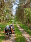
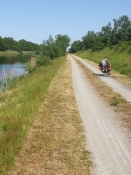
In the morning in Knesebeck I had some trouble with my sleeping mat, which swelled up to a balloon in the sun. That was bad, but I packed it up and took the train back to Wittingen and cycled out to the border at Waddekath. Here I had first had an idea to camp in nature by the old border stream itself, but the place was completely overgrown, so it had been a good idea with the train solution to Knesebeck. I cycled here on the so-called patrol road, the GDR border troops' road of two rows of perforated concrete slabs along the border. But I found that it was a really bad fit for my heavy bike. The overgrown potholes made the ride very bumpy, besides, it was hard to keep the front wheel on the slabs. So I was happy when it ended and a nice stage along small roads mostly on the east side in the Altmark landscape began.
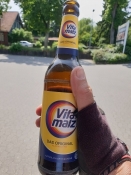
After the town of Brome where I had a bottle of my beloved malt beer, followed the two villages of Boeckwitz (east) and Zicherie (west), which had completely grown together before the border separated them. There was only one inn in the middle of the village, where the inn parlour was in the west, while the toilet was in the east. So of course it was closed, at the latest in 1952. I was now in the Droemling bog landscape, which is a huge depression filled with canals and wet meadows. For a short distance I followed the busy Mittellandkanal, which, as the name suggests, is a canal across the middle of Germany. Of course the canal boats on it had to cross the border, but here they had arranged an efficient passage. After all, both countries were interested in relatively smooth freight transport.
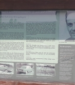
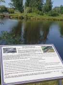
Soon I was in Oebisfelde with its large railway station. Here I myself had crossed the border in the so-called interzone trains on the way from my godparents in the west to my aunt in the east. Now it wasn't far to Mariental/Horst, where I pitched the tent at the campsite. Before that, I sent a video home to my following group on Messenger from the border memorial between Weferlingen in the east and Grasleben in the west. At all previously closed roads there are large signs with the information that here Germany and Europe were divided until the precise date and time of the border opening in 1989 or '90. And there were pictures of the happy people who embraced each other without knowing each other beforehand. I regret I never took a trip down here during that time. It was, after all, world history in pocket format.
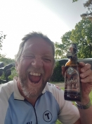
In Grasleben I bought quite a lot and had to face a tough climb afterwards. That made the beer at the campsite taste even better. And I actually slept quite well on my balloon sleeping mat. But the next morning I discarded it. It was Whitsunday, so I couldn't buy a new one until Tuesday, and consequently had to sleep in a hotel until then. Well, too bad ;-)
Informationen zu Urheber-Rechten | |
|---|---|
Rechte-Ausprägung / Lizenz | by-sa: CREATIVE COMMONS Namensnennung, Weitergabe unter gleichen Bedingungen |
Link zur Rechtebeschreibung | |
übernommen / bearbeitet am | 29.07.2023
|
übernommen / bearbeitet durch |
|
Informationen zu Urheber-Rechten | |
|---|---|
Rechte-Inhaber | |
Rechte-Ausprägung / Lizenz | by-sa: CREATIVE COMMONS Namensnennung, Weitergabe unter gleichen Bedingungen |
Link zur Rechtebeschreibung | |
Bild hochgeladen | durch Ottocolor am 29.07.2023
|
Informationen zu Urheber-Rechten | |
|---|---|
Rechte-Inhaber | |
Rechte-Ausprägung / Lizenz | by-sa: CREATIVE COMMONS Namensnennung, Weitergabe unter gleichen Bedingungen |
Link zur Rechtebeschreibung | |
Bild hochgeladen | durch Ottocolor am 29.07.2023
|
Informationen zu Urheber-Rechten | |
|---|---|
Rechte-Inhaber | |
Rechte-Ausprägung / Lizenz | by-sa: CREATIVE COMMONS Namensnennung, Weitergabe unter gleichen Bedingungen |
Link zur Rechtebeschreibung | |
Bild hochgeladen | durch Ottocolor am 29.07.2023
|