
Radtour Eiserner Vorhang Tour, Teil 3 Gdingen-Asch
Dag/day 28: Tann/Dippach-Irmelshausen
![]()
Bitte warten - Kartendaten werden geladen
Erstellt am 14.06.2023
zuletzt geändert von Ottocolor am 02.08.2023
Strecken-Merkmale
gefahren
Gesamtlänge in km
71
Gesamthöhenmeter Aufstieg
1.029
Durchschn. Steigung Aufstieg %
1,45
Gesamthöhenmeter Abstieg
1.181
min. Höhe
282
max. Höhe
797
Informationen zu Rechten an den GPS-Track-Daten | |
|---|---|
Rechte-Inhaber | |
Rechte-Ausprägung / Lizenz | cc0: Public Domain keine Rechte vorbehalten |
Link zur Rechtebeschreibung | |
gpx-Datei hochgeladen | durch Ottocolor am 15.06.2023
|
Gesamtzahl Trackpoints
1.160
Trackpoint-Dichte per km
16
Endorte
Start
Tann (Rhön), HE, DE (434 m NHN)
Ziel
Höchheim, BY, DE (282 m NHN)
gefahren am
05.06.2023
Wetter
Warm and sunny during daytime and a ligth northeaserly breeze. In the evening a short rain shower.
Steigungs-Verteilung
Reisebericht
Informationen zu Urheber-Rechten | |
|---|---|
Rechte-Inhaber | |
Rechte-Ausprägung / Lizenz | by-sa: CREATIVE COMMONS Namensnennung, Weitergabe unter gleichen Bedingungen |
Link zur Rechtebeschreibung | |
Bild hochgeladen | durch Ottocolor am 02.08.2023
|
Informationen zu Urheber-Rechten | |
|---|---|
Rechte-Inhaber | |
Rechte-Ausprägung / Lizenz | by-sa: CREATIVE COMMONS Namensnennung, Weitergabe unter gleichen Bedingungen |
Link zur Rechtebeschreibung | |
Bild hochgeladen | durch Ottocolor am 02.08.2023
|
Informationen zu Urheber-Rechten | |
|---|---|
Rechte-Inhaber | |
Rechte-Ausprägung / Lizenz | by-sa: CREATIVE COMMONS Namensnennung, Weitergabe unter gleichen Bedingungen |
Link zur Rechtebeschreibung | |
Bild hochgeladen | durch Ottocolor am 02.08.2023
|
Informationen zu Urheber-Rechten | |
|---|---|
Rechte-Inhaber | |
Rechte-Ausprägung / Lizenz | by-sa: CREATIVE COMMONS Namensnennung, Weitergabe unter gleichen Bedingungen |
Link zur Rechtebeschreibung | |
Bild hochgeladen | durch Ottocolor am 02.08.2023
|
In the morning I lay down in the stream as if it were a bathtub and let the clear water gurgle over me. And there were fresh rolls for breakfast. But as soon as my front wheel hit the tarmac, easy life was over.
During the next two hours I only made approx. ten kilometers. It just ascended steeply. I had to go all the way up to 817 m, and this was the highest point of the whole trip shortly before Frankenheim/Rhoen. The trail wasn't good either, but still acceptable. I wheeled the bike for a long time. And the forest was beautiful and peaceful. At an idyllic forest lake, I met a group of cyclists in the opposite direction. Their goal was the Baltic Sea at Travemuende. We struck up a good chat, which of course did not add to my pace, but certainly to my mood. And that was also important in this terrain.
Between Frankenheim and Fladungen there was a wild descent, but also a hopeless little path where I had to wheel once again. In Fladungen, I had entered Bavaria, and I was a little proud of that, because it is the southernmost state. I was missing a full 47 km of today's stage, but still shopped quite a lot, including a few beers, as there would be no more shops before my finish at Irmelshausen. Of course there were more climbs to come, but I felt in good shape. And I found wells with drinking water in almost every village, so I could get enough water. Also to make coffee of in Stedtlingen on a small playground, where some mothers were playing with their toddlers. Still 29 km to go. And more hills to come.
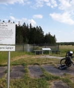
Shortly before the finish line, another border memorial came, where the sheer depth of the fortification facilities in particular made an impression on me. The GDR had given up a lot of land. And then I read that in 2001 a tourist had found an intact mine in the ground, which had not been found before. Shocking. After all, I had waded around a lot in those border areas. From the West German side, there were only signs and barriers where the roads ended. Then followed the border itself, marked with concrete pillars bearing the GDR's state coat of arms. Then followed an open section and only then the first fence. There was no no man's land, so if you overlooked a sign, you could easily enter East German territory. By which you put your life at risk.
Now I was close to my goal, a large campsite by a bathing lake outside the village of Irmelshausen in Bavaria. Camping life was really going on here with barbecues, music and all kinds of outdoor games plus swimming in the lake. And then a very unexpected shower came down just as I arrived. Nowhere else can this cause so much unrest. I tried to find the campsite landlord but gave up and popped a beer instead. And then he came up and offered me to sleep in one changing cabin and park the bike in the other. Then I didn't have to pitch my tent, and as it rained ... Nicely done of him. I placed the bike in the women's compartment, because my bike is a girl, and moved into the men's one. A bath in the lake was good. The rain had chased away all the bathers. But it was not a violent shower. Really just nice cooling water from above. And I could cook food under a covered table-bench set. Soon after the rain stopped and camping life flared up again around me. No one noticed me, but it didn't matter. If only I could be allowed to be in peace. And a lovely calm fell over me and satisfaction with the place, the trip and life itself.
Informationen zu Urheber-Rechten | |
|---|---|
Rechte-Ausprägung / Lizenz | by-sa: CREATIVE COMMONS Namensnennung, Weitergabe unter gleichen Bedingungen |
Link zur Rechtebeschreibung | |
übernommen / bearbeitet am | 02.08.2023
|
übernommen / bearbeitet durch |
|