
Cycle Tour Bike holiday along the Meuse
Dag/day 8: Namur
![]()
Please wait - map data are loading
Added on 15 Jul 2021
last edited by Ottocolor on 20 Dec 2022
Cycle route metrics
ridden
Total distance in km
11
Cumulative elevation gain in m
229
Avg. slope uphill in %
2,08
Cumulative elevation loss in m
201
Min. height
84
Max. height
219
Information about rights to the gps-track data | |
|---|---|
Rights owner | |
Rights characteristic / license | cc0: Public Domain no Rights reserved |
Link to the description of the license | |
GPX file uploaded | by Ottocolor on 15 Jul 2021
|
Track points in total
420
Track points per km (avg)
38
Start/endpoint
Start location
Namur, Wallonia, BE (87 m NHN)
End location
Namur, Wallonia, BE (116 m NHN)
ridden on
11 Jul 2021
Weather
In the morning overcast and a few drops of rain. Later it brightened up with a lot of sun. Warm temperatures of about 23 to 24°C.
Properties
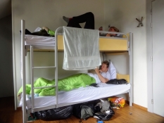
A day on foot in the streets of Namur, except a short cycle trip into the centre along the river and back to the youth hostel.
Slope Gradient Distribution
Remarks
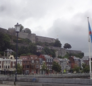
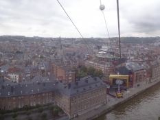
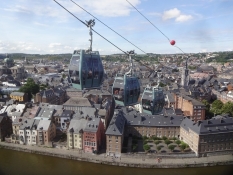
Besides the foot march of about seven kilometres we also went by cablecar to the fortress and back down again.
Travel report
Information about copyright | |
|---|---|
Rights owner | |
Rights characteristic / license | by-sa: CREATIVE COMMONS Attribution-ShareAlike |
Link to the description of the license | |
Image has been uploaded | by Ottocolor on 22 Jul 2021
|
Information about copyright | |
|---|---|
Rights owner | |
Rights characteristic / license | by-sa: CREATIVE COMMONS Attribution-ShareAlike |
Link to the description of the license | |
Image has been uploaded | by Ottocolor on 22 Jul 2021
|
Information about copyright | |
|---|---|
Rights owner | |
Rights characteristic / license | by-sa: CREATIVE COMMONS Attribution-ShareAlike |
Link to the description of the license | |
Image has been uploaded | by Ottocolor on 22 Jul 2021
|
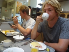
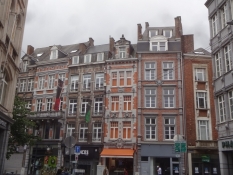
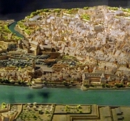
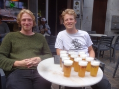
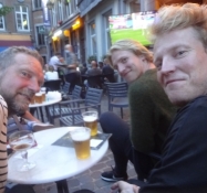
The restday in Namur turned out as one of the best days of the cycling holiday. It's nice to ride one's bike, but relaxing in a lovely city like Namur is also great. It's the capital of Wallonia, and we had a look at the parliament building on the riverbank from the outside. Afterwards we parked our bikes in the city centre and went for a lazy stroll in the old town before taking the aerial cableway up to the mighty fortress, which soars on a rock, squeezed in between two rivers, the mouth of the Sambre and the Meuse. It's dispersed into many buildings and includes a vast underground area with milelong corridors, we visitied on a guided tour later in the day. Before that we enjoyed a lunch of grilled sausages with a nice view of the Meuse valley southwards. The weather had turned nice again with a lot of sunshine and warm temperatures. Our first sight was the museum, which tells the history of Namur. Quite a comprehensive matter, and one felt the wish of the Walloons to present their capital in the best possible light. The exhibition began, oddly enough, with the creation of mother Earth 4.5 billion years ago, when a huge cloud of gasses were condensed into - Namur surrounded by the remainder of the earth! Then we submerged into it and learned about the logistics of a medieval fortress before emerging from the depth into the sunshine and sailing down into the city centre again via the cableway. Now we were in for beer, lots of beer, dinner and watching football in a restaurant on the central square, where football fans from many countries were gathered. Englishmen and Italians were the easiest ones to spot, as their countries were to play in the final of the UEFA Euro 2020 tonight. It went all the way to a penalty shoot out, where England blew all their chances by muffing three penalties. This made the Italian fans ("tifosis") to go nuts in a very loud celebration of the European triumph, while we retreated to our hostel on our bikes to a well deserved night's sleep.
Information about copyright | |
|---|---|
Rights characteristic / license | by-sa: CREATIVE COMMONS Attribution-ShareAlike |
Link to the description of the license | |
taken over / edited on | 20 Dec 2022
|
taken over / edited by |
|
Information about copyright | |
|---|---|
Rights owner | |
Rights characteristic / license | by-sa: CREATIVE COMMONS Attribution-ShareAlike |
Link to the description of the license | |
Image has been uploaded | by Ottocolor on 22 Jul 2021
|
Information about copyright | |
|---|---|
Rights owner | |
Rights characteristic / license | by-sa: CREATIVE COMMONS Attribution-ShareAlike |
Link to the description of the license | |
Image has been uploaded | by Ottocolor on 22 Jul 2021
|
Information about copyright | |
|---|---|
Rights owner | |
Rights characteristic / license | by-sa: CREATIVE COMMONS Attribution-ShareAlike |
Link to the description of the license | |
Image has been uploaded | by Ottocolor on 22 Jul 2021
|
Information about copyright | |
|---|---|
Rights owner | |
Rights characteristic / license | by-sa: CREATIVE COMMONS Attribution-ShareAlike |
Link to the description of the license | |
Image has been uploaded | by Ottocolor on 22 Jul 2021
|
Information about copyright | |
|---|---|
Rights owner | |
Rights characteristic / license | by-sa: CREATIVE COMMONS Attribution-ShareAlike |
Link to the description of the license | |
Image has been uploaded | by Ottocolor on 22 Jul 2021
|
Information about copyright | |
|---|---|
Rights owner | |
Rights characteristic / license | by-sa: CREATIVE COMMONS Attribution-ShareAlike |
Link to the description of the license | |
Image has been uploaded | by Ottocolor on 22 Jul 2021
|