
Cycle Tour Grand Canyon du Verdon (Südseite)
Travel report: Südseite der Verdon-Schlucht
Actions
![]()
Please wait - map data are loading
Added on 06 Oct 2017,
last edited by Tandemteam-Traudel_und_Dieter on 09 Oct 2017
Actions
Cycle route metrics
planned
ridden
Total distance in km
108
99
Cumulative elevation gain in m
2.105
1.794
Avg. slope uphill in %
1,95
1,81
Cumulative elevation loss in m
2.269
1.831
Total cycling hours
-
7,0
Avg. pace in km/h
-
14,1
Information about rights to the gps-track data | |
|---|---|
Rights owner | |
Rights characteristic / license | by-sa: CREATIVE COMMONS Attribution-ShareAlike |
Link to the description of the license | |
GPX file uploaded | by Tandemteam-Traudel_und_Dieter on 06 Oct 2017
|
Track points in total
1.869
2.144
Track points per km (avg)
17
22
Start/endpoint
Start location
Aups, Provence-Alpes-Côte d'Azur, FR (708 m NHN)
End location
Aups, Provence-Alpes-Côte d'Azur, FR (544 m NHN)
Character
Information about copyright | |
|---|---|
Rights characteristic / license | by-sa: CREATIVE COMMONS Attribution-ShareAlike |
Link to the description of the license | |
taken over / edited on | 06 Oct 2017 - 09 Oct 2017
|
taken over / edited by |
|
Landscape
Information about copyright | |
|---|---|
Rights characteristic / license | by-sa: CREATIVE COMMONS Attribution-ShareAlike |
Link to the description of the license | |
taken over / edited on | 06 Oct 2017 - 09 Oct 2017
|
taken over / edited by |
|
Travel to and from ...
Mit Auto zum Campingplatz in Aiguines.
In Frankreich ist es nicht erlaubt, ein Tandem im Zug mitzunehmen!
Stages
Information about copyright | |
|---|---|
Rights owner | |
Rights characteristic / license | © all rights reserved. |
Image has been uploaded | by Tandemteam-Traudel_und_Dieter on 07 Oct 2017
|
99 km
Aiguines
Beds4Cyclists, worth visiting and infrastructure
Name and address
Latitude / Longitude
Phone
Fax
Mobile
Type of accommodation
Rating for cyclists
Route km
Dist. to route
Elevation
45 km
0,0 km
772 m
Information about copyright | |
|---|---|
Rights owner | |
Rights characteristic / license | by: CREATIVE COMMONS Attribution |
Link to the description of the license | |
Image taken over from | |
Image has been uploaded | by biroto-Redaktion on 28 Feb 2015
|
Information about copyright | |
|---|---|
Rights owner | |
Rights characteristic / license | by-sa: CREATIVE COMMONS Attribution-ShareAlike |
Link to the description of the license | |
Image taken over from | commons.wikimedia.org/wiki/File:Gorges_du_Verdon_River_from_Bottom_0364.jpg |
Image has been uploaded | by biroto-Redaktion on 28 Feb 2015
|
Information about copyright | |
|---|---|
Rights owner | |
Rights characteristic / license | by-sa: CREATIVE COMMONS Attribution-ShareAlike |
Link to the description of the license | |
Image taken over from | commons.wikimedia.org/wiki/File:Route_des_Crêtes-Gorges_du_Verdon_Ost.jpg |
Image has been uploaded | by biroto-Redaktion on 28 Feb 2015
|
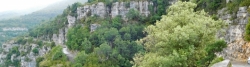
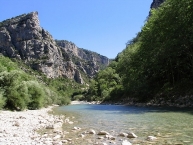
The Verdon Gorge (in French: Gorges du Verdon or Grand canyon du Verdon), in south-eastern France (Alpes-de-Haute-Provence), is a river canyon that is often considered to be one of Europe's most beautiful. It is about 25 kilometres long and up to 700 metres deep. It was formed by the Verdon River ![]() , which is named for its startling turquoise-green colour, one of the location's distinguishing characteristics. The most impressive part lies between the towns of Castellane
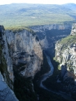
, which is named for its startling turquoise-green colour, one of the location's distinguishing characteristics. The most impressive part lies between the towns of Castellane ![]() and Moustiers-Sainte-Marie
and Moustiers-Sainte-Marie ![]() , where the river has cut a ravine to a depth of 700 metres through the limestone mass. At the end of the canyon, the Verdon River flows into the artificial lake of Sainte-Croix-du-Verdon
, where the river has cut a ravine to a depth of 700 metres through the limestone mass. At the end of the canyon, the Verdon River flows into the artificial lake of Sainte-Croix-du-Verdon ![]() (in French: Lac de Sainte-Croix
(in French: Lac de Sainte-Croix ![]() ).
).
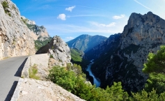
Because of its proximity to the French Riviera, the gorge is very popular with tourists, who can drive around its rim, rent kayaks to travel on the river, or hike. The limestone walls, which are several hundreds of metres high, attract many rock climbers.
Information about copyright | |
|---|---|
Rights characteristic / license | by-sa: CREATIVE COMMONS Attribution-ShareAlike |
Link to the description of the license | |
Input taken over from: |
Wikipedia contributors, 'Verdon Gorge', Wikipedia, The Free Encyclopedia, 24 February 2015, 04:48 UTC, <http://en.wikipedia.org/w/index.php?title=Verdon_Gorge&oldid=648584554> [accessed 28 February 2015] |
taken over / edited on | 28 Feb 2015
|
taken over / edited by |
|
71 km
4,1 km
467 m