
Cycle Route Sunderland - Inverness
No. of cycle route 7
Actions
![]()
Please wait - map data are loading
Added on 30 May 2012,
last edited by biroto-Redaktion on 13 Jan 2021
Actions
Cycle route metrics
Total distance in km
855
Information about rights to the gps-track data | |
|---|---|
Rights owner | OpenStreetMap and Contributors + biroto-Redaktion (biroto.eu) |
Rights characteristic / license | Contains information from OpenStreetMap, which is made available here under the Open Database License(ODbL) |
Link to the description of the license | |
GPX file taken from | |
GPX file uploaded | by biroto-Redaktion on 13 Jan 2021
|
Track points in total
12.922
Track points per km (avg)
15
Start/endpoint
Start location
Sunderland, England, GB (0 m NHN)
End location
Inverness, Scotland, GB (11 m NHN)
Beds4Cyclists, worth visiting and infrastructure
Name and address
Latitude / Longitude
Phone
Fax
Mobile
Type of accommodation
Rating for cyclists
Route km
Dist. to route
Elevation
95 km
2,9 km
278 m
124 km
1,8 km
107 m
Information about copyright | |
|---|---|
Rights owner | |
Rights characteristic / license | by-sa: CREATIVE COMMONS Attribution-ShareAlike |
Link to the description of the license | |
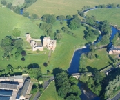
Image taken over from | https://commons.wikimedia.org/wiki/File:RiverEamontAtBroughamCastle(SimonLedingham)Jun2004.jpg |
Image has been uploaded | by biroto-Redaktion on 30 Apr 2017
|
Information about copyright | |
|---|---|
Rights owner | |
Rights characteristic / license | by-sa: CREATIVE COMMONS Attribution-ShareAlike |
Link to the description of the license | |
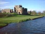
Image taken over from | https://commons.wikimedia.org/wiki/File:Brougham_Castle_-_geograph.org.uk_-_17714.jpg |
Image has been uploaded | by biroto-Redaktion on 30 Apr 2017
|
Information about copyright | |
|---|---|
Rights owner | |
Rights characteristic / license | by-sa: CREATIVE COMMONS Attribution-ShareAlike |
Link to the description of the license | |
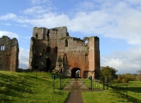
Image taken over from | https://commons.wikimedia.org/wiki/File:Brougham_Castle_near_Penrith_-_geograph.org.uk_-_45557.jpg |
Image has been uploaded | by biroto-Redaktion on 30 Apr 2017
|
Hours of opening
April - Sept.: 10:00 - 18:00
Oct.: 10:00 - 16:00
126 km
3,5 km
142 m
Information about copyright | |
|---|---|
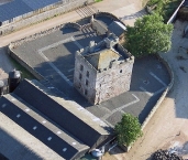
Rights owner | Clifton Hall was a fortified manor house in the Clifton, Cumbria, England. Dating from around 1400, |
Rights characteristic / license | by-sa: CREATIVE COMMONS Attribution-ShareAlike |
Link to the description of the license | |
Image taken over from | https://commons.wikimedia.org/wiki/File:Clifton_Hall_overhead_shot.jpg |
Image has been uploaded | by biroto-Redaktion on 08 May 2017
|
Information about copyright | |
|---|---|
Rights owner | |
Rights characteristic / license | by-sa: CREATIVE COMMONS Attribution-ShareAlike |
Link to the description of the license | |
Image taken over from | |
Image has been uploaded | by biroto-Redaktion on 08 May 2017
|
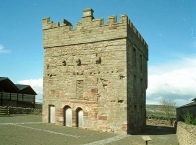
Clifton Hall was a fortified manor house in the Clifton ![]() , Cumbria, England. Dating from around 1400, it was constructed by either Elianor Engaine or her son-in-law William Wybergh, and was held by the Wybergh family until the 19th century. Initially taking the form of an "H"-plan design built around a central hall, around 1500 a three-story stone pele tower was added, providing both additional security and acting as a status symbol for the family. At the start of the 17th century a new stone hall was added to the south of the tower.
, Cumbria, England. Dating from around 1400, it was constructed by either Elianor Engaine or her son-in-law William Wybergh, and was held by the Wybergh family until the 19th century. Initially taking the form of an "H"-plan design built around a central hall, around 1500 a three-story stone pele tower was added, providing both additional security and acting as a status symbol for the family. At the start of the 17th century a new stone hall was added to the south of the tower.
The Wyberghs were able to retain Clifton Hall, despite the challenges of the English Civil War, but the house was caught up in the Jacobite risings of 1715 and 1745. In the early 19th century most of Clifton Hall was pulled down to make way for a new farmhouse, and only the pele tower survived. In the 21st century the tower is in the care of English Heritage and operates as a tourist attraction.
Information about copyright | |
|---|---|
Rights characteristic / license | by-sa: CREATIVE COMMONS Attribution-ShareAlike |
Link to the description of the license | |
Input taken over from: |
Wikipedia contributors, 'Clifton Hall, Cumbria', Wikipedia, The Free Encyclopedia, 24 January 2017, 20:12 UTC, <https://en.wikipedia.org/w/index.php?title=Clifton_Hall,_Cumbria&oldid=761786084> [accessed 8 May 2017] |
taken over / edited on | 08 May 2017
|
taken over / edited by |
|
Hours of opening
Open any reasonable time during daylight hours
126 km
0,2 km
136 m
165 km
0,2 km
24 m
Information about copyright | |
|---|---|
Rights owner | en.wikipedia.org/wiki/User:Diliff |
Rights characteristic / license | by-sa: CREATIVE COMMONS Attribution-ShareAlike |
Link to the description of the license | |
Image taken over from | https://commons.wikimedia.org/wiki/File:Carlisle_Cathedral_Tracery,_Cumbria,_UK_-_Diliff.jpg |
Image has been uploaded | by biroto-Redaktion on 08 May 2017
|
Information about copyright | |
|---|---|
Rights owner | |
Rights characteristic / license | cc0: Public Domain no Rights reserved |
Link to the description of the license | |
Image taken over from | https://commons.wikimedia.org/wiki/File:Carlisle_Cathedral_Interior.jpg |
Image has been uploaded | by biroto-Redaktion on 08 May 2017
|
Information about copyright | |
|---|---|
Rights owner | |
Rights characteristic / license | by: CREATIVE COMMONS Attribution |
Link to the description of the license | |
Image taken over from | https://commons.wikimedia.org/wiki/File:Carlisle_Cathedral_Ceiling_(7167745504).jpg |
Image has been uploaded | by biroto-Redaktion on 08 May 2017
|
Information about copyright | |
|---|---|
Rights owner | |
Rights characteristic / license | by-sa: CREATIVE COMMONS Attribution-ShareAlike |
Link to the description of the license | |
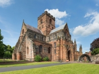
Image taken over from | https://commons.wikimedia.org/wiki/File:Carlisle_Cathedral_Exterior,_Cumbria,_UK_-_Diliff.jpg |
Image has been uploaded | by biroto-Redaktion on 08 May 2017
|
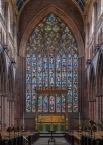
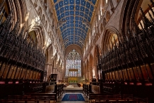
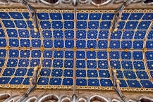
The Cathedral Church of the Holy and Undivided Trinity, otherwise called Carlisle Cathedral, is the seat of the Anglican Bishop of Carlisle. It is located in Carlisle ![]() , in Cumbria, North West England. It was founded as an Augustinian priory and became a cathedral in 1133.
, in Cumbria, North West England. It was founded as an Augustinian priory and became a cathedral in 1133.
Carlisle, because of heavy losses to its fabric, is the second smallest (after Oxford ![]() ), of England's ancient cathedrals. Its notable features include some fine figurative stone carving, a set of medieval choir stalls and the largest window in the Flowing Decorated Gothic style in England.
), of England's ancient cathedrals. Its notable features include some fine figurative stone carving, a set of medieval choir stalls and the largest window in the Flowing Decorated Gothic style in England.
Information about copyright | |
|---|---|
Rights characteristic / license | by-sa: CREATIVE COMMONS Attribution-ShareAlike |
Link to the description of the license | |
Input taken over from: |
Wikipedia contributors, 'Carlisle Cathedral', Wikipedia, The Free Encyclopedia, 20 March 2017, 16:40 UTC, <https://en.wikipedia.org/w/index.php?title=Carlisle_Cathedral&oldid=771276912> [accessed 8 May 2017] |
taken over / edited on | 08 May 2017
|
taken over / edited by |
|
Hours of opening
The Cathedral is usually open daily from 7.30am to 6.15pm Monday to Saturday, and 7.30am to 5.00pm on Sunday.
For service times please see the section on Daily Services or the Cathedral diary.
Please note that the Cathedral is regularly used for a variety of public and private events which may not be highlighted in the website diary.
![]()