
Cycle Route Around the Szczecin Lagoon
No. of cycle route 66
Actions
![]()
Please wait - map data are loading
Added on 26 Aug 2013,
last edited by biroto-Redaktion on 03 Nov 2023
Actions
Cycle route metrics
Total distance in km
298
Information about rights to the gps-track data | |
|---|---|
Rights owner | OpenStreetMap and Contributors + biroto-Redaktion (biroto.eu) |
Rights characteristic / license | Contains information from OpenStreetMap, which is made available here under the Open Database License(ODbL) |
Link to the description of the license | |
GPX file taken from | |
GPX file uploaded | by biroto-Redaktion on 03 Nov 2023
|
Track points in total
4.352
Track points per km (avg)
15
Start/endpoint
Start location
Anklam, MV, DE (6 m NHN)
End location
Anklam, MV, DE (6 m NHN)
Beds4Cyclists, worth visiting and infrastructure
Name and address
Latitude / Longitude
Phone
Fax
Mobile
Type of accommodation
Rating for cyclists
Route km
Dist. to route
Elevation
1 km
0,1 km
10 m
1 km
0,4 km
8 m
1 km
0,0 km
20 m
Information about copyright | |
|---|---|
Rights owner | Lupi82 |
Rights characteristic / license | by-sa: CREATIVE COMMONS Attribution-ShareAlike |
Link to the description of the license | |
Image taken over from | https://commons.wikimedia.org/wiki/File:MarienkircheAnklam.JPG |
Image has been uploaded | by biroto-Redaktion on 13 Aug 2023
|
Information about copyright | |
|---|---|
Rights owner | |
Rights characteristic / license | by-sa: CREATIVE COMMONS Attribution-ShareAlike |
Link to the description of the license | |
Image taken over from | |
Image has been uploaded | by biroto-Redaktion on 13 Aug 2023
|
Information about copyright | |
|---|---|
Rights owner | Peer Wittig |
Rights characteristic / license | by-sa: CREATIVE COMMONS Attribution-ShareAlike |
Link to the description of the license | |
Image taken over from | https://commons.wikimedia.org/wiki/File:2014-10-28_nikolaikirche-anklam.jpg |
Image has been uploaded | by biroto-Redaktion on 13 Aug 2023
|
Information about copyright | |
|---|---|
Rights owner | https://commons.wikimedia.org/w/index.php?title=User:Schafevormfenster |
Rights characteristic / license | by-sa: CREATIVE COMMONS Attribution-ShareAlike |
Link to the description of the license | |
Image taken over from | https://commons.wikimedia.org/wiki/File:Anklamer_Marktplatz_.jpeg |
Image has been uploaded | by biroto-Redaktion on 13 Aug 2023
|
Die Hansestadt Anklam befindet sich in Vorpommern.
Hintergrund
Die Stadt liegt in der Reihe der traditionsreichen Hansestädte entlang der vorpommerschen Ostseeküste Stralsund - Greifswald - Anklam - Stettin. Ihre Entwicklung verdankt die Stadt dem Fluss Peene, der historischen Verbindung zum Stettiner Haff und ihrer exponierten Lage an der Querung des unwegsamen Flusstales. Als Geburtsstadt des Flugpioniers Otto Lilienthal gibt sie sich den Beinamen Lilienthalstadt.
Sehenswürdigkeiten
Kirchen
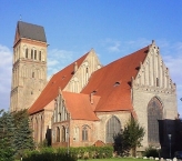
- ⊙Marienkirche

Dreischiffige romanische Hallenkirche mit spätromanischem Chor sowie Sakristei, ursprünglich Doppelturmanlage aus dem 13. Jahrhundert, später gotisch überbaut. Trotz schwerer Kriegsschäden und dem Verlust des Turmhelmes überstand die Marienkirche den Zweiten Weltkrieg besser als die Nikolaikirche. - ⊙Nikolaikirche
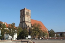
Dreischiffige, siebenjochige gotische Hallenkirche aus dem 13. Jahrhundert. Im Zweiten Weltkrieg fast vollständig zerstört. Seit 1994 wird am Wiederaufbau gearbeitet. Zunächst wurde das Kirchenschiff mit einem Notdach gesichert, 2010/11 wurde das Dach in der ursprünglichen Form und Höhe wiedererrichtet. Seit 2004 wurden zudem neue Bleiglasfenster, teils im traditionellen Stil, teils aber auch nach modernen Entwürfen, eingesetzt. Das Gebäude wird nicht mehr als Kirche, sondern für Ausstellungen und Veranstaltungen genutzt. Der einst über 100 Meter hohe Spitzturm soll nicht im originalen Stil wiederhergestellt, sondern durch im Rahmen des Projekts Ikareum durch eine moderne, unverkleidete und luftige Konstruktion ersetzt werden, die an die historische Kubatur anlehnt. - ⊙Garnisonskirche (Heilig-Geist-Kirche)
An der Stelle stand bereits 1272 eine gotische Backsteinkirche, die jedoch 1376 und 1659 niederbrannte. 1738 wurde die barocke Garnisonskirche errichtet. Sie wurde 1854 zum Wohngebäude umgebaut. Nach der Zerstörung im Zweiten Weltkrieg wurde sie wieder aufgebaut und nach der Wiedervereinigung restauriert.
Bauwerke
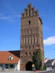
- ⊙Steintor, Schulstraße 1
Aus dem 13. Jahrhundert stammendes höchstes Stadttor Pommerns. Heute Sitz des regionalgeschichtlichen Museums. - ⊙Pulverturm
Teil der mittelalterlichen Befestigungsanlage, im 19. Jh. durch Gustav Spörer zur Sonnenflecken-Beobachtung genutzt. - ⊙Gotisches Giebelhaus, Frauenstraße 12. Ältester Profanbau der Stadt, 1451 erstmals erwähnt, dreigeschossig, Stufengiebel mit fünf Fialen, seltene Dippelbalkendecke.
- ⊙Wesselsche Mühle. Holländerwindmühle aus dem Jahre 1728, seltener Typ eines Dachholländers, bei dem die Holländerwindmühle auf ein Wohnhaus aufgesetzt ist. Auch Schwedenmühle genannt, da sie während der fast 100-jährigen Teilung der Stadt als Rathaus des schwedischen Teils diente.
- Armen- und Arbeitshaus, 1849, Friedrich August Stüler
- ⊙ Ehemaliges Gymnasium, Wollweberstraße 1/2.
1851 durch den Deutschen Kaiser als Muster eines modernen Schulbaus eingeweiht. - ⊙ Ehemalige Kriegsschule, Friedländer Landstraße 3.
1870/71, siebente von insgesamt zehn königlichen Kriegsschulen in Preußen. - ⊙Ehemaliges Städtisches Warmbad, Demminer Straße 5. 1894 als erstes seiner Art in Pommern errichtet.
Museen
- ⊙Museum im Steintor, Schulstr. 1, 17389 Anklam. ☎ +49 3971 245503.
Museum über die Geschichte Anklams und des Peenetals.
Geöffnet: Mai-Sep: Di-Fr: 10:00-17:00, Sa-So: 13:00-17:00; Okt-Apr: Mi-Fr: 11:00-15:30, So: 13:00-15:30. Preis: Eintritt: 4,50 € (ermäßigt: 3,50 €). - ⊙Otto-Lilienthal-Museum, Ellbogenstr. 1, 17389 Anklam. ☎ +49 3971 259987
Museum über den Flugpionier und Erfinder Otto Lilienthal.
Geöffnet: Mai-Okt: Di-Fr: 10:00-17:00, Sa, So: 13:00-17:00; Nov-Apr: Mi-Fr: 11:00-15:30, So: 13:00-15:30. Preis: Eintritt: 4,50 € (ermäßigt: 3,50 €).
Verschiedenes
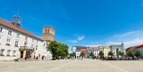
- ⊙Marktplatz mit Greifenbrunnen. Seit 2004 erfährt man auf den so genannten Jahrhundertbändern Schritt für Schritt die Historie der alten Hansestadt.
- ⊙Ehemaliges Wehrmachtsgefängnis Anklam (Friedenszentrum Anklam / Zentrum für Friedensarbeit Otto Lilienthal – Hansestadt Anklam), Adolf-Damaschke-Straße 5a. ☎ +49 3971 2937999,
Lern- und Gedenkort zur NS-Militärjustiz. - ⊙Jüdischer Friedhof, Min Hüsung. Mahn- und Gedenkstätte.
- ⊙Bluthsluster Park, Bluthsluster Straße
Ab 1820 auf Initiative des Kaufmanns Eduarth Bluth angelegter Landschaftsgarten.
Information about copyright | |
|---|---|
Rights characteristic / license | by-sa: CREATIVE COMMONS Attribution-ShareAlike |
Link to the description of the license | |
Input taken over from: |
Wikivoyage-Bearbeiter, 'Anklam', Wikivoyage, 1. Januar 2023, 16:18 UTC, https://de.wikivoyage.org/w/index.php?title=Anklam&oldid=1506330 |
taken over / edited on | 13 Aug 2023
|
taken over / edited by |
|
1 km
1,6 km
13 m
20 km
0,9 km
5 m
Hours of opening
Ab Kamp jede volle Stunde ab 10:00 Uhr bis 17:00 Uhr.
Der Fahrplan ist gültig ab 28.04. bis einschließlich 03.10.2023.
| Fahrpreise | einfache Fahrt | Hin-/Rückfahrt |
| Erwachsene | 7,00 € | 10,00 € |
| Kinder unter 14 Jahre | 5,00 € | 8,00 € |
| Kombiticket Haffrundweg | 35,00 € | |
| Fahrrad /-anhänger E-Bike | 5,50€ 6,00 € 6,00 € | 5,50 € 6,00 € 6,00 € |
| Tandem | 11,00 € | 11,00 € |
![]()