
Dunluce Castle
Worth visiting
Added on 15 Jan 2019,
last edited by biroto-Redaktion on 15 Jan 2019
Nearby cycle routes and tours
| Route name | Type | Dist. to route |
|---|---|---|
Route | 0,3 km | |
Tour | 0,1 km | |
Tour | 0,3 km |
![]()
Please wait - map data are loading
Type of sights
Castle/palace
Name and address
Dunluce Castle
∎∎∎∎∎∎∎∎∎∎ ∎∎∎∎
GB-BT56 8NE Portballintrae
GEO-data
Geodetic coordinates
55.21∎∎∎∎ -6.57∎∎∎∎
Elevation
20 m
Communication
Information about copyright | |
|---|---|
Rights owner | |
Rights characteristic / license | by-sa: CREATIVE COMMONS Attribution-ShareAlike |
Link to the description of the license | |
Image taken over from | https://commons.wikimedia.org/wiki/File:Dunluce_Castle_Nordirland@20160529.jpg |
Image has been uploaded | by biroto-Redaktion on 15 Jan 2019
|
Information about copyright | |
|---|---|
Rights owner | |
Rights characteristic / license | by: CREATIVE COMMONS Attribution |
Link to the description of the license | |
Image taken over from | |
Image has been uploaded | by biroto-Redaktion on 15 Jan 2019
|
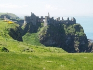
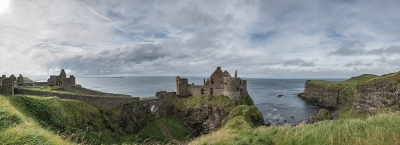
Dunluce Castle (from Irish ![]() : Dún Libhse) is a now-ruined medieval castle in Northern Ireland. It is located on the edge of a basalt outcropping in County Antrim (between Portballintrae and Portrush), and is accessible via a bridge connecting it to the mainland. The castle is surrounded by extremely steep drops on either side, which may have been an important factor to the early Christians and Vikings who were drawn to this place where an early Irish fort once stood.
: Dún Libhse) is a now-ruined medieval castle in Northern Ireland. It is located on the edge of a basalt outcropping in County Antrim (between Portballintrae and Portrush), and is accessible via a bridge connecting it to the mainland. The castle is surrounded by extremely steep drops on either side, which may have been an important factor to the early Christians and Vikings who were drawn to this place where an early Irish fort once stood.
Dunluce Castle served as the seat of the Earl of Antrim until the impoverishment of the MacDonnells in 1690, following the Battle of the Boyne. Since that time, the castle has deteriorated and parts were scavenged to serve as materials for nearby buildings.
Information about copyright | |
|---|---|
Rights characteristic / license | by-sa: CREATIVE COMMONS Attribution-ShareAlike |
Link to the description of the license | |
Input taken over from: |
Wikipedia contributors, 'Dunluce Castle', Wikipedia, The Free Encyclopedia, 11 November 2018, 03:00 UTC, <https://en.wikipedia.org/w/index.php?title=Dunluce_Castle&oldid=868263954> [accessed 15 January 2019] |
taken over / edited on | 15 Jan 2019
|
taken over / edited by |
|
Nearby cycle routes and tours
| Route name | Type | Dist. to route |
|---|---|---|
Route | 0,3 km | |
Tour | 0,1 km | |
Tour | 0,3 km |
Added on 15 Jan 2019,
last edited by biroto-Redaktion on 15 Jan 2019