
Ironbridge
Worth visiting
Added on 23 Apr 2017,
last edited by biroto-Redaktion on 23 Apr 2017
Nearby cycle routes and tours
| Route name | Type | Dist. to route |
|---|---|---|
Route | 0,0 km | |
Route | 2,1 km |
![]()
Please wait - map data are loading
Type of sights
Industrial heritage / World heritage site
Name and address
Ironbridge
GB-TF8 Ironbridge
GEO-data
Geodetic coordinates
52.62∎∎∎∎ -2.48∎∎∎∎
Elevation
37 m
Communication
Information about copyright | |
|---|---|
Rights owner | |
Rights characteristic / license | by-sa: CREATIVE COMMONS Attribution-ShareAlike |
Link to the description of the license | |
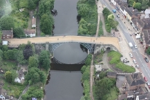
Image taken over from | https://commons.wikimedia.org/wiki/File:The_Iron_Bridge_(Aerial).JPG |
Image has been uploaded | by biroto-Redaktion on 23 Apr 2017
|
Information about copyright | |
|---|---|
Rights owner | |
Rights characteristic / license | by-sa: CREATIVE COMMONS Attribution-ShareAlike |
Link to the description of the license | |
Image taken over from | |
Image has been uploaded | by biroto-Redaktion on 23 Apr 2017
|
Information about copyright | |
|---|---|
Rights owner | |
Rights characteristic / license | by: CREATIVE COMMONS Attribution |
Link to the description of the license | |
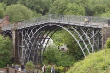
Image taken over from | https://commons.wikimedia.org/wiki/File:Ironbridge_5_(5381983836).jpg |
Image has been uploaded | by biroto-Redaktion on 23 Apr 2017
|
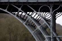
The Iron Bridge is a bridge that crosses the River Severn ![]() in Shropshire, England. Opened in 1781, it was the first major bridge in the world to be made of cast iron, and was greatly celebrated after construction owing to its use of the new material.
in Shropshire, England. Opened in 1781, it was the first major bridge in the world to be made of cast iron, and was greatly celebrated after construction owing to its use of the new material.
In 1934 it was designated a Scheduled Ancient Monument and closed to vehicular traffic. Tolls for pedestrians were collected until 1950, when ownership of the bridge was transferred to Shropshire County Council. It now belongs to Telford and Wrekin Borough Council. The bridge, the adjacent settlement of Ironbridge and the Ironbridge Gorge form the UNESCO Ironbridge Gorge World Heritage Site. The bridge is a Grade I listed building, and a waypoint on the South Telford Heritage Trail.
Abraham Darby I first smelted local iron ore with coke made from Coalbrookdale coal in 1709, and in the coming decades Shropshire became a centre for industry due to the low price of fuel from local mines. The River Severn was used as a key trading route, but it was also a barrier to travel around the deep Severn Gorge, especially between the then important industrial parishes of Broseley ![]() and Madeley
and Madeley ![]() , the nearest bridge being at Buildwas
, the nearest bridge being at Buildwas ![]() two miles away. The use of the river by boat traffic and the steep sides of the gorge meant that any bridge should ideally be of a single span, and sufficiently high to allow tall ships to pass underneath. The steepness and instability of the banks was problematic for building a bridge, and there was no point where roads on opposite sides of the river converged.
two miles away. The use of the river by boat traffic and the steep sides of the gorge meant that any bridge should ideally be of a single span, and sufficiently high to allow tall ships to pass underneath. The steepness and instability of the banks was problematic for building a bridge, and there was no point where roads on opposite sides of the river converged.
Information about copyright | |
|---|---|
Rights characteristic / license | by-sa: CREATIVE COMMONS Attribution-ShareAlike |
Link to the description of the license | |
Input taken over from: |
Wikipedia contributors, 'The Iron Bridge', Wikipedia, The Free Encyclopedia, 11 April 2017, 01:57 UTC, <https://en.wikipedia.org/w/index.php?title=The_Iron_Bridge&oldid=774852628> [accessed 23 April 2017] |
taken over / edited on | 23 Apr 2017
|
taken over / edited by |
|
Nearby cycle routes and tours
| Route name | Type | Dist. to route |
|---|---|---|
Route | 0,0 km | |
Route | 2,1 km |
Added on 23 Apr 2017,
last edited by biroto-Redaktion on 23 Apr 2017