
Cycle Route Inn-Radweg Tiroler Oberland
No. of cycle route R3
Actions
![]()
Please wait - map data are loading
Added on 04 May 2013,
last edited by biroto-Redaktion on 24 Oct 2023
Actions
Cycle route metrics
Total distance in km
115
Information about rights to the gps-track data | |
|---|---|
Rights owner | OpenStreetMap and Contributors + biroto-Redaktion (biroto.eu) |
Rights characteristic / license | Contains information from OpenStreetMap, which is made available here under the Open Database License(ODbL) |
Link to the description of the license | |
GPX file taken from | |
GPX file uploaded | by biroto-Redaktion on 24 Oct 2023
|
Track points in total
2.190
Track points per km (avg)
19
Start/endpoint
Start location
Pfunds, T, AT (981 m NHN)
End location
Innsbruck, T, AT (578 m NHN)
Signposting
|
|

Travel reports about cycle tours
Information about copyright | |
|---|---|
Rights owner | |
Rights characteristic / license | by-sa: CREATIVE COMMONS Attribution-ShareAlike |
Link to the description of the license | |
Image has been uploaded | by Ottocolor on 11 Aug 2014
|
25 Jul 2014
67 km
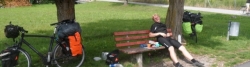
A stage of the tour »Bike holiday in the Alps 2014« of user Ottocolor
Information about copyright | |
|---|---|
Rights owner | |
Rights characteristic / license | by-sa: CREATIVE COMMONS Attribution-ShareAlike |
Link to the description of the license | |
Image has been uploaded | by Ottocolor on 12 Aug 2014
|
27 Jul 2014
80 km
A stage of the tour »Bike holiday in the Alps 2014« of user Ottocolor
Beds4Cyclists, worth visiting and infrastructure
Name and address
Latitude / Longitude
Phone
Fax
Mobile
Type of accommodation
Rating for cyclists
Route km
Dist. to route
Elevation
0 km
3,1 km
994 m
Information about copyright | |
|---|---|
Rights owner | |
Rights characteristic / license | by-sa: CREATIVE COMMONS Attribution-ShareAlike |
Link to the description of the license | |
Image taken over from | |
Image has been uploaded | by biroto-Redaktion on 28 Jul 2012
|
Information about copyright | |
|---|---|
Rights owner | |
Rights characteristic / license | by-sa: CREATIVE COMMONS Attribution-ShareAlike |
Link to the description of the license | |
Image taken over from | |
Image has been uploaded | by biroto-Redaktion on 28 Jul 2012
|
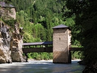
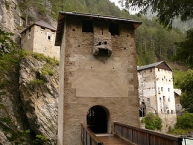
Finstermünz (heute Altfinstermünz, rätorom. Vestmezia) (49,929° N; 10,487° O) (am Finstermünzpass) gehört zum Gemeindegebiet und liegt dort, wo die bis 1854 benutzte alte Straße vom Reschenpass in Richtung Pfunds-Landeck den Inn erreicht, der die Grenze zur Schweiz bildet. Hier war bereits vor dem 10. Jahrhundert ein Gerichtssitz. Heute steht Finstermünz im Abseits: Die im 15. Jahrhundert von Herzog Sigmund angelegte Grenzbefestigung Sigismundseck, die aussieht, wie an den Felsen geklebt; der mitten im Inn stehende Wehrturm mit den beidseitigen Holzbrücken; eine kleine Kapelle und das alte Zollhaus. Die Zollstätte wurde 1779 mit der österreichischen Zollreform, die die Binnenzölle aufhob, aufgelassen und in Richtung Martinsbruck verlegt.
Die Gebäude werden derzeit durch den 2001 gegründeten Verein Altfinstermünz renoviert.
Information about copyright | |
|---|---|
Rights characteristic / license | by-sa: CREATIVE COMMONS Attribution-ShareAlike |
Link to the description of the license | |
Input taken over from: |
Seite „Nauders“. In: Wikipedia, Die freie Enzyklopädie. Bearbeitungsstand: 11. Juni 2012, 16:46 UTC. URL: http://de.wikipedia.org/w/index.php?title=Nauders&oldid=104274750 (Abgerufen: 28. Juli 2012, 12:56 UTC) |
taken over / edited on | 28 Jul 2012
|
taken over / edited by |
|
0 km
0,1 km
987 m
Bushaltestelle Linie 210 Landeck - Nauders
Postbus transportiert auch Fahrräder.
Anfang Mai bis Ende September Abfahrt ca. stündlich. E-Bikes nur vier mal täglich, wenn Bus mit Anhänger.
Information about copyright | |
|---|---|
Rights characteristic / license | by-sa: CREATIVE COMMONS Attribution-ShareAlike |
Link to the description of the license | |
taken over / edited on | 27 Sep 2012 - 10 Dec 2018
|
taken over / edited by |
|
4 km
0,0 km
968 m
4 km
0,0 km
975 m
4 km
0,1 km
976 m
![]()