
Cycle Route Kamp-Thaya-March Radweg
No. of cycle route 8
Actions
![]()
Please wait - map data are loading
Added on 18 Jan 2012,
last edited by biroto-Redaktion on 26 Oct 2023
Actions
Cycle route metrics
Total distance in km
421
Information about rights to the gps-track data | |
|---|---|
Rights owner | OpenStreetMap and Contributors + biroto-Redaktion (biroto.eu) |
Rights characteristic / license | Contains information from OpenStreetMap, which is made available here under the Open Database License(ODbL) |
Link to the description of the license | |
GPX file taken from | |
GPX file uploaded | by biroto-Redaktion on 26 Oct 2023
|
Track points in total
6.960
Track points per km (avg)
17
Start/endpoint
Start location
Krems an der Donau, NÖ, AT (198 m NHN)
End location
Engelhartstetten, NÖ, AT (145 m NHN)
Signposting
|
|

Beds4Cyclists, worth visiting and infrastructure
Name and address
Latitude / Longitude
Phone
Fax
Mobile
Type of accommodation
Rating for cyclists
Route km
Dist. to route
Elevation
0 km
0,4 km
207 m
Information about copyright | |
|---|---|
Rights owner | |
Rights characteristic / license | by-sa: CREATIVE COMMONS Attribution-ShareAlike |
Link to the description of the license | |
Image taken over from | https://commons.wikimedia.org/wiki/File:Blick_auf_die_Altstadt_von_Krems.jpg |
Image has been uploaded | by biroto-Redaktion on 13 Jan 2015
|
Information about copyright | |
|---|---|
Rights owner | |
Rights characteristic / license | by-sa: CREATIVE COMMONS Attribution-ShareAlike |
Link to the description of the license | |
Image taken over from | |
Image has been uploaded | by biroto-Redaktion on 13 Jan 2015
|
Information about copyright | |
|---|---|
Rights owner | |
Rights characteristic / license | by-sa: CREATIVE COMMONS Attribution-ShareAlike |
Link to the description of the license | |
Image taken over from | |
Image has been uploaded | by biroto-Redaktion on 13 Jan 2015
|
Information about copyright | |
|---|---|
Rights owner | |
Rights characteristic / license | by-sa: CREATIVE COMMONS Attribution-ShareAlike |
Link to the description of the license | |
Image taken over from | https://commons.wikimedia.org/wiki/File:Piaristenkirche_Krems.jpg |
Image has been uploaded | by biroto-Redaktion on 13 Jan 2015
|
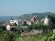
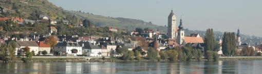
Krems an der Donau is a riverside town in the Danube's Wachau Valley tourist region of Lower Austria.
Understand
Krems, along with neighboring cities Stein, Egelsee, Dürnstein and Spitz an der Donau are known for their world class wine production as well as their proximity to the Danube.
See
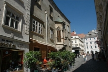
The historic town center of Krems is well-worth exploring. The old town of Krems belongs to the UNESCO World Heritage Site "Wachau Cultural Landscape", established in 2000.
- ⊙Steiner Tor, Obere Landstraße. One of the old city gates, dating from the 15th century.
- ⊙Museumkrems, Körnermarkt 14, ☎ +43 2732 801567. Apr-May W-Su, holidays 11:00-18:00; Jun-Oct Daily 11:00-18:00; closed Nov-Mar. Has well-curated permanent exhibits illustrating the history of Krems and the wider region, and hosts temporary exhibits of contemporary art. €5 (adults), €4 (concessions), free (children/youth under 19).
- ⊙Gozzoburg, Hoher Markt 11. Built in the 13th century, this is one of the most significant medieval city buildings in Austria, and is now used for special exhibits. In 2006 and 2007 restoration work uncovered a remarkable set of 13th-century frescoes; along with the Iwein frescoes in Thüringen, Germany, these are the only surviving indoor 13th-century murals north of the Alps. The murals can be viewed only with a guided tour, arranged through the Museumkrems.
- Jewish Cemetery Krems (Jüdischer Friedhof Krems), Wiener Straße. Established in 1880 for the Jewish community of Krems, the cemetery was abandoned in 1936 and now is a memorial under the auspices of Vienna Israelite Community. Located on the grounds is a 42m-long metal memorial by Hans Kupelwieser, engraved with the names of the Krems Jews who died during the Holocaust. In 2004 the Irish/Israeli artist duo of Clegg & Guttmann installed three public bookshelves as another memorial.
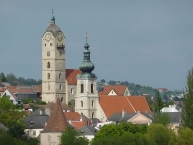
- ⊙Piaristenkirche (Kremser Frauenbergkirche), Piaristengasse 1, ☎ +43 2732 82092. The oldest church in Krems. The earliest foundations date to the 13th century, while the current structure is from the late Gothic period of the early 16th century. The interior was remodeled during the Baroque era.
Information about copyright | |
|---|---|
Rights characteristic / license | by-sa: CREATIVE COMMONS Attribution-ShareAlike |
Link to the description of the license | |
Input taken over from: |
Wikivoyage contributors, 'Krems', Wikivoyage, The FREE worldwide travel guide that anyone can edit, 29 August 2016, 10:22 UTC, https://en.wikivoyage.org/w/index.php?title=Krems&oldid=3041787 |
taken over / edited on | 28 Sep 2016 - 03 Apr 2022
|
taken over / edited by |
|
0 km
2,8 km
204 m
0 km
2,0 km
203 m
Information about copyright | |
|---|---|
Rights owner | |
Rights characteristic / license | by: CREATIVE COMMONS Attribution |
Link to the description of the license | |
Image taken over from | https://commons.wikimedia.org/wiki/File:Stein_a_d_Donau_Panorama.jpg |
Image has been uploaded | by biroto-Redaktion on 13 Jan 2015
|
Information about copyright | |
|---|---|
Rights owner | |
Rights characteristic / license | by-sa: CREATIVE COMMONS Attribution-ShareAlike |
Link to the description of the license | |
Image taken over from | https://commons.wikimedia.org/wiki/File:Stein_Rathausplatz_Johannes_Nepomuk.jpg |
Image has been uploaded | by biroto-Redaktion on 13 Jan 2015
|
Information about copyright | |
|---|---|
Rights owner | |
Rights characteristic / license | by-sa: CREATIVE COMMONS Attribution-ShareAlike |
Link to the description of the license | |
Image taken over from | |
Image has been uploaded | by biroto-Redaktion on 13 Jan 2015
|
Information about copyright | |
|---|---|
Rights owner | |
Rights characteristic / license | by-sa: CREATIVE COMMONS Attribution-ShareAlike |
Link to the description of the license | |
Image taken over from | |
Image has been uploaded | by biroto-Redaktion on 13 Jan 2015
|
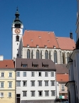
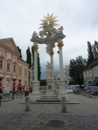
Stein an der Donau ist ein Stadtteil von Krems an der Donau ![]() . Jahrhundertelang war es eine eigene Stadt und wurde erst 1938 an Krems angeschlossen. Ebenso wie die Innenstadt von Krems gehört auch die Innenstadt von Stein an der Donau zum UNESCO-Weltkultur- und -naturerbe Wachau.
. Jahrhundertelang war es eine eigene Stadt und wurde erst 1938 an Krems angeschlossen. Ebenso wie die Innenstadt von Krems gehört auch die Innenstadt von Stein an der Donau zum UNESCO-Weltkultur- und -naturerbe Wachau.
Stein
- ⊙Ehemalige Frauenbergkirche
 : gotischer Bau des 14. Jahrhunderts, nach Restaurierung 1963–1965 als Denkmal der Gefallenen der beiden Weltkriege gewidmet.
 - ⊙Göttweigerhofkapelle: Kapelle des ehemaligen Wirtschaftshofs des Benediktinerstiftes Göttweig mit Kapelle und gotischen Fresken, datiert um 1300.
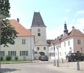
- ⊙Großer Passauerhof: Erstmals 1263 genannt, Zehenthof des Bischofs von Passau, Bau in heutiger Erscheinung zwischen 1550 und 1600 aus drei Einzelhäusern zusammengefasst.
- ⊙Haus der Regionen , das ehemalige Gasthaus Zum Goldenen Elephanten, Steiner Donaulände, 1721 erstmals schriftlich belegt.
- ⊙Kremser Tor: Östlicher Abschluss der mittelalterlichen Stadtbefestigung zur Stadt Krems hin. Erbaut um 1470.
- ⊙Linzer Tor: 1477 erbaut (Tafel mit gotischen Ziffern an der Außenseite eingemauert), im 18. Jahrhundert verändert.
- ⊙Mauthaus: Beeindruckende Freskendekorierung aus der Renaissance, dürfte das Wohnhaus des Brückenmautners gewesen sein, nicht aber das Mauthaus selbst. Dieses befand sich außerhalb des Linzertores im Westen der Stadt.
- ⊙Mazettihaus: Schürerplatz; benannt nach seinem Erbauer; war Wohnhaus Ludwig Ritter von Köchels (geb. 1800 in Stein), des Verfassers des Mozartverzeichnisses.
- ⊙Ehemalige Minoritenkirche: 1264 geweiht, heute Veranstaltungsraum Klangraum Krems und Museen (Forum Frohner, Ernst Krenek Forum, Kunstraum Stein) im anliegenden Klostergebäude.
- ⊙Pfarrkirche Hl. Nikolaus: Spätgotisch, datiert Ende 14./Ende 15. Jahrhundert, enthält mehrere Werke des Kremsers Schmidt.
- ⊙Salzstadl: Salzlagergebäude aus dem 16. Jahrhundert, Stein war auf Grund eines kaiserlichen Privilegs der Umschlagplatz des donauabwärts verschifften bayerischen und Salzburger Salzes für die Länder des nördlichen Mitteleuropas wie etwa Böhmen, Mähren, Schlesien usw.
- ⊙Steiner Rathaus: ab 1701 als Rathaus der Stadt Stein genutzt, Fassade aus 1779 von Johann Michael Ehmann.
Museen
- ⊙Karikaturmuseum, Steiner Landstraße 3a, A-3500 Krems-Stein, ☎ +43 2732 908020
- ⊙Kunsthalle, Franz-Zeller-Platz 3. 3500 Krems
Information about copyright | |
|---|---|
Rights characteristic / license | by-sa: CREATIVE COMMONS Attribution-ShareAlike |
Link to the description of the license | |
Input taken over from: |
|
taken over / edited on | 13 Jan 2015 - 28 Sep 2016
|
taken over / edited by |
|
0 km
4,8 km
424 m
Information about copyright | |
|---|---|
Rights owner | |
Rights characteristic / license | by-sa: CREATIVE COMMONS Attribution-ShareAlike |
Link to the description of the license | |
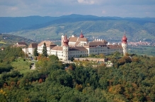
Image taken over from | https://commons.wikimedia.org/wiki/File:Benediktinerstift_Göttweig,_Luftbild_1.JPG |
Image has been uploaded | by biroto-Redaktion on 28 Sep 2016
|
Information about copyright | |
|---|---|
Rights owner | |
Rights characteristic / license | by-sa: CREATIVE COMMONS Attribution-ShareAlike |
Link to the description of the license | |
Image taken over from | |
Image has been uploaded | by biroto-Redaktion on 28 Sep 2016
|
Information about copyright | |
|---|---|
Rights owner | |
Rights characteristic / license | by-sa: CREATIVE COMMONS Attribution-ShareAlike |
Link to the description of the license | |
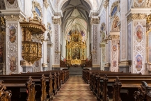
Image taken over from | https://commons.wikimedia.org/wiki/File:Stiftskirche_Göttweig_Innenraum_03.JPG |
Image has been uploaded | by biroto-Redaktion on 28 Sep 2016
|
Information about copyright | |
|---|---|
Rights owner | |
Rights characteristic / license | by-sa: CREATIVE COMMONS Attribution-ShareAlike |
Link to the description of the license | |
Image taken over from | |
Image has been uploaded | by biroto-Redaktion on 28 Sep 2016
|
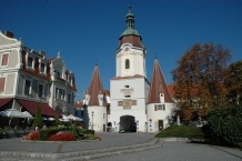
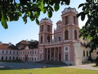
Das Stift Göttweig ist eine barocke Klosteranlage auf dem Göttweiger Berg in der Gemeinde Furth, wenige Kilometer südlich von Krems an der Donau (Niederösterreich).
Hintergrund
1083 wurde das Kloster als Augustiner-Chorherrenstift gegründet, aber 1094 den Benediktinern übergeben. Die ursprüngliche Anlage wurde 1580 durch einen Brand zerstört, aber wieder aufgebaut. Nach einem neuerlichen Brand 1718 wurde die heutige Anlage 1720 bis 1740 von Johann Lucas von Hildebrand erbaut.
Das Kloster liegt am nordöstlichen Eingang zur Kulturlandschaft Wachau und gehört zum Welterbe der UNESCO.
Sehenswürdigkeiten
Die Stiftskirche weist noch Teile des hochgotischen Chors auf, ein frübarockes Langhaus, aber eine klassizistische Fassade. das Stiegenhaus des Stifts mit Fresko von Paul Troger zählt zu den bedeutendsten Werken des Barock.
Weiter sind die Krypta und die Kunstsammlungen mit graphischem Kabinett im Kaisertrakt des Stifts sehenswert.
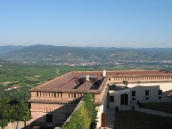
Von der Restaurantterasse genießt man einen großartigen Ausblick auf Krems und das Donautal mit der Wachau, im Osten bis zum Wienerwald.
Information about copyright | |
|---|---|
Rights characteristic / license | by-sa: CREATIVE COMMONS Attribution-ShareAlike |
Link to the description of the license | |
Input taken over from: |
Wikivoyage-Bearbeiter, 'Göttweig', Wikivoyage, Freie Reiseinformationen rund um die Welt, 15. August 2016, 06:32 UTC, <https://de.wikivoyage.org/w/index.php?title=G%C3%B6ttweig&oldid=948478> [abgerufen am 28. September 2016] |
taken over / edited on | 28 Sep 2016
|
taken over / edited by |
|
Hours of opening
Museum
19. März bis 1. November 2016:
BESICHTIGUNG ohne Führung: täglich von 10-18 Uhr (Juni bis September 9-18 Uhr)
Kassaschluss und letzter Einlass: 17 Uhr
Pforte & Klosterladen
Ab 19. März bis 26. Dezember 2016:
täglich 08:00 - 18:00 Uhr
0 km
2,9 km
203 m
![]()