
Cycle Route Mühlviertlerweg
No. of cycle route R5
Actions
![]()
Please wait - map data are loading
Added on 07 Feb 2012,
last edited by biroto-Redaktion on 02 Nov 2020
Actions
Cycle route metrics
Total distance in km
232
Information about rights to the gps-track data | |
|---|---|
Rights owner | OpenStreetMap and Contributors + biroto-Redaktion (biroto.eu) |
Rights characteristic / license | Contains information from OpenStreetMap, which is made available here under the Open Database License(ODbL) |
Link to the description of the license | |
GPX file taken from | |
GPX file uploaded | by biroto-Redaktion on 02 Nov 2020
|
Track points in total
5.343
Track points per km (avg)
23
Start/endpoint
Start location
Grein, Oberösterreich, AT (229 m NHN)
End location
Neustift im Mühlkreis, Oberösterreich, AT (290 m NHN)
Beds4Cyclists, worth visiting and infrastructure
Name and address
Latitude / Longitude
Phone
Fax
Mobile
Type of accommodation
Rating for cyclists
Route km
Dist. to route
Elevation
0 km
3,8 km
225 m
0 km
0,0 km
239 m
0 km
0,1 km
245 m
0 km
0,1 km
242 m
Information about copyright | |
|---|---|
Rights owner | |
Rights characteristic / license | by-sa: CREATIVE COMMONS Attribution-ShareAlike |
Link to the description of the license | |
Image taken over from | |
Image has been uploaded | by biroto-Redaktion on 12 Jan 2015
|
Information about copyright | |
|---|---|
Rights owner | |
Rights characteristic / license | by-sa: CREATIVE COMMONS Attribution-ShareAlike |
Link to the description of the license | |
Image taken over from | https://commons.wikimedia.org/wiki/File:Grein_Donaublick.jpg |
Image has been uploaded | by biroto-Redaktion on 12 Jan 2015
|
Information about copyright | |
|---|---|
Rights owner | |
Rights characteristic / license | by-sa: CREATIVE COMMONS Attribution-ShareAlike |
Link to the description of the license | |
Image taken over from | |
Image has been uploaded | by biroto-Redaktion on 12 Jan 2015
|
Information about copyright | |
|---|---|
Rights owner | |
Rights characteristic / license | by-sa: CREATIVE COMMONS Attribution-ShareAlike |
Link to the description of the license | |
Image taken over from | |
Image has been uploaded | by biroto-Redaktion on 12 Jan 2015
|
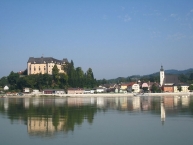
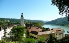
Grein ist eine oberösterreichische Stadtgemeinde im Unteren Mühlviertel im Bezirk Perg
Bauwerke
- Historisches Stadttheater Grein
 : Rokoko-Bau von 1791, ältestes original erhaltenes bürgerliches Theater Österreichs. Es beherbergt auch eine Theaterausstellung.
 - Schloss Greinburg : erhielt seine jetzige geschlossene Form im frühen 17. Jahrhundert. Sehenswert sind der harmonische dreigeschossige Arkadenhof, die Prunkräume, die Kapelle mit dem Marmoraltar und das steinerne Theater Sala terrena. Im Schloss befindet sich auch das "Oberösterreichische Schifffahrtsmuseum".
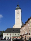
- Pfarrkirche Sankt Ägidius: spätgotische, jedoch stark erneuerte Hallenkirche. Barocker Hochaltar von 1749 mit einem Gemälde von Bartolomeo Altomonte
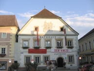
- Altes Rathaus (1563), bis heute in seiner ursprünglichen Form erhalten. Ursprünglich ein Getreidespeicher wurde das Gebäude 1791 in ein Bürgertheater (heute: Stadttheater) umgewandelt. Im Rahmen der Greiner Sommerfestspiele finden nach wie vor regelmäßig Aufführungen statt
- Ortskern: Ensemble von Häusern aus dem 16. und 17. Jahrhundert, mit überwiegend barocken Fassaden.
- Cafe Blumensträußl befindet sich in einem der ältesten Häuser, Innen-Einrichtung im Biedermeier-Stil
- Gobelwarte , Aussichtsplattform
- Eisenbahn-Viadukt der Donauuferbahn mit sieben Bögen über den Gießenbach am Eingang zur Stillensteinklamm
Museum
- Oberösterreichisches Schifffahrtsmuseum : im Schloss Greinburg; das Museum gibt einen Überblick über die Entwicklung der Schifffahrt auf der Donau.
Information about copyright | |
|---|---|
Rights characteristic / license | by-sa: CREATIVE COMMONS Attribution-ShareAlike |
Link to the description of the license | |
Input taken over from: |
Seite „Grein“. In: Wikipedia, Die freie Enzyklopädie. Bearbeitungsstand: 18. Dezember 2014, 15:53 UTC. URL: http://de.wikipedia.org/w/index.php?title=Grein&oldid=136899938 (Abgerufen: 12. Januar 2015, 17:41 UTC) |
taken over / edited on | 12 Jan 2015
|
taken over / edited by |
|
8 km
0,0 km
456 m
![]()