
Cycle Route Zillertal-Radweg
No. of cycle route R13
Actions
![]()
Please wait - map data are loading
Added on 05 Sep 2012,
last edited by biroto-Redaktion on 19 Jan 2024
Actions
Cycle route metrics
Total distance in km
30
Information about rights to the gps-track data | |
|---|---|
Rights owner | OpenStreetMap and Contributors + biroto-Redaktion (biroto.eu) |
Rights characteristic / license | Contains information from OpenStreetMap, which is made available here under the Open Database License(ODbL) |
Link to the description of the license | |
GPX file taken from | |
GPX file uploaded | by biroto-Redaktion on 19 Jan 2024
|
Track points in total
517
Track points per km (avg)
17
Start/endpoint
Start location
Mayrhofen, Tirol, AT (626 m NHN)
End location
Strass im Zillertal, Tirol, AT (524 m NHN)
Beds4Cyclists, worth visiting and infrastructure
Name and address
Latitude / Longitude
Phone
Fax
Mobile
Type of accommodation
Rating for cyclists
Route km
Dist. to route
Elevation
0 km
0,3 km
623 m
29 km
0,8 km
561 m
29 km
4,3 km
526 m
Information about copyright | |
|---|---|
Rights owner | Herbert Ortner |
Rights characteristic / license | by-sa: CREATIVE COMMONS Attribution-ShareAlike |
Link to the description of the license | |
Image taken over from | |
Image has been uploaded | by Ottocolor on 10 May 2014
|
Information about copyright | |
|---|---|
Rights owner | Siegele Roland |
Rights characteristic / license | by-sa: CREATIVE COMMONS Attribution-ShareAlike |
Link to the description of the license | |
Image taken over from | |
Image has been uploaded | by Ottocolor on 10 May 2014
|
Information about copyright | |
|---|---|
Rights owner | Flickr upload bot |
Rights characteristic / license | by-sa: CREATIVE COMMONS Attribution-ShareAlike |
Link to the description of the license | |
Image taken over from | commons.wikimedia.org/wiki/File:Achenseebahn_above_Jenbach.jpg |
Image has been uploaded | by Ottocolor on 10 May 2014
|
Information about copyright | |
|---|---|
Rights owner | Haneburger |
Rights characteristic / license | by-sa: CREATIVE COMMONS Attribution-ShareAlike |
Link to the description of the license | |
Image taken over from | |
Image has been uploaded | by Ottocolor on 10 May 2014
|
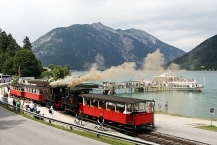
The Achensee Railway (German: Achenseebahn) is a 6.78 kilometres (4.21 mi) long metre gauge railway running between Jenbach ![]() and Seespitz on Lake Achensee
and Seespitz on Lake Achensee ![]() in Tyrol (Austria). Within its length it rises some 440 metres (1,444 ft) in height, with the steeper sections using the Riggenbach rack system. It is Europe's oldest cog railway which is still steam operated.
in Tyrol (Austria). Within its length it rises some 440 metres (1,444 ft) in height, with the steeper sections using the Riggenbach rack system. It is Europe's oldest cog railway which is still steam operated.
History
In 1886, Theodor Friedrich Freiherr von Dreifuss proposed to connect Jenbach to the Achensee. Despite concerns by villagers in the area, the proposal was supported by the monastery ![]() at Fiecht, which owned the Achensee and ran steam boats on the lake.
at Fiecht, which owned the Achensee and ran steam boats on the lake.
Consent to build the line was given on 1 August 1888 by Emperor Franz Josef. The line was constructed by the Soenderop Company of Berlin. The official opening of the line was on 8 June 1889. The line originally ended a short distance short of the pier for the steamboats as it was intended to run a luggage service between Seespitz station and the pier at an extra charge. The railway was extended to a new station serving the steamboats in 1916.
The railway carried its highest numbers of passengers during World War IIand after the war the railway was an important method of supplying the region with goods and materials. In 1950, the Tirolean Water Company (TIWAG) acquired a majority of the shares in the railway, passing them to the villages of Achenkirch, Maurach and Eben in 1979. Carriage of freight ceased in 1973. The railway was remodelled with support from TIWAG, the Federal Government and State Government.
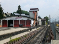
On 16 May 2008, the engine shed at Jenbach railway station was destroyed in a fire. Locomotives No.1 was damaged, but will be restored, as will the engine shed. Already at the season opening 2009 the shed has been completed and the No.1 was rebuilt.
Infrastructure
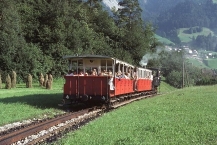
The 6.78 km route has a track gauge of 1,000 mm (3 ft 3 3⁄8 in). It runs between Jenbach and Achensee Schiffstation. The Riggenbach rack system is installed between Jenbach and Eben, from which point the line descends gently to Achensee Schiffstation. Upwards trains propel to Maurach, where the engine runs round and hauls the coaches to the Achensee terminal. The engine leads throughout on the downward journey.
Information about copyright | |
|---|---|
Rights characteristic / license | by-sa: CREATIVE COMMONS Attribution-ShareAlike |
Link to the description of the license | |
Input taken over from: |
http://en.wikipedia.org/w/index.php?title=Achensee_Railway&oldid=604442350 |
taken over / edited on | 10 May 2014
|
taken over / edited by |
|
Hours of opening
Main season May, 9th to October, 5th 2014
| Jenbach - Bahnhof | 8.15 | 10.00 | 10.45 | 12.00 | 13.45 | 15.00 | 16.45 | |
| Burgeck | 8.22 | 10.07 | 10.52 | 12.07 | 13.52 | 15.07 | 16.52 | |
| Eben | 8.47 | 10.35 | 11.20 | 12.35 | 13.35 | 14.20 | 15.35 | 17.20 |
| Maurach | 8.50 | 10.38 | 11.23 | 12.38 | 13.38 | 14.23 | 15.38 | 17.23 |
| Maurach Mitte | 8.53 | 10.41 | 11.26 | 12.41 | 13.41 | 14.26 | 15.41 | 17.26 |
| Seespitz - Bahnstation | 9.00 | 10.50 | 11.35 | 12.50 | 13.50 | 14.35 | 15.50 | 17.35 |
| Seespitz - Bahnstation | 9.15 | 11.05 | 12.20 | 13.05 | 14.05 | 15.20 | 16.00 | 17.40 |
| Maurach Mitte | 9.22 | 11.12 | 12.27 | 13.12 | 14.12 | 15.27 | 16.07 | 17.47 |
| Maurach | 9.25 | 11.15 | 12.30 | 13.15 | 14.15 | 15.30 | 16.10 | 17.50 |
| Eben | 9.28 | 11.18 | 12.33 | 13.18 | 14.18 | 15.33 | 16.13 | 17.53 |
| Burgeck | 9.49 | 11.39 | 12.54 | 14.39 | 15.54 | 16.34 | 18.14 | |
| Jenbach Bahnhof | 9.57 | 11.47 | 13.02 | 14.47 | 16.02 | 16.42 | 18.22 |
The Achensee cog railway will also take your bicycles. A booking in advance is necessary, though!
30 km
4,3 km
534 m
30 km
2,9 km
556 m
Languages spoken:
Deutsch
![]()