Cycle Route Ravel 1
No. of cycle route 1
Actions
![]()
Please wait - map data are loading
Added on 03 Feb 2016,
last edited by InduKult on 03 Feb 2016
Actions
Cycle route metrics
Total distance in km
327
Information about rights to the gps-track data | |
|---|---|
Rights owner | |
Rights characteristic / license | cc0: Public Domain no Rights reserved |
Link to the description of the license | |
GPX file uploaded | by biroto-Redaktion on 19 Oct 2023
|
Track points in total
4.065
Track points per km (avg)
12
Start/endpoint
Start location
Comines-Warneton, WAL, BE (14 m NHN)
End location
Visé, WAL, BE (74 m NHN)
Character
The RAVEL 1 is the West-East-Main Route in Wallonia. He uses
- in the Western part formerly Railrods,
- from Kortrijk the Canal Kortrijk-Bossuit,
- l'Escaut until Tournai
- Canal du Centre until la Louviere,
- the Canal Brüssel-Charleroi.
- from Charleroi the Ricver Sambre,
- from Namur the River Maas.
Information about copyright | |
|---|---|
Rights characteristic / license | by-sa: CREATIVE COMMONS Attribution-ShareAlike |
Link to the description of the license | |
taken over / edited on | 03 Feb 2016
|
taken over / edited by |
|
Landscape
Abwechslungsreich, dicht besiedelt, teils stark industrialisiert (Schelde, Canal du Centre, Sambre, Maas), viele Bahnanschlüsse.
Information about copyright | |
|---|---|
Rights characteristic / license | by-sa: CREATIVE COMMONS Attribution-ShareAlike |
Link to the description of the license | |
taken over / edited on | 03 Feb 2016
|
taken over / edited by |
|
Travel to and from ...
Kortrijk oder Lille per Bahn. Ab Lanaye/Maastricht/Vise ebenfalls Bahnanschluss.
Connecting cycle path
- Maas-Radweg in Süd-Limburg (NL),
- Maas-Radweg (Ravel 2) durch die Ardennen ab Namur bzw. nach Tienen,
- ab Charleroi Ravel 8 an der oberen Sambre bis Maubeuge
- Ravel 3b von La Louviere nach Brüssel-Antwerpen,
- Ravel 98pp ab Mons durch die Borinage,
- Ravel 4 ab Blaton Richtung Aalst-Brüssel,
- Ravel 1a West an der Schelde Richtung Gent-Antwerpen
- am Westende Richtung Lille/Calais/Dünkirchen/Brügge (LF1, LF6).
Remarks
Herzstück des wallonischen Radwegenetzes in sehr kurzweiliger und kontrastreicher Landschaft. Autofrei, flach und fast druchgehend asphaltiert.
RAVEL 8 "TransWallonie" benutzt im westlichen Teil weitgehend die gleichen Wege; nur Charleroi wird südlich umfahren. Erst in Liège trennen sich diese beiden Routen: RAVEL 1 folgt weiter der Maas abwärts, während Ravel 8 über Ourthe, Ambleve, Ligne 45 und Vennbahntrasse nach Luxemburg geführt wird.
Beds4Cyclists, worth visiting and infrastructure
Name and address
Latitude / Longitude
Phone
Fax
Mobile
Type of accommodation
Rating for cyclists
Route km
Dist. to route
Elevation
30 km
0,5 km
19 m
Information about copyright | |
|---|---|
Rights owner | |
Rights characteristic / license | by-sa: CREATIVE COMMONS Attribution-ShareAlike |
Link to the description of the license | |
Image taken over from | https://commons.wikimedia.org/wiki/File:Courtrai_beguinage.jpg |
Image has been uploaded | by biroto-Redaktion on 14 Mar 2018
|
Information about copyright | |
|---|---|
Rights owner | |
Rights characteristic / license | by-sa: CREATIVE COMMONS Attribution-ShareAlike |
Link to the description of the license | |
Image taken over from | https://commons.wikimedia.org/wiki/File:Kortrijk_Stadhuis_R01.jpg |
Image has been uploaded | by biroto-Redaktion on 14 Mar 2018
|
Information about copyright | |
|---|---|
Rights owner | |
Rights characteristic / license | by-sa: CREATIVE COMMONS Attribution-ShareAlike |
Link to the description of the license | |
Image taken over from | |
Image has been uploaded | by biroto-Redaktion on 14 Mar 2018
|
Information about copyright | |
|---|---|
Rights owner | |
Rights characteristic / license | by-sa: CREATIVE COMMONS Attribution-ShareAlike |
Link to the description of the license | |
Image taken over from | https://commons.wikimedia.org/wiki/File:Kortrijk_Broeltürme_3.jpg |
Image has been uploaded | by biroto-Redaktion on 14 Mar 2018
|
Kortrijk (French: Courtrai, sometimes referred to in English as Courtray) is a city in Flanders, the northern part of Belgium. It is the capital and biggest city of the arrondissement of Kortrijk, which comprises some 284,581 inhabitants (1 January 2014). The wider municipality comprises the city of Kortrijk proper and the towns of Aalbeke, Bellegem, Bissegem, Heule, Kooigem, Marke, and Rollegem.
The city is situated on the Leie River, 42 km (26 miles) southwest of Ghent ![]() and 25 km (15 miles) northeast of Lille
and 25 km (15 miles) northeast of Lille ![]() in France. Both Kortrijk and Lille are part of the same transnational Eurodistrict urban area with around 1,900,000 inhabitants.
in France. Both Kortrijk and Lille are part of the same transnational Eurodistrict urban area with around 1,900,000 inhabitants.
As the biggest city of southern West Flanders, Kortrijk has many schools, a university, hospitals and shopping streets.
Understand
Kortrijk is a medium city, it has a good balance of tradition and innovation/modernism. It has always been famous for shopping, and in 2010 a big shopping centre was opened in the heart of the city. There are numerous traffic-free shopping zones, and lots historical sites in the city centre. Outside the centre there are some less developed hoods, but never really bad neighbourhoods.
Kortrijk is a rather safe city. Suburbs/satellite cities like Menen have to endure mainly burglary criminality from youth and gangsters, but Kortrijk is rather safe.
The city is known as the Guldensporenstad (City of the Golden Spurs), after the battle of the Golden Spurs in 1302. It used to be the centre of the linen industry and is still known as an important textile industry region.
See
Museums
- ⊙Kortrijk 1302, Begijnhofpark, ☎ +32 56 277850. May-Sept: Tue-Sun: 10:00—18:00. Closed on Mondays. Oct-Apr: Tue-Sun: 10:00—18:00. Closed on Mondays. An interactive museum showing you the Battle of the Golden Spurs (11th of July 1302). This battle is historical because it was one of the first battles where a peasant-based army defeated a knights army. After the battle, the spurs of the fallen horses were kept as a victory sign. The battle gave Flanders its regional holiday. €6 normal ticket. €4 reduced ticket. Free for children up to 12. (updated May 2017)
- Broelmuseum (Museum of Fine Arts). Situated in an old 18th-century mansion. Mostly contains regional artists (f.i. Roelant Savery) and an unique collection of ceramic. Closed for renewal. Will open in 2018 with a different name and concept. (updated May 2017)
- ⊙Texture (Museum of Flax and river Lys), Noordstraat 28, ☎ +32 56 277470. May-Sept: Tue-Sun: 10:00—18:00. Closed on Mondays. Oct-Apr: Tue-Sun: 10:00—17:00. Closed on Mondays. New museum that opened in 2014 on the banks of the Lys (Leie) river. Shows a historical image of the flax industry in Kortrijk and the surroundings. €6 normal ticket. €4 reduced ticket. Free for children up to 12. (updated May 2017)
- Groeninge Abbey.
- Agricultural Museum. In Bissegem.
Historical buildings
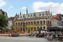
- ⊙City Hall (Stadhuis), ☎ +32 56 277000. (updated Jun 2017)
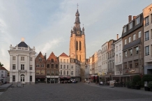
- ⊙Belfry (Belfort), Grote Markt.
 UNESCO World Heritage site
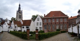
 - ⊙Begijnhof. The scenic beguinage (UNESCO-heritage) was founded in 1238 by Johanna Van Constantinopel. It was destroyed 3 times and rebuilt for the last time in the 17th century.
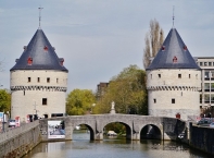
- ⊙Broeltorens. These two identical towers are remains of the medieval city wall. They are the typical image of Kortrijk. Build in the 13th and 15 century, they are located at both sides of the Leie river.
- Onze-Lieve-Vrouwehospitaal. Hospital, founded between 1200 and 1204.
- Baggaertshof. Medical garden and 13 old houses.
- ⊙Groeningepoort and Groeningekouter, Plein. The Groeningepoort gate is built in 1908 to commemorate the 600th anniversary of the Golden Spurs battle on the location of the Groeningekouter, the field of the battle took place. In the park that now covers a part of the former battle field, you can also find the Groeningemonument.
- ⊙Schouwburg, Schouwburgplein 14, ☎ +32 56 239855. A rather impressive, chateau-like building. Schouwburg is the Dutch word for theatre. (updated Jun 2017)
- ⊙The Wave Fountain (Fontein De Golf), Schouwburgplein (Near the theatre). Made by Olivier Strebelle.
Churches
Information about copyright | |
|---|---|
Rights characteristic / license | by-sa: CREATIVE COMMONS Attribution-ShareAlike |
Link to the description of the license | |
Input taken over from: |
Wikivoyage contributors, 'Kortrijk', Wikivoyage, The FREE worldwide travel guide that anyone can edit, 13 January 2019, 07:20 UTC, <https://en.wikivoyage.org/w/index.php?title=Kortrijk&oldid=3691741> [accessed 24 January 2019] |
taken over / edited on | 14 Mar 2018 - 24 Jan 2019
|
taken over / edited by |
|
40 km
5,0 km
28 m
73 km
0,2 km
14 m
154 km
1,4 km
101 m
178 km
4,6 km
96 m
Information about copyright | |
|---|---|
Rights owner | |
Rights characteristic / license | by-sa: CREATIVE COMMONS Attribution-ShareAlike |
Link to the description of the license | |
Image taken over from | |
Image has been uploaded | by biroto-Redaktion on 01 Apr 2015
|
Information about copyright | |
|---|---|
Rights owner | |
Rights characteristic / license | by-sa: CREATIVE COMMONS Attribution-ShareAlike |
Link to the description of the license | |
Image taken over from | |
Image has been uploaded | by biroto-Redaktion on 01 Apr 2015
|
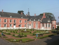
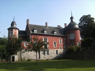
Cartier Castle (French: Château Bilquin de Cartier) is a château in Marchienne-au-Pont , a part of Charleroi
, in the province of Hainaut, Belgium.
Origins of the château can be traced back to the 17th century, around 1635, when the Honoré family builds a castle on the Sambre river bank. The place had formerly been occupied by a seigneurial manor which was dertroyed on 21 July 1554.
In 1667, the unfinished Spanish fortress of Charleroy is captured by Louis XIV's troops during the War of Devolution. As the castle in Marchienne was located in neutral territory (under authority of the Prince-Bishopric of Liège), it was used as a hospital for both French and Spanish soldiers.
In 1695, the castle is bought by Guillaume de Bilquin, a wealthy forge owner, who completes and enhances it. In 1717, his daughter, Marie-Agnès Bilquin, marries Jean-Louis Cartier, son of the general treasurer of the prince-bishop of Liège. As such, the castle becomes the property of the Cartier de Marchienne family.
In 1740, the castle hosts Remacle Le Loup, a famous draftsman from the Liège region. It is severely damaged by a fire in 1932, and bought over by the municipality of Marchienne-au-Pont in 1938, ending more than two centuries of ownership by the Cartier family.
Marguerite Yourcenar, a Belgian-born French novelist and essayist, and the first woman elected to the Académie française, is the daughter of Fernande de Cartier de Marchienne, from the Cartier family related to the Cartier castle. She visited the castle in Marchienne-au-Pont in 1956, and mentions her Cartier de Marchienne ancestry and the castle in her 1974 memoir Dear Departed: A Memoir (French: Souvenirs pieux).
Current condition
The castle today hosts a public library on the ground floor (Bibliothèque Marguerite Yourcenar), and administrative services of the Walloon region on the first floor. The library has a section dedicated to books in Turkish language.
The courtyard is equipped with benches and is publicly accessible as part of the Marchienne-au-Pont municipal park. The castle wing which was located on the southern side of the courtyard has been demolished to create an entrance for the De Cartier station of the Charleroi metro. At the tip of the western wing, a stone porch is adorned with the arms of the Bilquin-Baillencourt family, and a 1699 date inscription. Similarly, the lintel above the northern wing door shows a scalloped key with the arms of the Cartier family. Other demolished features include a barnyard where the Marchienne-au-Pont municipal swimming pool now stands.
A 19th century grain elevator in neo-renaissance style can be seen on the Sambre embankment.
Information about copyright | |
|---|---|
Rights characteristic / license | by-sa: CREATIVE COMMONS Attribution-ShareAlike |
Link to the description of the license | |
Input taken over from: |
Wikipedia contributors, 'Château Bilquin de Cartier', Wikipedia, The Free Encyclopedia, 25 October 2014, 08:53 UTC, <http://en.wikipedia.org/w/index.php?title=Ch%C3%A2teau_Bilquin_de_Cartier&oldid=631037667> [accessed 1 April 2015] |
taken over / edited on | 01 Apr 2015
|
taken over / edited by |
|
![]()

