
Cycle Route Železná-Plzeň
No. of cycle route 37
Actions
![]()
Please wait - map data are loading
Added on 16 Dec 2012,
last edited by biroto-Redaktion on 28 Oct 2023
Actions
Cycle route metrics
Total distance in km
98
Information about rights to the gps-track data | |
|---|---|
Rights owner | OpenStreetMap and Contributors + biroto-Redaktion (biroto.eu) |
Rights characteristic / license | Contains information from OpenStreetMap, which is made available here under the Open Database License(ODbL) |
Link to the description of the license | |
GPX file taken from | |
GPX file uploaded | by biroto-Redaktion on 28 Oct 2023
|
Track points in total
1.494
Track points per km (avg)
15
Start/endpoint
Start location
Bělá nad Radbuzou, PL, CZ (516 m NHN)
End location
Plzeň, PL, CZ (308 m NHN)
Signposting
|
|

Beds4Cyclists, worth visiting and infrastructure
Name and address
Latitude / Longitude
Phone
Fax
Mobile
Type of accommodation
Rating for cyclists
Route km
Dist. to route
Elevation
18 km
0,1 km
435 m
96 km
0,2 km
332 m
96 km
0,2 km
324 m
96 km
0,2 km
315 m
Services for free:
- We give information about the city of Pilsen, its history, cultural monuments and tourist attractions and also about the possibilities of social, cultural and sport action in the whole region.
- We offer a full range of tourist information material about Pilsen in various languages and a map of the city centre.
- We provide an overview of the accommodation capacities, information about transport and further practical information you may need.
Paid services:
- We organize guided tours of the city and its surroundings for both individuals and groups. You can find the pricelist of services for groups here.
- We offer a wide range of souvenirs and gifts.
- We sell maps, cycle maps, tourist guides, books about region, stamps, public transport tickets, tourist ticket and so on.
- We copy and scan documents. We also offer internet for public.
- We provide DHL service, it means you can easily and with comfort send a packet from us.
Information about copyright | |
|---|---|
Rights characteristic / license | by-sa: CREATIVE COMMONS Attribution-ShareAlike |
Link to the description of the license | |
taken over / edited on | 12 Oct 2016
|
taken over / edited by |
|
Hours of opening
- April – September: Mon - Sun 9 a.m. – 7 p.m.
- October– March: Mon - Sun 9 a.m. – 6 p.m.
96 km
0,2 km
316 m
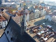
Information about copyright | |
|---|---|
Rights owner | |
Rights characteristic / license | by-sa: CREATIVE COMMONS Attribution-ShareAlike |
Link to the description of the license | |
Image taken over from | commons.wikimedia.org/wiki/File:Vánoční_Plzeň,_katedrála_sv._Bartoloměje_,_pohled_z_věže_01.jpg |
Image has been uploaded | by biroto-Redaktion on 27 Nov 2012
|
Information about copyright | |
|---|---|
Rights owner | |
Rights characteristic / license | by-sa: CREATIVE COMMONS Attribution-ShareAlike |
Link to the description of the license | |
Image taken over from | |
Image has been uploaded | by biroto-Redaktion on 27 Nov 2012
|
Information about copyright | |
|---|---|
Rights owner | |
Rights characteristic / license | by-sa: CREATIVE COMMONS Attribution-ShareAlike |
Link to the description of the license | |
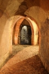
Image taken over from | commons.wikimedia.org/wiki/File:Plzeňské_historické_podzemí_-_chodba.jpg |
Image has been uploaded | by biroto-Redaktion on 27 Nov 2012
|
Information about copyright | |
|---|---|
Rights owner | |
Rights characteristic / license | by-sa: CREATIVE COMMONS Attribution-ShareAlike |
Link to the description of the license | |
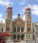
Image taken over from | commons.wikimedia.org/wiki/File:Great_Synagogue_Plzen_CZ.jpg |
Image has been uploaded | by biroto-Redaktion on 27 Nov 2012
|
Pilsen (Czech: Plzeň) is in Bohemia, in the Czech Republic in Central Europe. It is the home and birthplace of the Pilsener (or pilsner) beer variety which is derived from the city's name.
It is the 4th largest city in the country and the largest city in West Bohemia, and is a convenient base for exploring this region of the Czech Republic.
See
Sights
- ⊙St. Bartholomew's Cathedral - the Gothic St. Bartholomew's Cathedral was founded in the late 13th century. Its tower (102.26 m/335 ft) is the highest in the Czech Republic. Official website.
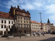
- ⊙ The Town Hall - this Renaissance masterpiece was built in 1554-1559, based on the designs of an Italian architect, Giovanni de Statia.
- Historical underground network - a sophisticated system of cellars and tunnels of up to three levels under the whole Old Town area. It is accessible from the Brewery Museum in Veleslavínova street. Official website.
- ⊙ The Great Synagogue - the second largest synagogue in Europe and third largest in the world (after synagogues in Jerusalem and Budapest).
- ⊙Pilsner Urquell Brewery, U Prazdroje 7, ☎ +420 377 062888. Daily from 12:30PM. Founded in 1842, home to the Pilsner Urquell, the original Pilsener. Tour: 150 Kč. .
Museums
- ⊙West Bohemian Museum (Kopeckeho sady 2) - regular exhibitions
- ⊙Ethnography Museum of the Pilsen Region (nam. Republiky 13) - regular exhibitions
- ⊙Brewery Museum (Veleslavinova 6) - history of brewing in Pilsen
- Techmania Science Center (Borská street) - Modern interactive museum on the premises of the Škoda factory.
- ⊙Patton Memorial Pilsen (sady Pětatřicátníků) - The only American Army museum in Bohemia, opened on the occasion of the 60th anniversary of the liberation of Pilsen and South-West Bohemia. It features the stay of the American soldiers in the region May through November 1945.
- ⊙Ghost Museum (nám. Republiky 33) - The exhibition features the themes of fairy-tale worlds and legends. Recommended especially for children.
- ⊙Puppet Museum (nám. Republiky 24) - Located in the completely adapted historical house No. 24 in the Square of the Republic, the Puppet Museum was expected to be opened in 2009. Exhibitions and workshops will map the unique history and present of Pilsen puppetry and offer interactive activities for both children and adult visitors.
- Pilsen Municipal Armoury (Kopeckého sady 2) - it ranks among the best preserved armouries of the European medieval towns. It began in 1363 when the Emperor Charles IV was building armouries in a planned manner in the royal Czech towns to provide for their readiness. The oldest part includes a set of firearms from the turn of the 14th century. An extensive set of battlement guns with simple fuse systems was created in the first half of the 16th century. The firearms collection is completed historically by muskets from the Thirty-Year War period. Cold weapons are represented in the armoury by morgenstern from the 15th century and arquebuses from the 16th and 17th centuries. The armours of Plzeň burghers are represented by a great number of chest and back plates, shoulder and arm protecting plates, and many helmets of different types.
- ⊙Diocese Museum (Františkánská street) - Exposition of Gothic, Renaissance and Baroque sculptures in the cloister of the Franciscan monastery, chapel of St. Barbara with Gothic frescos, exhibition hall in the Baroque monastic refectory. Museum temporarily closed.
Galleries
- ⊙Pilsen City Art Gallery (Dominikánská 2)
- ⊙West Bohemian Art Gallery "Masné krámy" (Pražská 18)
- Jiří Trnka Art Gallery (nám. Republiky 40)
Eat
- ⊙Na Spilce, U Prazdroje 7, ☎ +420 377 062755. M-Th, Sat 11AM-10PM. F 11AM-11PM. Sun 11AM-9PM. The biggest restaurant in the Czech Republic with 550 seats. Within the grounds of the Prazdroj brewery
- Plzeňská bašta (Riegrova 5) - a stylish Czech restaurant, good meals
- ⊙U Salzmannů (Pražská 8) - the oldest beer restaurant in Pilsen serving Czech traditional cuisine
- Jadran (Bezručova 9) - both Czech and international (especially Mediterranean) cuisine
- ⊙Stará sladovna (Malá 3) - Middle-Age-style restaurant
- ⊙Na Parkane (Veleslavinova 4) - the pub to get truly excellent unfiltered Urquell
- U Pašáka (Poděbradova 12) - microbrewery with home-brewed beer and good Czech cuisine
Information about copyright | |
|---|---|
Rights characteristic / license | by-sa: CREATIVE COMMONS Attribution-ShareAlike |
Link to the description of the license | |
Input taken over from: |
Wikivoyage contributors, 'Pilsen', Wikivoyage, The FREE worldwide travel guide that anyone can edit, 5 June 2016, 00:47 UTC, <https://en.wikivoyage.org/w/index.php?title=Pilsen&oldid=3006372> [accessed 12 October 2016] |
taken over / edited on | 12 Oct 2016
|
taken over / edited by |
|
![]()