
Cycle Route Jels-Toender
No. of cycle route 9
Actions
![]()
Please wait - map data are loading
Added on 06 Jul 2013,
last edited by Ottocolor on 08 Jul 2013
Actions
Cycle route metrics
Total distance in km
68
Information about rights to the gps-track data | |
|---|---|
Rights owner | OpenStreetMap and Contributors + biroto-Redaktion (biroto.eu) |
Rights characteristic / license | Contains information from OpenStreetMap, which is made available here under the Open Database License(ODbL) |
Link to the description of the license | |
GPX file taken from | |
GPX file uploaded | by biroto-Redaktion on 24 Oct 2023
|
Track points in total
720
Track points per km (avg)
11
Start/endpoint
Start location
Sommersted, 83, DK (32 m NHN)
End location
Tønder, 83, DK (4 m NHN)
Character
Information about copyright | |
|---|---|
Rights characteristic / license | by-sa: CREATIVE COMMONS Attribution-ShareAlike |
Link to the description of the license | |
taken over / edited on | 06 Jul 2013
|
taken over / edited by |
|
Connecting cycle path
South of Jels: National cycle route 3 ("Hærvejen").
North of Gram: Regional cycle route 4, Southern Jutland (Gram-Ribe).
West of Arrild: Regional cycle route 6, Southern Jutland (Rømø-Hellevad).
In Tønder: National cycle route 8 "Southern sea route" (Rudbøl-Møn's cliff), regional cycle route 12, Southern Jutland (Tønder-Aabenraa), International cycle route "Border route" (GR) (Margrethe polder-Kruså)
Beds4Cyclists, worth visiting and infrastructure
Name and address
Latitude / Longitude
Phone
Fax
Mobile
Type of accommodation
Rating for cyclists
Route km
Dist. to route
Elevation
13 km
0,1 km
28 m
Hours of opening
01/01/2014 - 01/01/2015 Monday, Wednesday 10:00 to 5:00 p.m.
01/01/2014 - 01/01/2015 Friday 10:00 a.m. to 2:00 p.m.
65 km
0,2 km
6 m
66 km
4,3 km
8 m
Information about copyright | |
|---|---|
Rights owner | Malene |
Rights characteristic / license | by-sa: CREATIVE COMMONS Attribution-ShareAlike |
Link to the description of the license | |
Image taken over from | |
Image has been uploaded | by Ottocolor on 12 Jul 2013
|
Information about copyright | |
|---|---|
Rights owner | Wolfgang Sauber |
Rights characteristic / license | by-sa: CREATIVE COMMONS Attribution-ShareAlike |
Link to the description of the license | |
Image taken over from | |
Image has been uploaded | by Ottocolor on 12 Jul 2013
|
Information about copyright | |
|---|---|
Rights owner | Wolfgang Sauber |
Rights characteristic / license | by-sa: CREATIVE COMMONS Attribution-ShareAlike |
Link to the description of the license | |
Image taken over from | |
Image has been uploaded | by Ottocolor on 12 Jul 2013
|
Information about copyright | |
|---|---|
Rights owner | Jørgen Larsen/ ultraman/ ultramandk |
Rights characteristic / license | by-sa: CREATIVE COMMONS Attribution-ShareAlike |
Link to the description of the license | |
Image taken over from | Jørgen Larsen/ ultraman/ ultramandk Licens |
Image has been uploaded | by Ottocolor on 12 Jul 2013
|
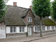
Møgeltønder (Danish pronunciation: [ˈmøːˀl̩tˢønˀɐ]) is a small town with a population of 880 (1 January 2013), located in Møgeltønder Parish and Tønder Municipality in the southwestern corner of the Danish peninsula of Jutland ![]() 5 kilometers north of the Danish-German border and 4 kilometer west of Tønder
5 kilometers north of the Danish-German border and 4 kilometer west of Tønder ![]() .
.
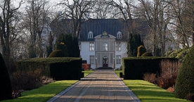
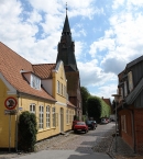
Møgeltønder is known for the royal residence of Schackenborg Castle ![]() the home of the Danish Queen Margrethe II and Prince Henrik's younger son Prince Joachim.
the home of the Danish Queen Margrethe II and Prince Henrik's younger son Prince Joachim.
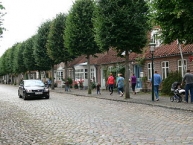
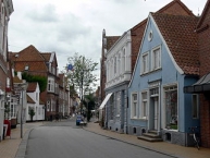
Møgeltønder is also known for the main street "Slotsgaden" (The Castle Street) covered with paving-stones and flanked with lime trees.
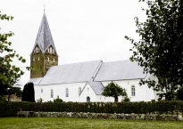
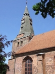
Møgeltønder Church is one of the largest village churches in the southern Jutland and has a rich interior e.g. a painting of the Golden Horns of Gallehus ![]() discovered at Gallehus just north of the town.
discovered at Gallehus just north of the town.
Information about copyright | |
|---|---|
Rights characteristic / license | by-sa: CREATIVE COMMONS Attribution-ShareAlike |
Link to the description of the license | |
Input taken over from: |
Møgeltønder. (2013, June 6). In Wikipedia, The Free Encyclopedia. Retrieved 14:25, July 12, 2013, fromhttp://en.wikipedia.org/w/index.php?title=M%C3%B8gelt%C3%B8nder&oldid=558613586 |
taken over / edited on | 12 Jul 2013
|
taken over / edited by |
|
66 km
0,3 km
7 m
66 km
0,0 km
5 m
Information about copyright | |
|---|---|
Rights owner | Clemensfranz |
Rights characteristic / license | by-sa: CREATIVE COMMONS Attribution-ShareAlike |
Link to the description of the license | |
Image taken over from | |
Image has been uploaded | by Ottocolor on 12 Jul 2013
|
Information about copyright | |
|---|---|
Rights owner | Wolfgang Sauber |
Rights characteristic / license | by-sa: CREATIVE COMMONS Attribution-ShareAlike |
Link to the description of the license | |
Image taken over from | |
Image has been uploaded | by Ottocolor on 12 Jul 2013
|
Information about copyright | |
|---|---|
Rights owner | Jürgen Howaldt |
Rights characteristic / license | by-sa: CREATIVE COMMONS Attribution-ShareAlike |
Link to the description of the license | |
Image taken over from | |
Image has been uploaded | by Ottocolor on 12 Jul 2013
|
Information about copyright | |
|---|---|
Rights owner | Achim Strehlke |
Rights characteristic / license | by-sa: CREATIVE COMMONS Attribution-ShareAlike |
Link to the description of the license | |
Image taken over from | |
Image has been uploaded | by Ottocolor on 12 Jul 2013
|
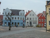
Tønder (German: Tondern) is a Danish town in the Region of Southern Denmark with a population of 7,572 (1 January 2013). It is the main town and the administrative seat of Tønder Municipality.
During World War I, a base for Zeppelin ![]() airships was operated at Tønder by the German Navy
airships was operated at Tønder by the German Navy ![]() . The former site now houses a museum, the Zeppelin and Garrison Museum Tønder. The base was attacked by the British on 19 July 1918, during what is known as theTondern raid
. The former site now houses a museum, the Zeppelin and Garrison Museum Tønder. The base was attacked by the British on 19 July 1918, during what is known as theTondern raid ![]() . Seven Sopwith Camels
. Seven Sopwith Camels ![]() from the aircraft carrier HMS Furious
from the aircraft carrier HMS Furious ![]() bombed the base and two of the three Airship hangars
bombed the base and two of the three Airship hangars ![]() were hit, the Zeppelins L.54 and L.60 inside one hanger were destroyed and a balloon inside the other was damaged. After this, Tondern was abandoned as an active airship base, and ordered to be used only as an emergency landing site. A wartime aircraft hangar survives, as do some of the ancillary buildings from the period, but only the foundations remain of the large airship hangars.
were hit, the Zeppelins L.54 and L.60 inside one hanger were destroyed and a balloon inside the other was damaged. After this, Tondern was abandoned as an active airship base, and ordered to be used only as an emergency landing site. A wartime aircraft hangar survives, as do some of the ancillary buildings from the period, but only the foundations remain of the large airship hangars.
After the First World War, Tønder was detached from Germany even though 77% of the voters had voted to remain with the German Empire in the Schleswig Plebiscites ![]() . In the following years German political parties had a majority in the city council. Until 1945, the city was officially bilingual. During World War II, Tønder was the place where the German forces crossed the border to occupy Denmark. Later, Tønder came to host a small, German concentration camp (see Tønder concentration camp). Shortly after the re-establishment of the Danish administration Tønder was the site of a garrison.
. In the following years German political parties had a majority in the city council. Until 1945, the city was officially bilingual. During World War II, Tønder was the place where the German forces crossed the border to occupy Denmark. Later, Tønder came to host a small, German concentration camp (see Tønder concentration camp). Shortly after the re-establishment of the Danish administration Tønder was the site of a garrison.
After the end of the German occupation in World War II, the political significance of the German part of the population dwindled considerably. The border situation hindered the development of the city. Nevertheless, some companies settled. The importance of tourism increased. Despite the improvement of cross-border traffic, the location was in the late 20th Tønders Century increasingly difficult. In 1989, a teacher training college opened its doors in 2002, the barracks and in the following year the hospital, which is, however, now been enhanced as a private clinic again.
Attractions
Every August, the Tønder Festival ![]() offers visitors a wide variety of traditional and modern folk music. The Scouts of Tonder are twinned with Hemyock
offers visitors a wide variety of traditional and modern folk music. The Scouts of Tonder are twinned with Hemyock ![]() , in Devon, England, and the scouts make exchange trips every few years.
, in Devon, England, and the scouts make exchange trips every few years.
Information about copyright | |
|---|---|
Rights characteristic / license | by-sa: CREATIVE COMMONS Attribution-ShareAlike |
Link to the description of the license | |
Input taken over from: |
Tønder. (2013, June 28). In Wikipedia, The Free Encyclopedia. Retrieved 13:52, July 12, 2013, fromhttp://en.wikipedia.org/w/index.php?title=T%C3%B8nder&oldid=561974030 |
taken over / edited on | 12 Jul 2013
|
taken over / edited by |
|