
2-Countries-Cycle Route
Actions
![]()
Please wait - map data are loading
Added on 01 Apr 2012,
last edited by biroto-Redaktion on 14 Apr 2024
Actions
Cycle route metrics
Total distance in km
283
Information about rights to the gps-track data | |
|---|---|
Rights owner | OpenStreetMap and Contributors + biroto-Redaktion (biroto.eu) |
Rights characteristic / license | Contains information from OpenStreetMap, which is made available here under the Open Database License(ODbL) |
Link to the description of the license | |
GPX file taken from | |
GPX file uploaded | by biroto-Redaktion on 14 Apr 2024
|
Track points in total
4.362
Track points per km (avg)
15
Start/endpoint
Start location
Nijmegen, Gelderland, NL (11 m NHN)
End location
Aachen, Nordrhein-Westfalen, DE (187 m NHN)
Character
Die 2-Länder-Route (2LR) ist ein ca. 280 km langer Radfernweg in Nordrhein-Westfalen und den Niederlanden. Sie führt von der Kaiserstadt Aachen ![]() bis nach Nimwegen
bis nach Nimwegen ![]() und wechselt dabei mehrfach über die deutsch-niederländische Grenze.
und wechselt dabei mehrfach über die deutsch-niederländische Grenze.
Die 2-Länder-Route folgt über weite Strecken dem Verlauf von Maas und Wurm ![]() . Größere Steigungen sind nur auf dem Streckenabschnitt in und um Aachen
. Größere Steigungen sind nur auf dem Streckenabschnitt in und um Aachen ![]() zu überwinden, bis sich die Route durch typisch niederrheinische Landschaft zwischen Rhein und Maas in meist ebenem Gebiet fortsetzt. Somit ist die 2-Länder-Route sowohl landschaftlich als auch kulturell interessant, insbesondere da sie zu rund 350 historischen Sehenswürdigkeiten der deutsch-niederländischen Geschichte führt.
zu überwinden, bis sich die Route durch typisch niederrheinische Landschaft zwischen Rhein und Maas in meist ebenem Gebiet fortsetzt. Somit ist die 2-Länder-Route sowohl landschaftlich als auch kulturell interessant, insbesondere da sie zu rund 350 historischen Sehenswürdigkeiten der deutsch-niederländischen Geschichte führt.
Information about copyright | |
|---|---|
Rights characteristic / license | by-sa: CREATIVE COMMONS Attribution-ShareAlike |
Link to the description of the license | |
Input taken over from: |
Seite „2-Länder-Route“. In: Wikipedia, Die freie Enzyklopädie. Bearbeitungsstand: 24. Juni 2012, 00:52 UTC. URL: http://de.wikipedia.org/w/index.php?title=2-L%C3%A4nder-Route&oldid=104734544 |
taken over / edited on | 04 Apr 2013 - 14 Apr 2024
|
taken over / edited by |
|
Signposting
|

Beds4Cyclists, worth visiting and infrastructure
Name and address
Latitude / Longitude
Phone
Fax
Mobile
Type of accommodation
Rating for cyclists
Route km
Dist. to route
Elevation
0 km
1,2 km
26 m
0 km
0,5 km
33 m
0 km
1,3 km
38 m
0 km
0,9 km
24 m
Information about copyright | |
|---|---|
Rights owner | https://web.archive.org/web/20161022014754/www.panoramio.com/user/1268212?with_photo_id=66337 |
Rights characteristic / license | by-sa: CREATIVE COMMONS Attribution-ShareAlike |
Link to the description of the license | |
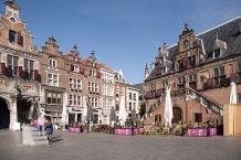
Image taken over from | https://commons.wikimedia.org/wiki/File:Grote_Markt,_Nijmegen_-_panoramio.jpg |
Image has been uploaded | by biroto-Redaktion on 11 Jun 2022
|
Nijmegen lays claims to the title of oldest city in the Netherlands , and has indeed a long history and still lots of interesting heritage to enjoy today. World-famous among hiking enthusiast, the city annually hosts the International Four Days Marches Nijmegen. It's the largest multi-day walking event in the world and comes with a range of festivities. Attracting over 42,000 participants and over a million visitors, including many international ones, the event celebrated the 100th edition in 2016. Nijmegen is the largest city in the province of Gelderland and well known for its left-wing politics and its large student population.
Understand
With about 160,000 inhabitants, Nijmegen is a relatively large city in the southeast of the Netherlands. It's the main town in the Arnhem -Nijmegen metropolitan area (pop. 736,000 in 2011) and a major stronghold of the Dutch socialist and 'green' parties.
The town's written history goes back to the first century BC, when a Roman military settlement was established at this place. The local hill provide good views over the surrounding valleys and the rivers Rhine and Waal that pass by here. A village grew around the Roman stronghold. In the year 98 it gained Roman city rights. After the Roman Empire crumbled, the area became part of the Frankish lands. The town grew as its trade activities via the river Waal flourished.
In the 12th century, Henry VI, the later Holy Roman Emperor was born in Nijmegen but it was his son, Holy Roman Emperor Frederick II, who granted city rights in 1230. Some 17 years later, the city and the surrounding lands were used as collateral for a loan from the Guelders, that would never be repaid. As a result, Nijmegen is part of the province of Gelderland still today.
As modern warfare rendered traditional fortifications as good as useless, the city walls were finally demolished. The city had already expanded massively by that time, with far too many souls living packed inside the city walls. And it kept developing further. A university was established in 1927 and in 1936 the reportedly largest bridge in Europe of that time was constructed for car passage over the river.
In 1944, the city centre sustained massive damage when it was bombed by the Americans by mistake, as pilots thought they were attacking the German city of Kleve . Shortly after, it was the scene of severe battle during Operation Market Garden. When the city was finally liberated, most of its historic heritage was gone or damaged. Rebuilding efforts and city planning in the following decades included further destruction of some of the remaining structures. The fine collection of monuments today is therefore only a small glimpse of Nijmegen's rich history.
See
Nijmegen is widely considered to be the oldest city in the Netherlands, celebrating her 2000th birthday in 2005. Not a whole lot of very old buildings are left in town: first the Americans carpet-bombed it in February 1944, later the Germans shelled it for about 5 months after the liberation in September 1944, and finally there were a lot of very rigorous city planners in the 1950s, 60s and 70s who finished what the Americans and Germans started.
There are still a few noteworthy sights, however. Valkhof hill downtown features a Carolingian chapel (eight, ninth century AD) and a small remainder of an imperial castle that was demolished in 1798. From Valkhof hill walk west through the Burchtstraat. Here you will see, on your left hand, the fifteenth century town hall. If you've finished admiring its exterior (there's nothing of note inside) continue walking west to the Grote Markt (Great Market) on the north side is a sixteenth-century weighing hall that now serves as a restaurant. To the left is the Blauwe Hand, the oldest bar in a town that boasts the most pubs per square feet than any other town in the Netherlands. On the west side you will see the entrance to the St. Stevenskerk courtyard. Enter it. On the left is a fifteenth-century Latin school. On the right stands the thirteenth century St. Stevenskerk, the interior of which was destroyed during the Dutch revolution of the sixteenth century. To the north of the church is a series of small seventeenth-century houses that now serve as trinket shops.
Although the city centre was heavily bombed during the war, the old neighbourhoods around the centre were not, and are nice to stroll around. Most interesting are the neighbourhoods east and south of the centre. Bottendaal, a five-minute walk from the train station, has a nice vibe, a few good pubs (try De Kluizenaar and Maxim, listed below) and a park (Thiemen Park).
- ⊙Valkhof Museum, Kelfkensbos 59 (On the edge of the Valkhof park), ☎ +31 243 608805. The fine collection of archaeological finds, modern and some old art is well worth spending a few hours on. Artefacts go back to prehistoric times, but also include Roman and Medieval pieces. In addition to the permanent displays, there are temporary exhibitions focussing on specific artists or crafts. Adult €8, child €4.

- ⊙St. Stevenskerk, Sint Stevenskerkhof 62, ☎ +31 243 604710.The construction of the church began around the middle of the 13th century. In 1273 the church was consecrated by Albertus Magnus, the auxiliary bishop of Cologne. Of this Romanesque-Gothic church remain the base of the tower and the westernmost bays of the ship. Large-scale construction took place over the course of the 15th century, including the choir and chapels. In the 16th century, was built in the transept and a small part of the ship. After about 1560 halted construction, which the church remained unfinished. The tower was in the 15th century, a new floor clocks. In the bombing of February 22, 1944 the tower collapsed largely in. In addition, the south- western part of the church was heavily damaged. The church also was badly damaged when Nijmegen was a city at the war front. After World War II the church was thoroughly restored in 1969 and was re-opened in the presence of HRH Prince Claus. The inventory of the church - namely pulpit monument to Catherine of Bourbon, baptistery-screen, gentlemen banks, candelabra, organs and some frescoes - are from the 16th, 17th and 18th centuries. Free.
- ⊙Nationaal Fietsmuseum Velorama (Bicycle museem), Waalkade 107 (Close to Walkhof Park), ☎ +31 243 225851. M-Sa 10:00 - 17:00, Su 11:00 - 17:00. The Velorama is a bicycle museum in the Netherlands €5.
- ⊙Aunt Hannie Movie and TV series museum (Tante Hannie Kijk Doe Koopwinkel), Passage Molenpoort 33a (in De Molenpoort shopping center; entrance at stairs between Pipoos and Kramer Beds), ☎ +31 63 3049119. W noon-17:30, Th 10:00-20:00, F 10:00-17:30, Sa 10:00-17:00, Su noon-17:00. Minions, Muppets, Marvel, and Marbles..oh my! A gift shop and museum for all kinds of pop media franchises. Browsing around will cast you back to your childhood. Lots of big-name franchises are represented here, along with independents like the popular YouTube channel Jelle's Marble Runs (the creator of which lives in Nijmegen). Gift shop free; marble museum €2.
Eat
Being a student town (roughly 21,000 students in a population of 160,000) there are plenty of relatively cheap restaurants ("eetcafés") to be found. Look for them in the Van Welderenstraat and on Kelfkensbos. Fast Food is also widely available in the city center, with two McDonald's, a Burger King and numerous snackbars often offering traditional Dutch snacks, but also Turkish dishes.
Information about copyright | |
|---|---|
Rights characteristic / license | by-sa: CREATIVE COMMONS Attribution-ShareAlike |
Link to the description of the license | |
Input taken over from: |
Wikivoyage contributors, 'Nijmegen', Wikivoyage, The FREE worldwide travel guide that anyone can edit, 30 January 2022, 01:00 UTC, https://en.wikivoyage.org/w/index.php?title=Nijmegen&oldid=4379952 |
taken over / edited on | 07 Jun 2022
|
taken over / edited by |
|
0 km
0,9 km
26 m
Hours of opening
Mi-So 10:00-17:00
![]()