
Cycle Route Lake Constance Route
Actions
![]()
Please wait - map data are loading
Added on 06 Mar 2013,
last edited by biroto-Redaktion on 26 Jan 2024
Actions
Cycle route metrics
Total distance in km
278
Information about rights to the gps-track data | |
|---|---|
Rights owner | OpenStreetMap and Contributors + biroto-Redaktion (biroto.eu) |
Rights characteristic / license | Contains information from OpenStreetMap, which is made available here under the Open Database License(ODbL) |
Link to the description of the license | |
GPX file taken from | |
GPX file uploaded | by biroto-Redaktion on 26 Jan 2024
|
Track points in total
4.949
Track points per km (avg)
18
Start/endpoint
Start location
Stein am Rhein, Schaffhausen, CH (413 m NHN)
End location
Langwiesen, Zürich, CH (406 m NHN)
Signposting
in Deutschland |
|

Travel reports about cycle tours
Information about copyright | |
|---|---|
Rights owner | |
Rights characteristic / license | © all rights reserved. |
Image has been uploaded | by biroto-Redaktion on 04 Nov 2011
|
06 Aug 2011
107 km
A stage of the tour »Lake Constance - Rhine Valley - Solingen« of user ThimbleU
Information about copyright | |
|---|---|
Rights owner | |
Rights characteristic / license | © all rights reserved. |
Image has been uploaded | by Tandemteam-Traudel_und_Dieter on 14 Mar 2017
|
28 Jul 2011
63 km
A stage of the tour »Hospental nach Basel« of user Tandemteam-Traudel_und_Dieter
Information about copyright | |
|---|---|
Rights owner | |
Rights characteristic / license | © all rights reserved. |
Image has been uploaded | by Tandemteam-Traudel_und_Dieter on 13 Mar 2017
|
27 Jul 2011
71 km
A stage of the tour »Hospental nach Basel« of user Tandemteam-Traudel_und_Dieter
Beds4Cyclists, worth visiting and infrastructure
Name and address
Latitude / Longitude
Phone
Fax
Mobile
Type of accommodation
Rating for cyclists
Route km
Dist. to route
Elevation
1 km
0,2 km
415 m
2 km
0,2 km
414 m
5 km
0,1 km
411 m
Information about copyright | |
|---|---|
Rights owner | |
Rights characteristic / license | by-sa: CREATIVE COMMONS Attribution-ShareAlike |
Link to the description of the license | |
Image taken over from | |
Image has been uploaded | by biroto-Redaktion on 30 Apr 2013
|
Information about copyright | |
|---|---|
Rights owner | |
Rights characteristic / license | by-sa: CREATIVE COMMONS Attribution-ShareAlike |
Link to the description of the license | |
Image taken over from | |
Image has been uploaded | by biroto-Redaktion on 30 Apr 2013
|
Information about copyright | |
|---|---|
Rights owner | |
Rights characteristic / license | cc0: Public Domain no Rights reserved |
Link to the description of the license | |
Image taken over from | |
Image has been uploaded | by biroto-Redaktion on 30 Apr 2013
|
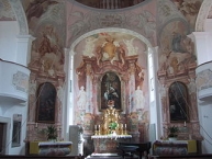
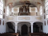
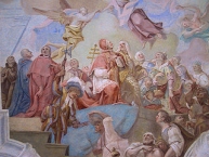
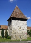
Die Schlosskapelle Mammern ist ein barocker Sakralbau innerhalb des ehemaligen Schlosses Mammern ![]() am thurgauischen
am thurgauischen ![]() Ufer des Untersees
Ufer des Untersees ![]() .
.
Sie kann als Zeugnis des Höhepunktes der Gegenreformation ![]() in Mammern bezeichnet werden. Angeregt haben ihren Bau der Statthalter des Klosters Rheinau
in Mammern bezeichnet werden. Angeregt haben ihren Bau der Statthalter des Klosters Rheinau ![]() in Mammern, Roman Effinger und der damalige Abt des Klosters Bernhard II. Rusconi, der am 11. Mai 1749 die Grundsteinlegung vornahm. Bereits im Dezember konnte die Kapelle provisorisch eingeweiht werden. Die feierliche Weihe fand am 14. Juli 1750 statt. Die Kapelle steht ganz im Zeichen der Marienverehrung
in Mammern, Roman Effinger und der damalige Abt des Klosters Bernhard II. Rusconi, der am 11. Mai 1749 die Grundsteinlegung vornahm. Bereits im Dezember konnte die Kapelle provisorisch eingeweiht werden. Die feierliche Weihe fand am 14. Juli 1750 statt. Die Kapelle steht ganz im Zeichen der Marienverehrung ![]() .
.
Information about copyright | |
|---|---|
Rights characteristic / license | by-sa: CREATIVE COMMONS Attribution-ShareAlike |
Link to the description of the license | |
Input taken over from: |
Seite „Schlosskapelle Mammern“. In: Wikipedia, Die freie Enzyklopädie. Bearbeitungsstand: 3. November 2012, 17:26 UTC. URL: http://de.wikipedia.org/w/index.php?title=Schlosskapelle_Mammern&oldid=110072858 (Abgerufen: 30. April 2013, 08:52 UTC) |
taken over / edited on | 30 Apr 2013
|
taken over / edited by |
|
9 km
0,0 km
416 m
11 km
0,1 km
404 m
Information about copyright | |
|---|---|
Rights owner | |
Rights characteristic / license | by-sa: CREATIVE COMMONS Attribution-ShareAlike |
Link to the description of the license | |
Image taken over from | commons.wikimedia.org/wiki/File:Steckborn-Rathaus-Seeseite.jpg |
Image has been uploaded | by biroto-Redaktion on 22 Apr 2013
|
Information about copyright | |
|---|---|
Rights owner | |
Rights characteristic / license | by-sa: CREATIVE COMMONS Attribution-ShareAlike |
Link to the description of the license | |
Image taken over from | commons.wikimedia.org/wiki/File:Steckborn-Turmhof-Seeseite.jpg |
Image has been uploaded | by biroto-Redaktion on 22 Apr 2013
|
Information about copyright | |
|---|---|
Rights owner | |
Rights characteristic / license | by-sa: CREATIVE COMMONS Attribution-ShareAlike |
Link to the description of the license | |
Image taken over from | |
Image has been uploaded | by biroto-Redaktion on 22 Apr 2013
|
Information about copyright | |
|---|---|
Rights owner | |
Rights characteristic / license | by-sa: CREATIVE COMMONS Attribution-ShareAlike |
Link to the description of the license | |
Image taken over from | |
Image has been uploaded | by biroto-Redaktion on 22 Apr 2013
|
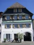
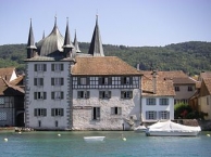
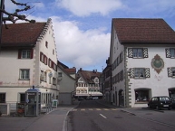
Steckborn ist eine politische Gemeinde des Bezirks Frauenfeld des Kantons Thurgau in der Schweiz.
Das kleine Städtchen wurde befestigt. Teile der Stadtmauer sind heute noch erhalten. Das geschlossene Ortsbild wurde vorwiegend aufgrund einer geplanten Überbauung erreicht. Einige wichtige alte Bauten stehen unter Bundesschutz, Steckborn ist im Bundesinventar der wertvollen Ortsbilder enthalten.
Information about copyright | |
|---|---|
Rights characteristic / license | by-sa: CREATIVE COMMONS Attribution-ShareAlike |
Link to the description of the license | |
Input taken over from: |
Seite „Steckborn“. In: Wikipedia, Die freie Enzyklopädie. Bearbeitungsstand: 31. März 2013, 17:30 UTC. URL: http://de.wikipedia.org/w/index.php?title=Steckborn&oldid=116386461 (Abgerufen: 22. April 2013, 21:22 UTC) |
taken over / edited on | 22 Apr 2013
|
taken over / edited by |
|
![]()