
Cycle Route Mikkeli - Imatra
No. of cycle route 14
Actions
![]()
Please wait - map data are loading
Added on 27 Dec 2011,
last edited by biroto-Redaktion on 04 Dec 2020
Actions
Cycle route metrics
Total distance in km
297
Information about rights to the gps-track data | |
|---|---|
Rights owner | OpenStreetMap and Contributors + biroto-Redaktion (biroto.eu) |
Rights characteristic / license | Contains information from OpenStreetMap, which is made available here under the Open Database License(ODbL) |
Link to the description of the license | |
GPX file taken from | |
GPX file uploaded | by biroto-Redaktion on 04 Dec 2020
|
Track points in total
4.057
Track points per km (avg)
14
Start/endpoint
Start location
Mikkeli, Eastern Finland, FI (89 m NHN)
End location
Imatra, Southern Finland, FI (107 m NHN)
Beds4Cyclists, worth visiting and infrastructure
Name and address
Latitude / Longitude
Phone
Fax
Mobile
Type of accommodation
Rating for cyclists
Route km
Dist. to route
Elevation
170 km
0,2 km
89 m
Information about copyright | |
|---|---|
Rights owner | |
Rights characteristic / license | by-sa: CREATIVE COMMONS Attribution-ShareAlike |
Link to the description of the license | |
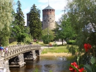
Image taken over from | https://commons.wikimedia.org/wiki/File:Savonlinna_heinäkuu_2002_IMG_1635.JPG |
Image has been uploaded | by biroto-Redaktion on 04 Dec 2020
|
Information about copyright | |
|---|---|
Rights owner | |
Rights characteristic / license | by-sa: CREATIVE COMMONS Attribution-ShareAlike |
Link to the description of the license | |
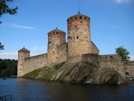
Image taken over from | https://commons.wikimedia.org/wiki/File:Olavinlinna_2016_2.jpg |
Image has been uploaded | by biroto-Redaktion on 04 Dec 2020
|
Information about copyright | |
|---|---|
Rights owner | |
Rights characteristic / license | by: CREATIVE COMMONS Attribution |
Link to the description of the license | |
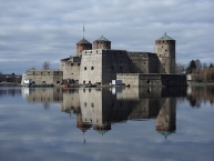
Image taken over from | https://commons.wikimedia.org/wiki/File:Olavinlinna_in_Savonlinna.jpg |
Image has been uploaded | by biroto-Redaktion on 04 Dec 2020
|
Olavinlinna (Swedish: Olofsborg; literally Olaf's Castle) is a 15th-century three-tower castle located in Savonlinna ![]() , Finland. It is built on an island in the Kyrönsalmi strait that connects the lakes Haukivesi
, Finland. It is built on an island in the Kyrönsalmi strait that connects the lakes Haukivesi ![]() and Pihlajavesi
and Pihlajavesi ![]() . It is the northernmost medieval stone fortress still standing.
. It is the northernmost medieval stone fortress still standing.
The castle forms a spectacular stage for the Savonlinna Opera Festival ![]() , held annually in the summer since 1912.
, held annually in the summer since 1912.
History
The fortress was founded by Erik Axelsson Tott in 1475 under the name Sankt Olofsborg in an effort to profit from the political turmoil following Ivan III's conquest of the Novgorod Republic. It was sited in Savonia ![]() so as to lay claim to the Russian side of the border established by the Treaty of Nöteborg.
so as to lay claim to the Russian side of the border established by the Treaty of Nöteborg.
One of Tott's letters from 1477 includes a passing mention of foreign builders invited to Olofsborg, probably from Reval ![]() , where the city fortifications were being extended. It was the first Swedish castle provided with a set of thickset circular towers that could withstand cannon fire. It is not by accident that a network of lakes and waterways forms the setting for the castle, for these would seriously impede a prospective Russian offensive.
, where the city fortifications were being extended. It was the first Swedish castle provided with a set of thickset circular towers that could withstand cannon fire. It is not by accident that a network of lakes and waterways forms the setting for the castle, for these would seriously impede a prospective Russian offensive.
The three-towered keep was completed in 1485, and the construction of the outer curtain walls with two towers was initiated immediately. They were completed in 1495. The castle is roughly a truncated rhomboid with keep on the western side of the island and the curtain walls and outer bailey to east. One of the towers of the keep, St. Erik's Tower, has a bad foundation and has since collapsed. One of the towers of Bailey, the Thick Tower, exploded in the 18th century. A bastion has been built on its place. The castle was converted into a Vaubanesque fort in the late 18th century with bastions.
Tourism
The castle hosts several small exhibitions, including the Castle Museum which displays artifacts found in the castle or related to it, and the Orthodox Museum which displays icons and other religious artifacts both from Finland and Russia.
Information about copyright | |
|---|---|
Rights characteristic / license | by-sa: CREATIVE COMMONS Attribution-ShareAlike |
Link to the description of the license | |
Input taken over from: |
Wikipedia contributors, 'Olavinlinna', Wikipedia, The Free Encyclopedia, 7 September 2020, 05:26 UTC, https://en.wikipedia.org/w/index.php?title=Olavinlinna&oldid=977147540 [accessed 4 December 2020] |
taken over / edited on | 04 Dec 2020
|
taken over / edited by |
|