Cycle Route Via Fluvia
No. of cycle route V73
Actions

Please wait - map data are loading
Added on 22 Sep 2023,
last edited by biroto-Redaktion on 23 Sep 2023
Actions
Cycle route metrics
Total distance in km
163
Information about rights to the gps-track data | |
|---|---|
Rights owner | OpenStreetMap and Contributors + biroto-Redaktion (biroto.eu) |
Rights characteristic / license | Contains information from OpenStreetMap, which is made available here under the Open Database License(ODbL) |
Link to the description of the license | |
GPX file taken from | |
GPX file uploaded | by biroto-Redaktion on 22 Sep 2023
|
Track points in total
3.151
Track points per km (avg)
19
Start/endpoint
Start location
Landos, ARA, FR (1011 m NHN)
End location
Sarras, ARA, FR (129 m NHN)
Signposting
|
|

Beds4Cyclists, worth visiting and infrastructure
Name and address
Latitude / Longitude
Phone
Fax
Mobile
Type of accommodation
Rating for cyclists
Route km
Dist. to route
Elevation
157 km
2,3 km
136 m
Information about copyright | |
|---|---|
Rights owner | |
Rights characteristic / license | by-sa: CREATIVE COMMONS Attribution-ShareAlike |
Link to the description of the license | |
Image taken over from | |
Image has been uploaded | by biroto-Redaktion on 09 Aug 2012
|
Andance ist eine französische Gemeinde mit 1126 Einwohnern (Stand 1. Januar 2009) in der Region Rhône-Alpes.
Andance ist bekannt für seine historische Altstadt entlang der Rhône mit dem Flair einer Hafenstadt. Der mittelalterliche Schutzwall stammt noch aus der Zeit der Grafen von Albon. Ein steinernes Kreuz auf dem Place du Cloître zeigt die Köpfe der Heiligen, zu deren Ehren drei Kreuze auf dem Aussichtspunkt Châtelet errichtet worden sind. Über dem First des Kreuzes, ist ein Boot eingraviert worden, das von einem Stern geführt wird.
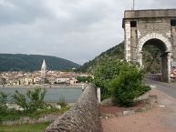
Die Hängebrücke über der Rhône, die Andance mit Andancette verbindet, ist die Älteste in Frankreich, die noch benutzt wird. Sie wurde 1827 vom Architekten Marc Seguin konstruiert und am 30. August bei einem Bombardement im Zweiten Weltkrieg zerstört. Anschließend erfolgte ein Neuaufbau, bei dem die Brücke von einem Schiffsfahrerkreuz aus Eisen geschmückt wurde, das an die Versuche zahlreicher Männer zur damaligen Bändigung der wilden Rhône erinnert.
Die Kirche aus dem 13. Jahrhundert wurde 1295 vom früheren Abt des Klosters Cluny  Bertrand de Colombier gebaut und beherbergt ein Kreuz zu Gedenken an die Besatzung der Marine entlang der Rhône. Die Kapelle Saint-Bosc inmitten von Weinstöcken ist dem Märtyrer Saint-Barral gewidmet, der als bekennender Christ in Antiochia sein Leben ließ.
Ein antikes Relikt ist die römische Ruine La Sarrasinière, ein Siegerdenkmal der Römer im Kampf gegen die Gallier und Allobroger im ersten Jahrhundert. Während der Invasion der Araber im 8. Jahrhundert wurde das Gebäude stark verstümmelt. Heute weiß man, dass es sich bei der Ruine um ein antikes Mausoleum handelt, in dem Urnen reicher römischer Soldaten und Bürger aufbewahrt wurden.
Den besten Blick über das Gemeindegebiet hat man vom 360 Meter hohen Hügel Châtelet, der schon im vierten Jahrhundert ein Heiligtum der Römer war. Später wurde er zu einer frühchristlichen Nekropolis umgebaut. Heute sind davon keine Überreste mehr sichtbar. Nur noch Funde von Grabesinschriften und Fragmente, die im 19. Jahrhundert entdeckt wurden, bestätigen die Existenz christlicher Gräber auf diesem Gebiet. Ein Kreuzweg erinnert nun an eine Epoche, in der Christen verfolgt wurden. Die drei Kreuze stehen für die Heiligen Agathon, Orianée und Pompina, die aus religiösen Gründen getötet worden sind.
Information about copyright | |
|---|---|
Rights characteristic / license | by-sa: CREATIVE COMMONS Attribution-ShareAlike |
Link to the description of the license | |
Input taken over from: |
Seite „Andance“. In: Wikipedia, Die freie Enzyklopädie. Bearbeitungsstand: 15. Juli 2012, 17:15 UTC. URL: http://de.wikipedia.org/w/index.php?title=Andance&oldid=105613365 (Abgerufen: 9. August 2012, 21:58 UTC) |
taken over / edited on | 09 Aug 2012 - 08 Aug 2016
|
taken over / edited by |
|
157 km
2,4 km
136 m
157 km
3,8 km
136 m
160 km
2,1 km
153 m
163 km
0,8 km
125 m
Hours of opening
All year from Monday to Saturday, 9:30 to 12:30 and 14:00 to 17:30