
Cycle Route La Véloire
No. of cycle route V71
Actions
![]()
Please wait - map data are loading
Added on 07 Apr 2019,
last edited by biroto-Redaktion on 22 Sep 2023
Actions
Cycle route metrics
Total distance in km
179
Information about rights to the gps-track data | |
|---|---|
Rights owner | OpenStreetMap and Contributors + biroto-Redaktion (biroto.eu) |
Rights characteristic / license | Contains information from OpenStreetMap, which is made available here under the Open Database License(ODbL) |
Link to the description of the license | |
GPX file taken from | |
GPX file uploaded | by biroto-Redaktion on 22 Sep 2023
|
Track points in total
2.638
Track points per km (avg)
15
Start/endpoint
Start location
Paray-le-Monial, BFC, FR (243 m NHN)
End location
Saint-André-le-Puy, ARA, FR (357 m NHN)
Signposting
|
|

Beds4Cyclists, worth visiting and infrastructure
Name and address
Latitude / Longitude
Phone
Fax
Mobile
Type of accommodation
Rating for cyclists
Route km
Dist. to route
Elevation
0 km
0,3 km
251 m
0 km
0,5 km
238 m
Hours of opening
The tourist office is open all year.
- from Monday to Saturday from 9h to 12h and from 13h30 to 18h.
Easter to mid-October
- on Sundays and public holidays from 10am to 12:30 pm and 2:30 p.m. to 5:30 pm.
In July and August
- from Monday to Saturday from 9h to 19h and
- Sundays and holidays from 10h to 19h.
0 km
0,5 km
236 m
Information about copyright | |
|---|---|
Rights owner | |
Rights characteristic / license | by-sa: CREATIVE COMMONS Attribution-ShareAlike |
Link to the description of the license | |
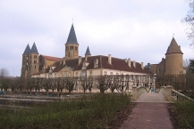
Image taken over from | commons.wikimedia.org/wiki/File:71_-_Paray_le_Monial_Basilique_2.jpg |
Image has been uploaded | by biroto-Redaktion on 11 Mar 2014
|
Information about copyright | |
|---|---|
Rights owner | |
Rights characteristic / license | by-sa: CREATIVE COMMONS Attribution-ShareAlike |
Link to the description of the license | |
Image taken over from | |
Image has been uploaded | by biroto-Redaktion on 11 Mar 2014
|
Information about copyright | |
|---|---|
Rights owner | |
Rights characteristic / license | cc0: Public Domain no Rights reserved |
Link to the description of the license | |
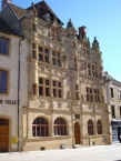
Image taken over from | commons.wikimedia.org/wiki/File:Paray-le-Monial,_hôtel_de_Ville.JPG |
Image has been uploaded | by biroto-Redaktion on 11 Mar 2014
|
Information about copyright | |
|---|---|
Rights owner | |
Rights characteristic / license | by-sa: CREATIVE COMMONS Attribution-ShareAlike |
Link to the description of the license | |
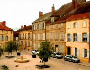
Image taken over from | commons.wikimedia.org/wiki/File:Place_Lamartine-Paray-le-Monial.jpg |
Image has been uploaded | by biroto-Redaktion on 11 Mar 2014
|
Paray-le-Monial ist eine Stadt in Ost-Frankreich, in der Region Burgund im Département Saône-et-Loire. Paray-le-Monial hat 9094 Einwohner (Stand 1. Januar 2011) und erstreckt sich über eine Fläche von ca. 25 km2. Die Stadt liegt am Schifffahrtskanal Canal du Centre ![]() , sowie am parallel verlaufenden Fluss Bourbince
, sowie am parallel verlaufenden Fluss Bourbince ![]() .
.
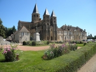
Paray-le-Monial ist vor allen Dingen durch die Prioratskirche Sacré-Cœur ![]() bekannt. Dort ist heute der Sitz der katholischen Bewegung Gemeinschaft Emmanuel.
bekannt. Dort ist heute der Sitz der katholischen Bewegung Gemeinschaft Emmanuel.
Sehenswürdigkeiten
- ⊙ Die Basilika Sacré-Coeur

Das 973 von Graf Lambert von Chalon gegründete Kloster wurde bereits 999 durch den Bischof von Auxerre dem Kloster Cluny unterstellt. In der Folge der Angliederung wurde 1004 die erste Klosterkirche (Paray I) eingeweiht, die aber, trotz der Erweiterung durch den Anbau einer Vorhalle (Paray II) noch vor 1050, bereits zwischen etwa 1090 und 1130 unter Abt Hugo von Cluny durch einen Neubau (Paray III) ersetzt wurde, der noch bis heute erhalten ist. - ⊙Tour Saint-Nicolas aus dem 16. Jahrhundert
- Das ⊙Rathaus aus dem 16. Jahrhundert
Das Hôtel de Ville (Rathaus) im historischen Altstadtkern, das ehemalige Stadthaus des reichen Tuchmachers Jayet, im Stil der frühen Renaissance, mit seiner gelblichen Fassade, ist vor allem durch seine Verzierungen interessant. Muschelornamente und Medaillons mit den Porträts französischer Könige überziehen die gesamte Fassade. - Das ⊙Hiéron-Museum aus dem 19. Jahrhundert (wurde erst vor kurzem renoviert)
- Das Theater aus dem 19. Jahrhundert
- Das ⊙Museum Paul Charnoz (Keramikmuseum)
Information about copyright | |
|---|---|
Rights characteristic / license | by-sa: CREATIVE COMMONS Attribution-ShareAlike |
Link to the description of the license | |
Input taken over from: |
Seite „Paray-le-Monial“. In: Wikipedia, Die freie Enzyklopädie. Bearbeitungsstand: 1. April 2013, 23:10 UTC. URL: http://de.wikipedia.org/w/index.php?title=Paray-le-Monial&oldid=116528416 (Abgerufen: 11. März 2014, 18:42 UTC) |
taken over / edited on | 11 Mar 2014 - 08 Apr 2019
|
taken over / edited by |
|
2 km
2,2 km
257 m
16 km
1,2 km
260 m
![]()