
Amper-Altmühl Cycle Route
Actions
![]()
Please wait - map data are loading
Added on 08 Nov 2013,
last edited by biroto-Redaktion on 24 Nov 2020
Actions
Cycle route metrics
Total distance in km
124
Information about rights to the gps-track data | |
|---|---|
Rights owner | OpenStreetMap and Contributors + biroto-Redaktion (biroto.eu) |
Rights characteristic / license | Contains information from OpenStreetMap, which is made available here under the Open Database License(ODbL) |
Link to the description of the license | |
GPX file taken from | |
GPX file uploaded | by biroto-Redaktion on 24 Nov 2020
|
Track points in total
1.771
Track points per km (avg)
14
Start/endpoint
Start location
Allershausen, Bayern, DE (444 m NHN)
End location
Dollnstein, Bayern, DE (398 m NHN)
Beds4Cyclists, worth visiting and infrastructure
Name and address
Latitude / Longitude
Phone
Fax
Mobile
Type of accommodation
Rating for cyclists
Route km
Dist. to route
Elevation
1 km
0,2 km
444 m
51 km
3,7 km
405 m
74 km
0,7 km
378 m
79 km
0,0 km
372 m
Information about copyright | |
|---|---|
Rights owner | |
Rights characteristic / license | by: CREATIVE COMMONS Attribution |
Link to the description of the license | |
Image taken over from | |
Image has been uploaded | by biroto-Redaktion on 18 Feb 2013
|
Information about copyright | |
|---|---|
Rights owner | |
Rights characteristic / license | by: CREATIVE COMMONS Attribution |
Link to the description of the license | |
Image taken over from | |
Image has been uploaded | by biroto-Redaktion on 18 Feb 2013
|
Information about copyright | |
|---|---|
Rights owner | |
Rights characteristic / license | by-sa: CREATIVE COMMONS Attribution-ShareAlike |
Link to the description of the license | |
Image taken over from | |
Image has been uploaded | by biroto-Redaktion on 18 Feb 2013
|
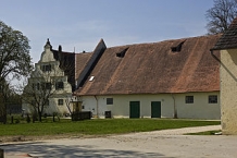
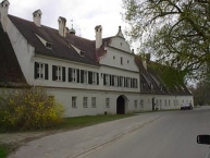
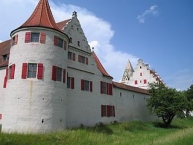
Rohrenfeld ist ein Stadtteil der großen Kreisstadt Neuburg an der Donau ![]() in Bayern, der etwa 7,5 Kilometer östlich Stadtzentrums liegt.
in Bayern, der etwa 7,5 Kilometer östlich Stadtzentrums liegt.
Rohrenfeld war ursprünglich ein landwirtschaftliches Gestüt und ist seit 1923 im Besitz des Wittelsbacher Ausgleichsfonds ![]() .
.
Information about copyright | |
|---|---|
Rights characteristic / license | by-sa: CREATIVE COMMONS Attribution-ShareAlike |
Link to the description of the license | |
Input taken over from: |
Seite „Rohrenfeld“. In: Wikipedia, Die freie Enzyklopädie. Bearbeitungsstand: 24. Dezember 2012, 20:43 UTC. URL: http://de.wikipedia.org/w/index.php?title=Rohrenfeld&oldid=112050189 (Abgerufen: 18. Februar 2013, 22:27 UTC) |
taken over / edited on | 18 Feb 2013
|
taken over / edited by |
|
81 km
0,1 km
375 m
Information about copyright | |
|---|---|
Rights owner | |
Rights characteristic / license | by: CREATIVE COMMONS Attribution |
Link to the description of the license | |
Image taken over from | |
Image has been uploaded | by biroto-Redaktion on 18 Feb 2013
|
Information about copyright | |
|---|---|
Rights owner | |
Rights characteristic / license | by-sa: CREATIVE COMMONS Attribution-ShareAlike |
Link to the description of the license | |
Image taken over from | |
Image has been uploaded | by biroto-Redaktion on 18 Feb 2013
|
Information about copyright | |
|---|---|
Rights owner | |
Rights characteristic / license | by-sa: CREATIVE COMMONS Attribution-ShareAlike |
Link to the description of the license | |
Image taken over from | |
Image has been uploaded | by biroto-Redaktion on 18 Feb 2013
|
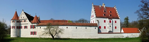
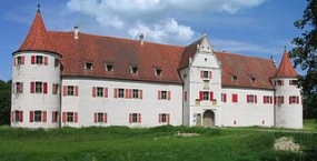
Das Jagdschloss Grünau liegt etwa sieben Kilometer östlich von Neuburg an der Donau ![]() im größten zusammenhängenden Auwaldgebiet Mitteleuropas.
im größten zusammenhängenden Auwaldgebiet Mitteleuropas.
Der Wittelsbacher ![]() Pfalzgraf Ottheinrich
Pfalzgraf Ottheinrich ![]() ließ das Jagdschloss für seine Ehefrau Susanna von Bayern
ließ das Jagdschloss für seine Ehefrau Susanna von Bayern ![]() errichten. Der Baubeginn des im Renaissance-Stil errichteten Schlosses erfolgte etwa 1530, die Fertigstellung 1555.
errichten. Der Baubeginn des im Renaissance-Stil errichteten Schlosses erfolgte etwa 1530, die Fertigstellung 1555.
Ursprünglich wurde Grünau als Wasserschlosserbaut, allerdings sind die Gräben inzwischen verlandet. Heute befindet sich das Jagdschloss im Besitz des Wittelsbacher Ausgleichsfonds ![]() .
.
Nutzung
Im Jagdschloss Grünau werden kulturelle Veranstaltungen, wie beispielsweise Konzerte veranstaltet. Seit 2005 finden hier manchmal im Mai Gartentage und im Dezember ein Weihnachtsmarkt statt.
Im Rahmen des Naturschutz-Großprojektes „Dynamisierung der Donauauen zwischen Neuburg und Ingolstadt“ ist hier seit dem 1. Januar 2008 das Aueninstitut Neuburg untergebracht. Am 19. April 2008 fand die Eröffnung des „Auenzentrums Neuburg“ statt.
Information about copyright | |
|---|---|
Rights characteristic / license | by-sa: CREATIVE COMMONS Attribution-ShareAlike |
Link to the description of the license | |
Input taken over from: |
Seite „Jagdschloss Grünau“. In: Wikipedia, Die freie Enzyklopädie. Bearbeitungsstand: 12. November 2012, 14:16 UTC. URL: http://de.wikipedia.org/w/index.php?title=Jagdschloss_Gr%C3%BCnau&oldid=110418634 (Abgerufen: 18. Februar 2013, 22:14 UTC) |
taken over / edited on | 18 Feb 2013 - 26 Feb 2013
|
taken over / edited by |
|
![]()