
Berlin-Usedom Island Cycle Route
Actions
![]()
Please wait - map data are loading
Added on 03 Jan 2012,
last edited by biroto-Redaktion on 27 Feb 2024
Actions
Cycle route metrics
Total distance in km
342
Information about rights to the gps-track data | |
|---|---|
Rights owner | OpenStreetMap and Contributors + biroto-Redaktion (biroto.eu) |
Rights characteristic / license | Contains information from OpenStreetMap, which is made available here under the Open Database License(ODbL) |
Link to the description of the license | |
GPX file taken from | |
GPX file uploaded | by biroto-Redaktion on 27 Feb 2024
|
Track points in total
4.455
Track points per km (avg)
13
Start/endpoint
Start location
Berlin, Berlin, DE (43 m NHN)
End location
Peenemünde, Mecklenburg-Vorpommern, DE (2 m NHN)
Signposting
|
|

Sources of information
Portale:
Bücher:
- Detlef Kaden: Unterwegs auf dem Berlin-Usedom Radfernweg: Ein Reiseführer
- Esterbauer bikeline: Radfernweg Berlin-Usedom
Von der Metropole an die Ostsee, Radtourenbuch, 330 km, 1: 50 000, wetterfest/reißfest
Beds4Cyclists, worth visiting and infrastructure
Name and address
Latitude / Longitude
Phone
Fax
Mobile
Type of accommodation
Rating for cyclists
Route km
Dist. to route
Elevation
0 km
2,5 km
37 m
0 km
0,1 km
29 m
Information about copyright | |
|---|---|
Rights owner | |
Rights characteristic / license | by-sa: CREATIVE COMMONS Attribution-ShareAlike |
Link to the description of the license | |
Image taken over from | commons.wikimedia.org/wiki/File:Brandenburger_Tor_abends.jpg |
Image has been uploaded | by biroto-Redaktion on 27 Aug 2012
|
Information about copyright | |
|---|---|
Rights owner | |
Rights characteristic / license | cc0: Public Domain no Rights reserved |
Link to the description of the license | |
Image taken over from | commons.wikimedia.org/wiki/File:Reichstag_Berlin_Sicherheit_1.jpg |
Image has been uploaded | by biroto-Redaktion on 27 Aug 2012
|

Information about copyright | |
|---|---|
Rights owner | |
Rights characteristic / license | by-sa: CREATIVE COMMONS Attribution-ShareAlike |
Link to the description of the license | |
Image taken over from | |
Image has been uploaded | by biroto-Redaktion on 27 Aug 2012
|
Information about copyright | |
|---|---|
Rights owner | |
Rights characteristic / license | by-sa: CREATIVE COMMONS Attribution-ShareAlike |
Link to the description of the license | |
Image taken over from | commons.wikimedia.org/wiki/File:German_Cathedral_and_Concert_Hall.JPG |
Image has been uploaded | by biroto-Redaktion on 27 Aug 2012
|
Mitte, literally meaning "the middle" and being a contraction of Stadtmitte (city centre), contains the historical heart of Berlin and represents in many ways the real center of the city. It is here where you will find the vast majority of the most popular sights.
It is important to note that "Mitte" can refer both to a larger district (Bezirk) and its smaller component (Ortsteil), which was a separate district until 2001 when the administrative division of Berlin changed. In this guide, we focus on the smaller Ortsteil Mitte, while covering some of the points of interest located right beyond its borders that are convenient to include in your tour of Mitte.
For other Ortsteile contained within the present-day Bezirk Mitte, such as Tiergarten, Moabit or Wedding, see Berlin/City West ![]() .
.
Understand
Administrative division
Before the reunification of Germany, Mitte was a district of East Berlin and the place where the Berlin Wall was most prominent, running right through the historic fabric of the city. Following reunification, the old administrative division was kept for a decade, and the Mitte's borders were unchanged, but it slowly merged with neighbouring districts of former West Berlin, Tiergarten and Wedding.
In 2001, the hitherto Mitte, Tiergarten and Wedding were merged into a new district, called Bezirk Mitte. The former districts became localities (Ortsteile) of the Bezirk Mitte. This may lead to confusion, as both the Ortsteil and Bezirk are referred to as "Mitte" in the common parlance and many written texts. It is generally safer to assume that most Berliners would refer to "Mitte" as the Ortsteil and former district, which is smaller and more cohesive.
As the administrative divisions serve other functions than just helping travellers, this guide oversteps the boundaries of the Ortsteil Mitte and includes some neighbouring parts located in other Ortsteile of the Bezirk Mitte, including the Spreebogen or Potsdamer Platz areas.
Areas of Mitte
The old district Mitte as covered in this guide can be divided into several neighborhoods:
- Unter den Linden — the main boulevard, from Museum Island to Brandenburg Gate, crossing the main shopping street, Friedrichstraße, half-way along.
- Museumsinsel (Museum Island) and Lustgarten (the square in front of the Altes Museum and adjacent to the Berlin Cathedral).
- Nikolaiviertel — a quarter near Alexanderplatz which comes close to old town style, but built by the East German government.
- Spandauer Vorstadt with Scheunenviertel — The Spandauer Vorstadt is located north of the River Spree and the Hackescher Markt. It is bordered on the north by the east-west course of the Torstraße, on the east by Karl-Liebknecht-Straße and by the northern part of Friedrichstraße to the west. The eastern part of the area takes its name Scheunenviertel (the "Barn Quarter") from the move in 1672 by the Great Elector of all the hay barns out of the fire-prone city center. In the late 19th century, the area became a refuge for Jews fleeing persecution and pogrom in Russia and Poland. By then it was the center of Jewish life in Berlin.
- Potsdamer Platz — the area around the completely razed Potsdamer Platz became no man's land between East and West Berlin and remained an empty strip of land until the 1990s, when it was rebuilt as a large project including striking highrises of concrete and steel, mixing offices and commercial space.
- Spreebogen/Regierungsviertel — "Spreebogen" means "the bow of the river Spree" and in Berlin generally refers to a particular one, where Spree meets the Berlin-Spandau Canal. The area around it houses the German federal government's institutions on the south (or left) bank, called Regierungsviertel ("government district"), while directly opposite it you will find Berlin's all-new central train station Hauptbahnhof.
See
Dorotheenstadt/Unter den Linden
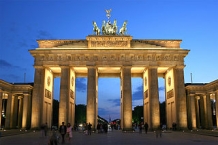
- ⊙Brandenburg Gate (Brandenburger Tor), Pariser Platz. The only surviving Berlin city gate and a potent symbol of the city. This is the point where Straße des 17. Juni becomes Unter den Linden. The gate was designed by Carl Gotthard Langhans in 1791 and was intended to resemble the Acropolis in Athens. The Brandenburg Gate now symbolizes reunification, after dividing East and West Berlin for decades
- ⊙Pariser Platz. The large square in front of the Brandenburg Gate contains the French and American embassies, the rebuilt Hotel Adlon, and the new building of the Academy of Arts.
- ⊙Russische Botschaft (Russian Embassy), Unter den Linden 55/65. A vast wedding cake of a building, built between 1949-1951 in the best Stalinist style and meant to symbolize the dominance of the Soviet Union in East German affairs before 1989.
- ⊙Neue Wache (New Guardhouse), Unter den Linden 4. Erected in 1818 to a classically-inspired design by Karl Friedrich Schinkel as a guardhouse for the imperial palace, since 1993 this compact building has housed a small, but extremely powerful war cenotaph, the Central Memorial of the Federal Republic of Germany, continuing its use under East German rule as the primary "Memorial to the Victims of Fascism and Militarism". The interior of the Doric column-fronted building is intentionally empty, but for a small but moving sculpture by Käthe Kollwitz depicting a mother cradling a dead child. The statue is positioned beneath a round hole in the ceiling, exposing the figures to the rain and snow.
- ⊙The Bebelplatz (formerly Opernplatz). Nazi Propaganda Minister Josef Goebbels made Bebelplatz (then called Opernplatz) infamous on 10 May 1933, when he used the square across from Humboldt University to burn 20,000 books by "immoral" authors of whom the Nazis did not approve. Their list included Thomas and Heinrich Mann, Arnold Zweig, Kurt Tucholsky and Sigmund Freud. Today a monument is the reminder, though it blames Nazi students for the episode. When entering the square it's easy to miss the monument. Look dead centre: the monument is underground. A piece of plexiglass allows the viewer to look underground into a large, white room, filled with entirely empty, blank white bookcases. The absence of books reminds the viewer just what was lost here: ideas. But the event did reveal things to come, as ethnically Jewish author and philosopher Heinrich Heine, whose books were burned, let one of his characters say in an 1821 play: "This was only the foreplay. Where they burn books, they will also burn people." He was correct.
- ⊙Deutsches Historisches Museum (German Historical Museum), Unter den Linden 2), ☎ +49 30 203040. 10:00–18:00. German historical museum covering everything from pre-history up to the present day. One can spend many, many hours here! The building from 1695/1730 was the Zeughaus (Arsenal) until 1876. €8, concession €4, under-18s free.
- ⊙Friedrichswerdersche Kirche, Werderscher Markt 1. Closed until further notice. Nice church located near Unter den Linden/Museum Island, finished in 1830 by Schinkel in English Neogothic style. Nice exhibition inside (neoclassical statues and an exhibition about Schinkel's life and work upstairs). Free. (updated Sep 2016)
- ⊙St.-Hedwigs-Kathedrale. Domed Church located at Bebelplatz/Unter den Linden, the oldest (mid-18th century) and one of the biggest Catholic churches in Berlin. Interior was redesigned in a modern style in the 1950s – but still many treasure chambers in the basement.
- ⊙Tränenpalast (Palace of Tears), Reichstagsufer 17 (just north of Friedrichstraße station), ☎ +49 30 4677779 11. Tu–F 09:00–19:00, Sa Su 10:00–18:00. Millions of visitors leaving East Berlin by train said tearful goodbyes to their friends and relatives from the East at this former border checkpoint. Hardly a year after the wall came down, the building was turned into a nightclub until it was forced to close in 2006. It re-opened as a museum in September 2011 and now houses a permanent exhibition that brings the absurd normality of everyday life in the divided city back to life. Free.
Friedrichstadt
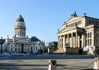
- Gendarmenmarkt. The Gendarmenmarkt is a square in the Friedrichstadt with the Konzerthaus (concert hall) and in front of the statue of Germany's poet Friedrich Schiller, the Deutscher Dom (German cathedrals) and the Französischer Dom (French cathedrals).
- ⊙Deutscher Dom (German Bundestag's historical exhibition), ☎ +49 30 229 1760. Tu–Su 10:00–18:00. Berlin’s Deutscher Dom on the magnificent Gendarmenmarkt square is not to be confused with the Berliner Dom. It was built in 1708. Since 1992 a German Parliament exhibition can be seen here entitled “Paths, Loosing Track and Detours” or the development of parliamentary democracy in Germany – ways and roundabouts. No religious services are held here. Free.
- ⊙Französischer Dom (Hugenottenmuseum), Gendarmenmarkt 5. Tu–Su 12:00–17:00. The Hugenottenmuseum represents the ongoing influence on Berlin by the Huguenots who emigrated from France after the revocation of the Edict of Nantes. Crown Prince Friedrich William encouraged them to settle here because most of them were skilled workers or otherwise useful to the kingdom. One memorable artwork, in room nine of the museum, pictures Crown Princess Dorothea exclaiming "But he's a refugee!" upon being presented a very valuable set of jewels by Pierre Fromery. The generally agreed-upon view of refugees as poor, without resources let alone diamonds, was blown apart by the talented French Protestants forced to leave their country due to religion. One of the most notable effects of having such a large French population was their influence on the infamous Berlin dialect. Berlinerisch words such as Kinkerlitzchen (from French "quincaillerie" - kitchen equipment) and Muckefuck (from French "mocca faux" - artificial coffee, though that etymology is not universally accepted) are unique to the area. The Französischen Dom (cathedral) itself was built to resemble the main church of the Huguenots in Charenton, France, destroyed in 1688. It has housed the museum since 1929. €2.
- ⊙Memorial for the Murdered Jews of Europe (Denkmal für die ermordeten Juden Europas), Ebertstraße 20, ☎ +49 2026 3943 36. Memorial open 24 hours, information centre Tu–Su 10:00–19:00. A vast Holocaust memorial designed by the American architect Peter Eisenman. Opened in the spring of 2005, this gigantic abstract artwork covering an entire block near the Brandenburg Gate, including an underground museum with extensive details on the Holocaust and the people who died during it. The blocks start out at ground level on the outer edges of the memorial, and then grow taller towards the middle, where the ground also slopes downwards. Free.
At the border to Kreuzberg
- ⊙Checkpoint Charlie. It was the only border crossing between East and West Berlin that permitted foreigners passage. Residents of East and West Berlin were not allowed to use it. This contributed to Checkpoint Charlie's mythological status as a meeting place for spies and other shady individuals. Checkpoint Charlie gained its name from the phonetic alphabet; checkpoints "Alpha" and "Bravo" were at the autobahn checkpoints Helmstedt and Dreilinden respectively. Checkpoint Charlie's atmosphere was not improved at all on 27 Oct 1961 when the two Cold War superpowers chose to face each other down for a day. Soviet and American tanks stood approximately 200 m apart, making an already tense situation worse. Now the remains of the Berlin Wall have been moved to permit building, including construction of the American Business Center and other institutions.
At the intersection of Zimmerstraße and Friedrichstraße (U-Bahn Kochstraße U6) is the famous "You Are Leaving the American Sector" sign. The actual guardhouse from Checkpoint Charlie is now housed at the Allied Museum on Clayallee. For a more interesting exhibit go to the Haus am Checkpoint Charlie. This is a private museum with kitschy memorabilia from the Wall and the devices GDR residents used to escape the East (including a tiny submarine!) - ⊙Topography of Terror, Kreuzberg, Niederkirchnerstraße 8. 10:00–20:00. This museum documents the terror applied by the Nazi regime. Also showing where the headquarters of various Nazi institutions responsible for genocide and other atrocities were throughout Berlin. Free.
- ⊙Martin-Gropius-Bau, Kreuzberg, Niederkirchnerstraße 7, ☎ +49 30 25486 0. W–M: 10:00–19:00. Exhibition hall. Around €10, varies between exhibits. Free for ages 16 and under.
Museumsinsel
- ⊙Pergamon Museum (Museumsinsel, new visitor entrance: Bodestraße 1-3). F–W 10:00–18:00, Th 10:00–20:00. There are three huge collections housed within this grand building: the Collection of Classical Antiquities, the Museum of Near Eastern Antiquities and the Museum of Islamic Art. The Pergamon Museum was the last museum built on Museumsinsel (Museum Island) and was intended to house the great acquisitions brought to Germany by archaeologists of the eighteenth and nineteenth century. The museum's best-known attraction is the Pergamonsaal. The Pergamon Altar (165 BC), from the eponymous Asia Minor city-state, is three stories high and served as the entrance gate to an entire complex. It is astounding both because of its size and extremely precise detail, especially in a frieze which shows the gods battling giants. The entire room is the same colour as the building's stone, making the details on the frieze section stand out even more. Facing the stairs, on the left hand side of the room there is a small-scale model of the altar which allows the viewer to see where the frieze segments would have been mounted. A 1:300 scale model of Pergamon city is on the right side of the room. The monumental market door of Milet has just been restored. Admission: €12, discounted: €6, children under age of 18 free.
- Part of the Antikensammlung (Collection of Classical Antiquities) — The most spectacular part of which is the reconstructed façade of the great altar of Pergamon. There is also the perhaps even greater Ish-Tar gate of Babylon, from centuries BC, which is reconstructed together with a stretch of the procession way.
- Vorderasiatisches Museum (Museum of the Ancient Near East)
- Museum für Islamische Kunst (Museum of Islamic Art) with the façade from Mshatta and the Aleppo Room.
- ⊙Neues Museum, Museumsinsel. F–W 10:00–18:00, Th 10:00–20:00. Admission: €12, discounted: €6, children under age of 18 free.
- Egyptian Museum and Papyrus Collection (Ägyptisches Museum und Papyrussammlung). Exhibits include the Egyptian and Prehistory and Early History collections. It houses the famous bust of Nefertiti (the legality of its acquisition is still contested by the Egyptian state which is trying to get it back, so you might want to hurry to see it there).
- Museum für Vor- und Frühgeschichte (Museum of Pre- and Early History). Museum for Pre- And Early History with objects from the Collection of Classical Antiquities in the Neues Museum.
- ⊙Altes Museum, Museumsinsel, Am Lustgarten. The main floor houses the antiquities collection in an ongoing exhibit called "Neue Antike im Alten Museum" (New Antiquities in the Old Museum). Directly through the front door, entering from the Lustgarten (Pleasure Garden, now under reconstruction), there is a domed rotunda with red and white cameos, Greek-style, with statues of the gods. To reach the Hildesheim silver collection, go to the back of the rotunda, turn left, walk through the long gallery and turn left into a small room at the end.
- ⊙Alte Nationalgalerie (Old National Gallery), Museumsinsel, Bodestraße 1-3, ☎ +49 30 2090 5801. Specializes in 19th century painting and sculpture; Monet, Manet, Cézanne, C. David Friedrich and other important 18th and 19th century artists are well-represented. Admission: €10, discounted: €5, children under age of 18 free.
- ⊙Bode-Museum, Museumsinsel, Monbijoustr. 3. F–W 10:00–18:00, Th 10:00–20:00. The museum’s treasures include the sculpture collection with works of art from the middle ages to the 18th century. The Bode museum is best known for its Byzantine art collection and the coin cabinet. Admission Fee: €8, red.: €4, children under age of 18 free.
- ⊙Berliner Dom (Berlin Cathedral), Am Lustgarten, ☎ +49 2020 26 9136. M-Sa 09:00–20:00, Su and holidays 12:00–20:00. The city's Protestant cathedral and the burial place of the Prussian kings. You can climb to the top and get a view of the city. €7.
- ⊙Stadtschloss – Humboldt-Forum (Berlin City Palace). Started in the 15th century and finished in the mid-18th century, the baroque palace was the residence of electors, kings and emperors until 1918, when it became a museum. The palace was badly damaged during World War II and later razed in 1950, replaced by the GDR with a modernist Palast der Republik. The Palast was in turn gradually dismantled at the turn of the century, as it was discovered to contain asbestos and its former function of housing the GDR parliament became obsolete. Berlin has started in June 2013 construction on a new version of its historic Stadtschloss. Now the building is scheduled to open in 2019.
Alexanderplatz / Alt-Berlin
The square used to host a cattle market (Ochsenplatz). It was named after the Russian Tsar Alexander I when he visited in 1805. It rose to prominence in the 19th century following the construction of railway and gradually became the eastern focal point of Berlin. The bustling area around the square was immortalized by Alfred Döblin in a monumental novel Berlin Alexanderplatz (1929).
The Alexanderplatz area was largely destroyed during the Second World War and redeveloped by socialist city planners as the new centre of East Berlin. The vast expanses of open spaces and large, imposing examples of modern architecture provide for a very different feel than the part of Mitte located across the Spree. Incidentally, the areas directly southwest of modern-day Alexanderplatz were the places where the city of Berlin originates from (Alt-Berlin), and many remains of that can be found interspersed between the modern architecture of the quarter.
Two of the highest buildings in Berlin, the Fernsehturm and the Park Inn hotel, dominate today's Alexanderplatz, while historic buildings such as the Rotes Rathaus, Marienkirche and the Nikolaiviertel flank its sides.
- ⊙Fernsehturm (Television tower), Panoramastraße 1A, ☎ +49 30 247575 37. Mar–Oct 09:00–00:00, Nov–Feb 10:00–00:00. At 368 metres, the Fernsehturm is Berlin's tallest and indeed EU's second-tallest building, complected between 1965 and 1969. The main function of the building is television broadcasting, but the shiny sphere atop the tower houses a viewing platform, a restaurant and a Berlin Tourist Information point. The viewing platform sits 203 metres above ground, affording views of as much as 42 km away and featuring a bar. The Sphere restaurant at 207 metres rotates at a speed of one full spin per 30 minutes. There are two lifts from the base to the platform and cafe, taking 40 seconds to reach the top, as well as a 986-step staircase. The Fernsehturm is not accessible to wheelchair users.
Not all of the Berliners liked the tower and the overall composition of the Alexanderplatz afforded by the socialist city planners, and they nicknamed the building "Telespargel" ("television asparagus"). During certain times of day, sunlight reflecting from the top caused a large cross-shaped light to shine down on the city. Called the Rache des Papstes (Pope's revenge) by nominally atheist East Berliners, the light-cross was an ironic result of socialist architecture. Rumour has it the architect was deprived of more than his next commission after that fiasco. At night, the Fernsehturm sometimes appears to be shooting light beams from the tower section, giving the impression it's a Death Star à la Star Wars. €13, children €8.50. - ⊙Weltzeituhr (World Clock), Alexanderplatz. Built in 1969, this 16-ton, communist-era clock is one of Berlin's main meeting points. Each of its 24 sides corresponds to one of Earth's 24 time zones and it has the names of some of the world's most important cities written on it.
- ⊙Neptunbrunnen. A bronze fountain by Reinhold Begas. It was erected in 1891 as a present from the city of Berlin to the Kaiser. Neptune, trident in hand, presides over the square supported by sea-nymphs with webbed feet carrying him on a seashell. Denizens of the deep (a seal, an alligator, snakes and turtles, among others) spray water at him in homage while languishing mermaids pour water into the fountain, clutching sea-nets overflowing with marine bounty.
- ⊙Rotes Rathaus (Red Town Hall). The town hall of Berlin is called so because it is made of red brick, not due to its former political persuasion. There are nice Prussian rooms inside, which are worth a look.
- ⊙Marienkirche (St. Mary's Church), Karl-Liebknecht-Straße (next to the Fernsehturm). Gothic church, the second oldest (built in late 13th century) of the historical centre of Berlin. It's the highest church tower of Berlin (about 90 m), but seems rather small beneath the gigantic TV tower. The church tower was built in the late 18th century by Carl Gotthard Langhans, the architect of the Brandenburg Gate.
- ⊙Domaquaree, Karl-Liebknecht Straße (In the Radisson BLU hotel). The twin buildings of the complex house the Radisson Hotel and the Sea Life Centre. In the Radisson lobby you can have a quick glance at the famous Aquadom, the world's biggest cylindrical aquarium with a built-in elevator. There is no entrance fee for watching, but for taking a trip with the elevator you have to pay the entrance fee for the whole Sea Life Centre.
- ⊙Nikolaikirche (St. Nicholas Church), Nikolaikirchplatz, ☎ +49 30 24002 162. daily 10:00–18:00. Berlin's oldest church (1230) is a 3-nave hall church. It is in the center of an area destroyed by bombs in the war which was then turned into a faux "old town" by the East German authorities called Nikolaiviertel. The area is more a hodge-podge of relocated buildings than an authentic reproduction, and the newly-built 1988 apartments that attempt to "harmonize" with the older buildings are embarrassing. The church is one of the only structures that was renovated rather than rebuilt. It is best known for a sandstone sculpture called the Spandauer Madonna (1290), but there are other interesting pieces here. When the church was destroyed in 1938 and rebuilt in the 1970s, the communist officials intended to use it as a museum, which did not open until 1987. The museum includes sacred textiles and religious sculpture from the fourteenth to the sixteenth centuries. The Nikolaikirche is the showplace of the Nikolaiviertel, which isn't saying much. €5.
- ⊙Zille Museum, Propststraße 11, ☎ +49 30 24632 502. A museum in Nikolaiviertel dedicated to the Berliner artist Heinrich Zille.
- ⊙DDR Museum, Karl-Liebknecht-Straße 1 (across from Berliner Dom on the banks of River Spree), ☎ +49 30 84712373 1. Su–F 10:00–20:00, Sa 10:00–22:00. A museum dedicated to everyday life in communist East Germany. The museum has very relaxed rules and you are allowed to touch and examine almost every object, which adds greatly to the experience. €7, concession €4.
Spreebogen / Regierungsviertel
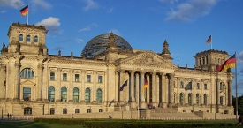
- ⊙Reichstag. This imposing building houses the Federal German Parliament or "Bundestag" and was completed in 1894 to meet the need of the newly-unified German Empire of the Kaisers' for a larger parliamentary building. The Reichstag was intended to resemble a Renaissance palace, and its architect, Paul Wallot, dedicated the building to the German people. The massive inscription in front still reads: "Dem Deutschen Volke" - 'For the German people'. The Nazi leader Adolf Hitler exploited the fire which gutted the Reichstag building in 1933 by blaming the Communists for the arson and for attempted revolution. There is good evidence to suggest, however, that his followers were actually responsible and that this was a manufactured crisis. When German reunification became a reality, the new republic was proclaimed here at midnight on 2 October 1990. The Reichstag has undergone considerable restoration and alteration, including the addition of a spectacular glass dome designed by the British architect Norman Foster. The Reichstag building is well-known in the art world thanks to Paris-based Bulgarian artist Christo's mammoth 'Wrapped Reichstag' project in 1995. The entire building was swathed in silver cloth for two weeks that summer. You can visit the glass dome or a parliamentary debate on your own or follow along on a guided tour through the building. Free, but pre-booking is required, sometimes weeks in advance. Bring valid ID.
- ⊙Bundeskanzleramt (Chancellor's Office).
- ⊙Berliner Medizinhistorisches Museum der Charité. Charitéplatz 1. Interesting exhibition charting the development of European hospitals from the 14th Century to the present day.
Spandauer Vorstadt
- ⊙Neue Synagoge (New Synagogue), Oranienburger Straße 28/30, ☎ +49 30 8802 8300. Museum: €3.50, Dome: €2.
- ⊙Old Jewish Cemetery (Alter Jüdischer Friedhof), Große Hamburger Straße. €9-12 for tours.
Potsdamer Platz / Kulturforum
The Potsdamer Platz and the neighbouring Leipziger Platz were important squares in pre-war Berlin, but were almost entirely razed during the Second World War, and in the aftermath they became a strip of no man's land separating East and West Berlin. To bring together the disjointed city, a large-scale project was initiated after the German reunification to fill in the empty space with large, impressive and modern buildings, housing corporate headquarters, commercial and entertainment venues and upscale apartments. Today, the Potsdamer Platz is a major draw for tourists and a lively hub of Berlin.
Immediately west off Potsdamer Platz begins the Kulturforum, an ensemble of buildings housing cultural institutions built on the outskirts of the former West Berlin, as most of the seats of former cultural institutions of Berlin remained in the East. The buildings of the Kulturforum represent the various bold styles of architecture of the 1950s and 1960s.
The border between Mitte and Tiergarten runs right across the Potsdamer Platz, and most of the buildings and institutions described here are actually in Tiergarten, but for the sake of making this guide more useful are described along with the others which fall in Mitte proper. For points of interest lying further West, see Berlin/City West ![]() .
.
- ⊙Kollhoff Tower (Potsdamer Platz
 ). 10:00–20:00. Includes the Panoramapunkt, the viewing terrace located 101 metres above ground, accessible by Europe's fastest elevator. €6.50, concession €5.
 - ⊙Sony Center. With an impressive, circus-tent-like roof over its courtyard and remains of the pre-war Hotel Esplanade incorporated into the modern structure.
- ⊙Leipziger Platz. The octagonal square right east of Potsdamer Platz was recreated to resemble its pre-war layout, but the buildings are modern rather than historic replicas and much taller than their counterparts from before the war. There is a diverse mix of uses among the buildings, which include the Embassy of Canada.
- ⊙Neue Staatsbibliothek (Berlin State Library House Potsdamer Straße). designed by Hans Scharoun.
- ⊙Gemäldegalerie (Old Master Paintings), Matthäikirchplatz (Stauffenbergstraße 40), ☎ +49 30 2662101. Tu W F 10:00–18:00, Th 10:00–20:00, Sa Su 11:00–18:00, M closed. The Gemäldegalerie contains an astounding array of paintings, including works by Rembrandt, Rubens, Botticelli, Raphael, Titian, Goya, Velasquez and Watteau. The collection contains works from the old Bodemuseum on Museumsinsel in the East, now closed, and the former Gemäldegalerie in Dahlem. Its strong points are German paintings of the 13-16th centuries, Netherlandish painting of the 15th and 16th centuries, Flemish paintings of the 17th century, and miniature paintings of the 16th-19th centuries. In the newer section of the museum, designed by architects Heinz Hilmer and Christoph Sattler, there is enough space to display 1,150 masterpieces in the main gallery and 350 in the studio gallery - of the almost 2,900 pieces in the European painting collections. Established in 1830, the newly built gallery from 1998 has about 7,000 sq m of exhibition space (a complete tour of the 72 rooms covers almost 2 km). €14, concession €7; Kulturforum all exhibitions: €16, concessions €8.
- ⊙Neue Nationalgalerie (New National Gallery), Potsdamer Straße 50. Closed since 2015 for about 3 years due to the necessary renovations. Spectacular building by Mies van der Rohe contains its own collection and temporary exhibitions.
Oranienburger Vorstadt
- ⊙Berlin Wall Memorial (Gedenkstätte Berliner Mauer), Bernauer Straße 119, ☎ +49 30 464 1030. Memorial grounds daily 08:00–22:00. Visitor Center and Documentation Center: Tu–Su 10:00–18:00, M closed. Often missed by tourists but an absolute must for anyone interested in this part of the city's history. It's a memorial to those who died crossing, so you won't, fortunately, get the tackiness of the Checkpoint Charlie area; instead you will be left with a haunting feeling of what life with the wall may have been really like. The documentation centre across the street on Bernauer Straße is excellent although most of the documentation is in German. The viewing platform gives you a tiny hint of the true scale of the Wall and how terrifying the "no man's land" between the two sections of walls must have been. When the documentation centre is closed, both walls can be visited. There is some space between the concrete plates which allow you to look at the area between the walls. There are also several small holes.
The Memorial is on Bernauer Straße which itself is a street with a great deal of Wall history: the first recorded Wall-related death - the notorious Peter Fechter case (he bled to death in the "no-man's-land" with both sides unwilling or unable to help him) - was here, as was one of the famous tunnels and the famous photograph of the GDR border guard leaping over the barbed wire. Various monuments can be found along the entire length of the street, documenting nearby escape attempts and tunnels; captions are in German, English, French, and Russian. The Memorial itself is a complete section of 4th generation wall - both inside and outside sections, and you can peer through from the east side to see the remains of the electric fence and anti-tank devices in the death strip. It really helps you understand what an incredible feat it was to get from one side to the other -- and why so many died doing it. Free.
Information about copyright | |
|---|---|
Rights characteristic / license | by-sa: CREATIVE COMMONS Attribution-ShareAlike |
Link to the description of the license | |
Input taken over from: |
Wikivoyage contributors, 'Berlin/Mitte', Wikivoyage, The FREE worldwide travel guide that anyone can edit, 11 October 2016, 07:58 UTC, <https://en.wikivoyage.org/w/index.php?title=Berlin/Mitte&oldid=3064434> [accessed 14 October 2016] |
taken over / edited on | 27 Aug 2012 - 14 Oct 2016
|
taken over / edited by |
|
0 km
2,9 km
32 m
DE-10785 Berlin-Tiergarten
Hotel without restaurant (garni)
0 km
2,7 km
35 m
0 km
4,4 km
39 m
![]()