
Bridges Cycle Route
Actions
![]()
Please wait - map data are loading
Added on 17 Jul 2012,
last edited by biroto-Redaktion on 22 Nov 2020
Actions
Cycle route metrics
Total distance in km
313
Information about rights to the gps-track data | |
|---|---|
Rights owner | OpenStreetMap and Contributors + biroto-Redaktion (biroto.eu) |
Rights characteristic / license | Contains information from OpenStreetMap, which is made available here under the Open Database License(ODbL) |
Link to the description of the license | |
GPX file taken from | |
GPX file uploaded | by biroto-Redaktion on 22 Nov 2020
|
Track points in total
3.443
Track points per km (avg)
11
Start/endpoint
Start location
Bremen, Bremen, DE (10 m NHN)
End location
Bremen, Bremen, DE (9 m NHN)
Character
Der Brückenradweg ist ein Radfernweg von rund 314 km Länge im west- nordwestlichen Niedersachsen und Bremen, der die ehemaligen Hansestädte Bremen und Osnabrück auf zwei weitgehend parallelen Trassen miteinander verbindet. Damit schlägt dieser Weg eine Brücke zwischen den beiden Städten, sein Name steht jedoch auch für die vielen Einzelbrücken, die im Verlauf der beiden Teilrouten zu überqueren sind.
Information about copyright | |
|---|---|
Rights characteristic / license | by-sa: CREATIVE COMMONS Attribution-ShareAlike |
Link to the description of the license | |
Input taken over from: |
Seite „Brückenradweg“. In: Wikipedia, Die freie Enzyklopädie. Bearbeitungsstand: 24. Juni 2012, 00:41 UTC. URL: http://de.wikipedia.org/w/index.php?title=Br%C3%BCckenradweg&oldid=104734343 (Abgerufen: 17. Juli 2012, 18:13 UTC) |
taken over / edited on | 17 Jul 2012
|
taken over / edited by |
|
Signposting
|

Beds4Cyclists, worth visiting and infrastructure
Name and address
Latitude / Longitude
Phone
Fax
Mobile
Type of accommodation
Rating for cyclists
Route km
Dist. to route
Elevation
0 km
0,6 km
13 m
0 km
0,1 km
18 m
1 km
0,8 km
9 m
1 km
0,0 km
18 m
Information about copyright | |
|---|---|
Rights owner | |
Rights characteristic / license | by-sa: CREATIVE COMMONS Attribution-ShareAlike |
Link to the description of the license | |
Image taken over from | https://commons.wikimedia.org/wiki/File:Bremen_Domshof_Dom_20h00.jpg |
Image has been uploaded | by biroto-Redaktion on 17 Nov 2016
|
Information about copyright | |
|---|---|
Rights owner | |
Rights characteristic / license | by-sa: CREATIVE COMMONS Attribution-ShareAlike |
Link to the description of the license | |
Image taken over from | https://commons.wikimedia.org/wiki/File:Schütting_-_front_-_jh15.jpg |
Image has been uploaded | by biroto-Redaktion on 17 Nov 2016
|
Information about copyright | |
|---|---|
Rights owner | |
Rights characteristic / license | by-sa: CREATIVE COMMONS Attribution-ShareAlike |
Link to the description of the license | |
Image taken over from | https://commons.wikimedia.org/wiki/File:Bremen_Stadtmusikanten.jpg |
Image has been uploaded | by biroto-Redaktion on 17 Nov 2016
|
Information about copyright | |
|---|---|
Rights owner | |
Rights characteristic / license | cc0: Public Domain no Rights reserved |
Link to the description of the license | |
Image taken over from | |
Image has been uploaded | by biroto-Redaktion on 17 Nov 2016
|
The free Hanseatic City of Bremen is a city in northern Germany with a major port on the River Weser. The population is 548,000. It is also the name of one of the states of Germany which consists of two separated enclaves on the River Weser.
Understand
History
Bremen was once a member of the medieval Hanseatic League and is still one of the most important cities in northern Germany. Bremen has more than 1200 years of history, and was, for most of its existence, an independent city-state.
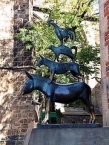
Bremer Stadtmusikanten
The Bremer Stadtmusikanten (Town Musicians of Bremen) perhaps the most well known figures associated with Bremen are characters from the Brothers Grimm fairy tale of the same name. Their image adorns many of the souvenirs in the city. Next to the Town Hall is a much photographed statue of them.
See
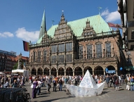
- ⊙Rathaus
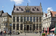
 (Town Hall). this is one of the finest in Europe and as such has been included on the UNESCO World Heritage List. Building work started in 1410 and it is seen as an important display of the wealth and freedom of the city. Tours of the interior are conducted by the Tourist information office at 11AM, noon, 3PM and 4PM.
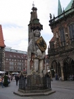
 - ⊙ Roland , Rathausplatz. this statue on the main square, in front of the town hall is of the Knight Roland who was a protector of trade. He appears in many European cities especially those involved in the Hanseatic league. Bremen's is considered one of the finest and is included with Town Hall on the World Heritage List. The standing figure is 5.47 m tall.
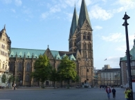
- ⊙Dom St. Petri (Cathedral of St Peter). is over 1200 years old, and its huge towered façade dominates the main square. the interior is impressive with some fine painted details on the ceilings. There is a treasury displaying the collection of the cathedral. Entrance is free, for €1 you can climb the Southern Tower offering nice views over the whole city.
- ⊙Böttcherstraße. Is the incredible Jugendstil (Art Nouveau) street that runs from the main square towards the river. There are many fine façades and courtyards all with large amounts of design detail. There is an impressive Glockenspiel that chimes at regular intervals. There are lots of shops and several museums, including the impressive Paula Modersohn-Becker Museum. Haus Atlantis (now the Hilton) has an impressive spiral staircase just inside, at the top of which is the staggering Himmelshaal (unfortunately it is not normally open to the public).
- ⊙Am Wall. is a lovely park next to the former defensive moat which offers a place to sit and relax. (updated Jan 2016)
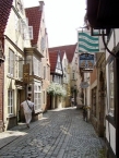
- ⊙Schnoor. this area of twisting lanes is a lovely place to wander aimlessly looking at in the many shops and also at the world smallest hotel (see Sleep).
Museums
- ⊙Überseemuseum (Natural History and Ethnographic Museum), 13, Bahnhofsplatz D (near central station), ☎ +49 421 16038101.
- ⊙Focke Museum, Schwachhauser Heerstrasse 240, ☎ +49 421 6996000. a good overview of the history of Bremen City with a wide range of collections
- ⊙Hafenmuseum Speicher XI, In the Überseestadt (Bus line 20 from railway station or tram line 3), ☎ +49 421 3038279. Housed in a former cotton warehouse. Models of ships used during the past.
Eat
Several cafes and restaurants line the ⊙ "Schlachte" along the Weser river while other popular areas are the marketplace and the "Viertel" ("quarter") east of the Kunsthalle. Many traditional dishes from Bremen and Northern Germany are very satisfying. The region is famous for cabbage (Grünkohl- green cabbage), fish (smoked eel, herring, smelt in March), an old sailor´s meal called Labskaus (lobscouse) consisting of mashed potatoes, corned beef, onions, fried egg and beetroot or chick ragout (very fine) as well as red fruit jelly or Butterkuchen (cake with yeast and topped with lots of butter, sugar and almonds). You can find some fish restaurants in Böttcherstraße. "Knigge" is the name of a traditional coffee house in Bremen.
Bremen culinary specialties are Knipp (smoked sausage), Labskaus, (fried corned beef with onions and mashed potatoes) and Braunkohl (leaf cabbage)
Budget
- ⊙Gasthof zum Kaiser Friedrich, Lange Wieren 13, ☎ +49 421 326429. Closed on Sundays. Slightly smoked cut of pork with cabbage and mashed potatoes (Braunkohlteller)
Information about copyright | |
|---|---|
Rights characteristic / license | by-sa: CREATIVE COMMONS Attribution-ShareAlike |
Link to the description of the license | |
Input taken over from: |
Wikivoyage contributors, 'Bremen', Wikivoyage, The FREE worldwide travel guide that anyone can edit, 17 September 2016, 14:22 UTC, https://en.wikivoyage.org/w/index.php?title=Bremen&oldid=3051837 |
taken over / edited on | 17 Nov 2016 - 20 May 2021
|
taken over / edited by |
|
1 km
0,1 km
11 m
Information about copyright | |
|---|---|
Rights owner | |
Rights characteristic / license | by-sa: CREATIVE COMMONS Attribution-ShareAlike |
Link to the description of the license | |
Image taken over from | |
Image has been uploaded | by biroto-Redaktion on 06 Apr 2012
|
Information about copyright | |
|---|---|
Rights owner | |
Rights characteristic / license | by-sa: CREATIVE COMMONS Attribution-ShareAlike |
Link to the description of the license | |
Image taken over from | commons.wikimedia.org/wiki/File:EKT09-Bremen_Marktplatz-01.jpg |
Image has been uploaded | by biroto-Redaktion on 06 Apr 2012
|
Information about copyright | |
|---|---|
Rights owner | |
Rights characteristic / license | by-sa: CREATIVE COMMONS Attribution-ShareAlike |
Link to the description of the license | |
Image taken over from | |
Image has been uploaded | by biroto-Redaktion on 06 Apr 2012
|
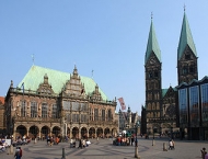
Das Bremer Rathaus ist eines der bedeutendsten Bauwerke der Gotik und der Weserrenaissance in Europa. Seit 1973 Steht es unter Denkmalschutz. Im Juli 2004 wurde es zusammen mit dem Bremer Roland ![]() von der UNESCO zum Weltkulturerbe der Menschheit ernannt.
von der UNESCO zum Weltkulturerbe der Menschheit ernannt.
Das Gebäude ist Sitz des Senats und des Präsidenten des Senats und Bürgermeisters der Freien Hansestadt Bremen ![]() .
.
Der Bremer Roland, eine 1404 errichtete Rolandsstatue auf dem Marktplatz ![]() vor dem Rathaus
vor dem Rathaus ![]() , ist ein Wahrzeichen Bremens.
, ist ein Wahrzeichen Bremens.
Die Figur hat eine Höhe von 5,47 Metern und steht auf einem 60 Zentimeter hohen, gestuften Podest. Im Rücken wird sie von einem Pfeiler gestützt, der von einem gotisch ornamentierten Baldachin gekrönt wird. So erreicht das Denkmal eine Gesamthöhe von 10,21 Metern und ist damit die größte freistehende Plastik des deutschen Mittelalters.
Information about copyright | |
|---|---|
Rights characteristic / license | by-sa: CREATIVE COMMONS Attribution-ShareAlike |
Link to the description of the license | |
Input taken over from: |
Seite „Bremer Rathaus“. In: Wikipedia, Die freie Enzyklopädie. Bearbeitungsstand: 2. März 2012, 20:21 UTC. URL: http://de.wikipedia.org/w/index.php?title=Bremer_Rathaus&oldid=100393680 (Abgerufen: 6. April 2012, 18:37 UTC) Seite „Bremer Roland“. In: Wikipedia, Die freie Enzyklopädie. Bearbeitungsstand: 20. März 2012, 12:51 UTC. URL: http://de.wikipedia.org/w/index.php?title=Bremer_Roland&oldid=101096161 (Abgerufen: 6. April 2012, 18:45 UTC) |
taken over / edited on | 06 Apr 2012 - 14 Dec 2013
|
taken over / edited by |
|
Hours of opening
Rathaus-Führung
Montag-Samstag 11, 12, 15, 16 Uhr
Sonntag 11, 12 Uhr
![]()