
Cycle Route Hiwwel-Route
Actions
![]()
Please wait - map data are loading
Added on 31 Jan 2018,
last edited by biroto-Redaktion on 02 Nov 2023
Actions
Cycle route metrics
Total distance in km
163
Information about rights to the gps-track data | |
|---|---|
Rights owner | OpenStreetMap and Contributors + biroto-Redaktion (biroto.eu) |
Rights characteristic / license | Contains information from OpenStreetMap, which is made available here under the Open Database License(ODbL) |
Link to the description of the license | |
GPX file taken from | |
GPX file uploaded | by biroto-Redaktion on 02 Nov 2023
|
Track points in total
2.390
Track points per km (avg)
15
Start/endpoint
Start location
Bingen am Rhein, RP, DE (83 m NHN)
End location
Worms, RP, DE (93 m NHN)
Character
Die Hiwwel-Route ist ein Radwanderweg in Rheinhessen, der auf rund 166 km die Städte Bingen am Rhein ![]() , Ingelheim am Rhein
, Ingelheim am Rhein ![]() , Mainz
, Mainz ![]() , Alzey
, Alzey ![]() und Worms
und Worms ![]() mit der rheinhessischen Hügellandschaft verbindet. Der Name des Radweges leitet sich aus der rheinhessischen Mundart ab – „Hiwwel“ bedeutet „Hügel“. Seinen Ausgang nimmt der Radweg in Bingen am Rhein. Anschließend streift er die Rheinhessische Schweiz und führt über Alzey zurück in die Rheinebene nach Worms.
mit der rheinhessischen Hügellandschaft verbindet. Der Name des Radweges leitet sich aus der rheinhessischen Mundart ab – „Hiwwel“ bedeutet „Hügel“. Seinen Ausgang nimmt der Radweg in Bingen am Rhein. Anschließend streift er die Rheinhessische Schweiz und führt über Alzey zurück in die Rheinebene nach Worms.
Die Hiwwel-Route greift vornehmlich auf asphaltierte Wirtschafts- und Radwege zurück. Die Strecke ist auf ca. 152 km asphaltiert bzw. betoniert, die restlichen 14 km verlaufen – in mehreren kleinen Teilstücken – auf wassergebundenen Schotterwegen. Der größte Teil der Strecke ist eben bis leicht hügelig.
Vereinzelt teilt sich die Route ihre Wegstrecke mit anderen Radwegen, wie dem Rhein- oder dem Selztalradweg.
Information about copyright | |
|---|---|
Rights characteristic / license | by-sa: CREATIVE COMMONS Attribution-ShareAlike |
Link to the description of the license | |
Input taken over from: |
Seite „Hiwwel-Route“. In: Wikipedia, Die freie Enzyklopädie. Bearbeitungsstand: 18. November 2017, 09:00 UTC. URL: https://de.wikipedia.org/w/index.php?title=Hiwwel-Route&oldid=171119875 |
taken over / edited on | 31 Jan 2018 - 02 Nov 2023
|
taken over / edited by |
|
Signposting
|

Beds4Cyclists, worth visiting and infrastructure
Name and address
Latitude / Longitude
Phone
Fax
Mobile
Type of accommodation
Rating for cyclists
Route km
Dist. to route
Elevation
0 km
2,5 km
78 m
0 km
3,5 km
133 m
Information about copyright | |
|---|---|
Rights owner | |
Rights characteristic / license | by-sa: CREATIVE COMMONS Attribution-ShareAlike |
Link to the description of the license | |
Image taken over from | |
Image has been uploaded | by biroto-Redaktion on 19 Dec 2011
|
Information about copyright | |
|---|---|
Rights owner | |
Rights characteristic / license | by-sa: CREATIVE COMMONS Attribution-ShareAlike |
Link to the description of the license | |
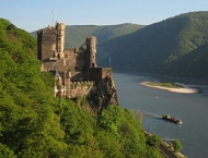
Image taken over from | commons.wikimedia.org/wiki/File:BurgRheinsteinInnenanlage.jpg |
Image has been uploaded | by biroto-Redaktion on 19 Dec 2011
|
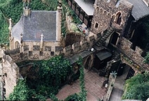
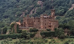
Die Burg Rheinstein (im Lauf ihrer Geschichte hieß sie eigentlich Vaitzburg oder Voitsberg; zahlreiche weitere Schreibweisen sind überliefert) ist eine Burg im oberen Mittelrheintal bei der Gemeinde Trechtingshausen im Landkreis Mainz-Bingen in Rheinland-Pfalz, Deutschland.
Seit 2002 ist die Burg Rheinstein Teil des UNESCO-Welterbes Oberes Mittelrheintal.Die Burg ist nach über dreißig Jahren Sanierungsarbeit aufwändig instandgesetzt und weitgehend wieder im Original ausgestattet. Sie befindet sich im Privatbesitz, ist aber zu regelmäßigen Öffnungszeiten entgeltlich zugänglich. Besonders sehenswert sind die zum großen Teil rekonstruierten Architekturmalereien und die restaurierten Glasfenster aus dem 14. bis 17. Jahrhundert. Auf der Burg befindet sich ein Gastronomiebetrieb; ein Turmappartment und eine Ferienwohnung auf der Burg können gemietet werden.
Information about copyright | |
|---|---|
Rights characteristic / license | by-sa: CREATIVE COMMONS Attribution-ShareAlike |
Link to the description of the license | |
Input taken over from: |
aus Wikipedia: Burg Rheinstein Stand 14.07.2011 |
taken over / edited on | 14 Jul 2011 - 19 Dec 2011
|
taken over / edited by |
|
Hours of opening
In der Hauptsaison (15.03. bis 01.11) ist die Burg täglich für Sie geöffnet von 09.30 bis 18.00 Uhr. Letzter Einlass: 17.30 Uhr.
0 km
4,9 km
108 m
Information about copyright | |
|---|---|
Rights owner | |
Rights characteristic / license | by-sa: CREATIVE COMMONS Attribution-ShareAlike |
Link to the description of the license | |
Image taken over from | |
Image has been uploaded | by biroto-Redaktion on 19 Dec 2011
|
Information about copyright | |
|---|---|
Rights owner | |
Rights characteristic / license | by-sa: CREATIVE COMMONS Attribution-ShareAlike |
Link to the description of the license | |
Image taken over from | |
Image has been uploaded | by biroto-Redaktion on 19 Dec 2011
|
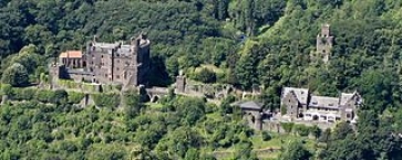
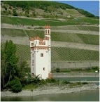
Die Burg Reichenstein, auch Falkenburg genannt, ist eine Burg im UNESCO-Welterbe Oberes Mittelrheintal. Sie steht auf einem Bergvorsprung am östlichen Abhang des Binger Walds oberhalb der rheinland-pfälzischen Gemeinde Trechtingshausen im Landkreis Mainz-Bingen. Die Stadt Bingen liegt nur etwa 5 km (Luftlinie) entfernt in Richtung Südosten.
Heutzutage beherbergt die Anlage ein Burgmuseum mit einer großen Sammlung an historischen Waffen und Rüstungen sowie gusseisernen Ofenplatten und ein Hotel mit Restaurant.
Information about copyright | |
|---|---|
Rights characteristic / license | by-sa: CREATIVE COMMONS Attribution-ShareAlike |
Link to the description of the license | |
Input taken over from: |
aus Wikipedia: Burg Reichenstein Stand 13.07.2011 |
taken over / edited on | 13 Jul 2011 - 19 Dec 2011
|
taken over / edited by |
|
0 km
2,5 km
79 m
0 km
0,8 km
76 m
Information about copyright | |
|---|---|
Rights owner | |
Rights characteristic / license | by-sa: CREATIVE COMMONS Attribution-ShareAlike |
Link to the description of the license | |
Image taken over from | |
Image has been uploaded | by biroto-Redaktion on 19 Dec 2011
|
Information about copyright | |
|---|---|
Rights owner | |
Rights characteristic / license | by-sa: CREATIVE COMMONS Attribution-ShareAlike |
Link to the description of the license | |
Image taken over from | commons.wikimedia.org/wiki/File:20070916_Maeuseturm_Bingen-am-Rhein_Rhineland-Pfalz_Germany.jpg |
Image has been uploaded | by biroto-Redaktion on 19 Dec 2011
|
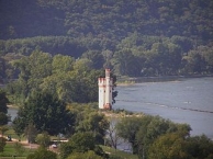
Der Binger Mäuseturm ist ein ehemaliger Wehr- und Wachturm. Er steht auf der Mäuseturminsel im Rhein vor dem Binger Stadtteil Bingerbrück. Die Stadt Bingen gibt die Höhe des Turms mit 24,65 Meter an.
Seit 2002 ist der Binger Mäuseturm Teil des UNESCO-Welterbes Oberes Mittelrheintal, des Weiteren ist er ein geschütztes Kulturgut nach der Haager Konvention.
Information about copyright | |
|---|---|
Rights characteristic / license | by-sa: CREATIVE COMMONS Attribution-ShareAlike |
Link to the description of the license | |
Input taken over from: |
aus Wikipedia: Binger Mäuseturm Stand 13.07.2011 |
taken over / edited on | 13 Jul 2011 - 19 Dec 2011
|
taken over / edited by |
|
![]()