
Lower Rhine Cycle Route
Actions
![]()
Please wait - map data are loading
Added on 25 Jan 2014,
last edited by biroto-Redaktion on 24 Nov 2020
Actions
Cycle route metrics
Total distance in km
1.303
Information about rights to the gps-track data | |
|---|---|
Rights owner | OpenStreetMap and Contributors + biroto-Redaktion (biroto.eu) |
Rights characteristic / license | Contains information from OpenStreetMap, which is made available here under the Open Database License(ODbL) |
Link to the description of the license | |
GPX file taken from | |
GPX file uploaded | by biroto-Redaktion on 24 Nov 2020
|
Track points in total
18.211
Track points per km (avg)
14
Start/endpoint
Start location
Duisburg, Nordrhein-Westfalen, DE (35 m NHN)
End location
Duisburg, Nordrhein-Westfalen, DE (35 m NHN)
Signposting
|

Beds4Cyclists, worth visiting and infrastructure
Name and address
Latitude / Longitude
Phone
Fax
Mobile
Type of accommodation
Rating for cyclists
Route km
Dist. to route
Elevation
0 km
0,0 km
38 m
0 km
0,5 km
39 m
0 km
0,0 km
46 m
0 km
1,0 km
42 m
1 km
0,3 km
20 m
Information about copyright | |
|---|---|
Rights owner | |
Rights characteristic / license | by-sa: CREATIVE COMMONS Attribution-ShareAlike |
Link to the description of the license | |
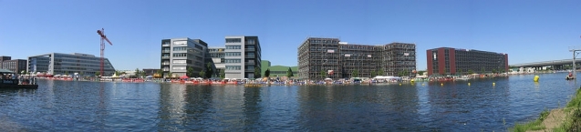
Image taken over from | commons.wikimedia.org/wiki/File:Duisburg_Innenhafenpanorama.jpg |
Image has been uploaded | by biroto-Redaktion on 02 Jan 2014
|
Information about copyright | |
|---|---|
Rights owner | Hans Peter Schaefer |
Rights characteristic / license | by-sa: CREATIVE COMMONS Attribution-ShareAlike |
Link to the description of the license | |
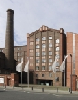
Image taken over from | commons.wikimedia.org/wiki/File:Duisburg_museum_küppersmühle_sammlg_grothe_vertikal.jpg |
Image has been uploaded | by biroto-Redaktion on 02 Jan 2014
|
Information about copyright | |
|---|---|
Rights owner | |
Rights characteristic / license | by-sa: CREATIVE COMMONS Attribution-ShareAlike |
Link to the description of the license | |
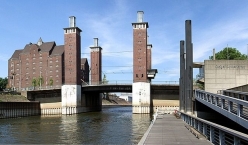
Image taken over from | commons.wikimedia.org/wiki/File:Duisburg_-_Schwanentorbrücke_1.jpg |
Image has been uploaded | by biroto-Redaktion on 02 Jan 2014
|
Information about copyright | |
|---|---|
Rights owner | |
Rights characteristic / license | by-sa: CREATIVE COMMONS Attribution-ShareAlike |
Link to the description of the license | |
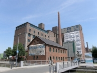
Image taken over from | commons.wikimedia.org/wiki/File:Werhahnmuehler_Duisburg_Innenhafen_Schornstein.jpg |
Image has been uploaded | by biroto-Redaktion on 02 Jan 2014
|
The Innenhafen (Inner Harbour) in Duisburg ![]() , encompassing an area of 89ha, was for over a hundred years, during the high point of the Industrial Revolution, the central harbour and trading point of the town. Since the mid-60s, the importance of the harbour declined and it lay in a disused condition for 20 years, before plans for renovation were drawn up. This former industrial area has been fundamentally transformed, a process which started as a part of the International Building Exhibition Emscher Park (IBA) which ran from 1989 until 1999.
, encompassing an area of 89ha, was for over a hundred years, during the high point of the Industrial Revolution, the central harbour and trading point of the town. Since the mid-60s, the importance of the harbour declined and it lay in a disused condition for 20 years, before plans for renovation were drawn up. This former industrial area has been fundamentally transformed, a process which started as a part of the International Building Exhibition Emscher Park (IBA) which ran from 1989 until 1999.
The basis for this model of development in the Ruhr district was delivered in 1994 by the British architect Norman Foster. Since then, the Inner Harbor has transformed itself into a district combining employment, housing, culture and water-based leisure activities. Today, the Inner Harbour is both an industrial monument and a main stop on the Route der Industriekultur ![]() .
.
Highlights of the newly renovated quarter of the Inner Harbour are the Küppersmühle ![]() converted to an arts museum by Herzog & de Meuron, the Werhahnmühle, which following the departure of the Children's Museum ATLANTIS is being used as a “Legoland
converted to an arts museum by Herzog & de Meuron, the Werhahnmühle, which following the departure of the Children's Museum ATLANTIS is being used as a “Legoland ![]() Discovery Centre“, the Cultural- and City History Museum, the “Garden of Remembrance“ laid out by Dani Karavan as well as the Synagoge of the Jewish District of Duisburg-Mülheim/Ruhr-Oberhausen, designed by the architect Zvi Hecker.
Discovery Centre“, the Cultural- and City History Museum, the “Garden of Remembrance“ laid out by Dani Karavan as well as the Synagoge of the Jewish District of Duisburg-Mülheim/Ruhr-Oberhausen, designed by the architect Zvi Hecker.
Additionally, on the far side of the Garden a marina has been built complete with a Buckelbrücke ('Buckle bridge' – for pedestrians). It is intended to extend the marina into the adjacent Holzhafen.
A lively dining-scene has also developed. In addition to more than 15 restaurants und clubs, there are also owner-run bars and franchises.
Information about copyright | |
|---|---|
Rights characteristic / license | by-sa: CREATIVE COMMONS Attribution-ShareAlike |
Link to the description of the license | |
Input taken over from: |
Wikipedia contributors, 'Duisburg Inner Harbour', Wikipedia, The Free Encyclopedia, 14 October 2013, 18:08 UTC, http://en.wikipedia.org/w/index.php?title=Duisburg_Inner_Harbour&oldid=577165288 [accessed 2 January 2014] |
taken over / edited on | 02 Jan 2014 - 08 Oct 2017
|
taken over / edited by |
|
![]()