
Radweg Mineralquellen- und Maare-Mosel-Route
Aktionen
![]()
Bitte warten - Kartendaten werden geladen
Erstellt am 03.07.2023,
zuletzt geändert von biroto-Redaktion am 22.07.2023
Aktionen
Strecken-Merkmale
Gesamtlänge in km
88
Gesamthöhenmeter Aufstieg
636
Durchschn. Steigung Aufstieg %
0,72
Gesamthöhenmeter Abstieg
834
Informationen zu Rechten an den GPS-Track-Daten | |
|---|---|
Rechte-Inhaber | OpenStreetMap and Contributors + biroto-Redaktion (biroto.eu) |
Rechte-Ausprägung / Lizenz | Enthält Daten von OpenStreetMap, die hier unter der Open Database License(ODbL) verfügbar gemacht werden |
Link zur Rechtebeschreibung | |
gpx-Datei übernommen aus | |
gpx-Datei hochgeladen | durch biroto-Redaktion am 22.07.2023
|
Gesamtzahl Trackpoints
1.533
Trackpoint-Dichte per km
17
Endorte
Start
Blankenheim, NW, DE (315 m NHN)
Ziel
Bernkastel-Kues, RP, DE (116 m NHN)
Charakter
Die Verbindung zwischen Ahr und Mosel.
Die Mineralquellen-Route ist ein Radwanderweg der als Verbindungsstück den Ahr-Radweg mit dem Maare-Mosel-Radweg und damit dem Liesertal verbindet. Vor Niederehe zweigt er aus dem Ahrtal kommend vom Kalkeifel-Radweg ab und führt hügelig nach Daun in der Vulkaneifel . Mit nur mäßiger Steigung überwindet er die Wasserscheide zwischen Rhein mit der Ahr als Nebenfluss und der Mosel, in welche die Lieser fließt. Die Radroute ist auch von Freizeitradlern gut zu bewältigen. Die Strecke ist in beiden Richtungen einheitlich mit dem Radweg-Logo gekennzeichnet.
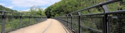
Der Maare-Mosel-Radweg ist ein Radwanderweg , der Daun in der Vulkaneifel ![]() über die ehemaligen Bahnnebenstrecken Daun–Wengerohr und Wengerohr–Bernkastel-Kues mit dem Moseltal verbindet. Auf der alten Bahntrasse geht es mit höchstens 3 % Steigung über Viadukte, Brücken, durch Tunnel und die Eifelwälder hinunter ins Moseltal. Der vom Vulkanismus und den Maaren geprägte Teil der Eifel wird abgelöst von der Kulturlandschaft des Weinbaus an der Mosel , die bei der Ortschaft Lieser erreicht wird. Auf der restlichen Strecke bis Bernkastel-Kues folgt die Route dem Mosel-Radweg . Teilweise folgt die Streckenführung dem Lauf der Mosel-Nebenflüsse Alf und Lieser . Die durchgehend asphaltierte Strecke ist für Freizeitradler und Familien mit Kindern geeignet.
über die ehemaligen Bahnnebenstrecken Daun–Wengerohr und Wengerohr–Bernkastel-Kues mit dem Moseltal verbindet. Auf der alten Bahntrasse geht es mit höchstens 3 % Steigung über Viadukte, Brücken, durch Tunnel und die Eifelwälder hinunter ins Moseltal. Der vom Vulkanismus und den Maaren geprägte Teil der Eifel wird abgelöst von der Kulturlandschaft des Weinbaus an der Mosel , die bei der Ortschaft Lieser erreicht wird. Auf der restlichen Strecke bis Bernkastel-Kues folgt die Route dem Mosel-Radweg . Teilweise folgt die Streckenführung dem Lauf der Mosel-Nebenflüsse Alf und Lieser . Die durchgehend asphaltierte Strecke ist für Freizeitradler und Familien mit Kindern geeignet.
Informationen zu Urheber-Rechten | |
|---|---|
Rechte-Ausprägung / Lizenz | by-sa: CREATIVE COMMONS Namensnennung, Weitergabe unter gleichen Bedingungen |
Link zur Rechtebeschreibung | |
Text(e) übernommen von: |
|
übernommen / bearbeitet am | 03.07.2023
|
übernommen / bearbeitet durch |
|
Wegweisung
Mineralquellen-Route |
|
Maare-Mosel-Radweg |
|


Reiseberichte über Fahrradtouren
Informationen zu Urheber-Rechten | |
|---|---|
Rechte-Inhaber | |
Rechte-Ausprägung / Lizenz | by-sa: CREATIVE COMMONS Namensnennung, Weitergabe unter gleichen Bedingungen |
Link zur Rechtebeschreibung | |
Bild hochgeladen | durch ThimbleU am 28.08.2023
|
18.07.2023
74 km
Eine Etappe der Tour »Aachen - Vennbahn - Mosel - Saar - Mosel - Erft - Solingen« von Anwender ThimbleU
Informationen zu Urheber-Rechten | |
|---|---|
Rechte-Inhaber | |
Rechte-Ausprägung / Lizenz | by-sa: CREATIVE COMMONS Namensnennung, Weitergabe unter gleichen Bedingungen |
Link zur Rechtebeschreibung | |
Bild hochgeladen | durch ThimbleU am 28.08.2023
|
17.07.2023
56 km
Eine Etappe der Tour »Aachen - Vennbahn - Mosel - Saar - Mosel - Erft - Solingen« von Anwender ThimbleU
Fahrradfreundliche Unterkünfte, Sehenswertes und Infrastruktur
Name u. Anschrift
Breite / Länge
Tel.
Fax.
Mobile
Art d. Unterkunft
Radler-freund-lichkeit
Strecken-km
km zur Strecke
Höhe
0 km
1,6 km
322 m
0 km
0,4 km
326 m
1 km
3,3 km
349 m
8 km
2,9 km
448 m
Informationen zu Urheber-Rechten | |
|---|---|
Rechte-Inhaber | |
Rechte-Ausprägung / Lizenz | by-sa: CREATIVE COMMONS Namensnennung, Weitergabe unter gleichen Bedingungen |
Link zur Rechtebeschreibung | |
Bild übernommen aus | https://commons.wikimedia.org/wiki/File:2017-06-04-Burg_Kerpen-0038.jpg |
Bild hochgeladen | durch biroto-Redaktion am 09.01.2021
|
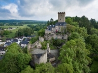
Die Burg Kerpen ist eine Spornburg auf einem Dolomitsporn in 500 m ü. NHN im Eifelort Kerpen ![]() in Rheinland-Pfalz.
in Rheinland-Pfalz.
Die Burg Kerpen ist eine dreiterrassige Spornanlage, die im Norden durch einen etwa 15 Meter breiten Halsgraben zum Berg hin gesichert ist. Der zinnenbewehrte, 23 Meter hohe Bergfried steht auf der ersten, am höchsten gelegenen Terrasse. In seinem obersten Geschoss befand sich früher ein Verlies.
Auf der mittleren Terrasse standen früher Neben- und Wirtschaftsgebäude, die heute nicht mehr existieren. Einziges Relikt aus der mittelalterlichen Zeit ist der 35 Meter tiefe Brunnen in einem Rondellbau.
Die unterste Terrasse ist von einer Umfassungsmauer umgeben, die von starken Pfeilern gestützt wird. Sie beherbergte noch im 17. Jahrhundert einige Neben- und Burgmannenhäuser, ehe diese 1682 von französischen Truppen zerstört wurden.
Informationen zu Urheber-Rechten | |
|---|---|
Rechte-Ausprägung / Lizenz | by-sa: CREATIVE COMMONS Namensnennung, Weitergabe unter gleichen Bedingungen |
Link zur Rechtebeschreibung | |
Text(e) übernommen von: |
Seite „Burg Kerpen (Eifel)“. In: Wikipedia, Die freie Enzyklopädie. Bearbeitungsstand: 28. November 2020, 10:58 UTC. URL: https://de.wikipedia.org/w/index.php?title=Burg_Kerpen_(Eifel)&oldid=206011700 (Abgerufen: 9. Januar 2021, 16:35 UTC) |
übernommen / bearbeitet am | 09.01.2021
|
übernommen / bearbeitet durch |
|
8 km
1,4 km
411 m
![]()