
Cycle Route Via Raetica
Actions
![]()
Please wait - map data are loading
Added on 14 Jun 2014,
last edited by biroto-Redaktion on 21 Oct 2023
Actions
Cycle route metrics
Total distance in km
189
Information about rights to the gps-track data | |
|---|---|
Rights owner | |
Rights characteristic / license | cc0: Public Domain no Rights reserved |
Link to the description of the license | |
GPX file uploaded | by biroto-Redaktion on 21 Oct 2023
|
Track points in total
3.160
Track points per km (avg)
17
Start/endpoint
Start location
Regensburg, BY, DE (336 m NHN)
End location
Donauwörth, BY, DE (400 m NHN)
Travel to and from ...
Sehr gute Bahnverbindung in Regensburg und Donauwörth.
Connecting cycle path
- Via Claudia
- Via Danubia
- Donauradweg
- Altmühltalradweg
Beds4Cyclists, worth visiting and infrastructure
Name and address
Latitude / Longitude
Phone
Fax
Mobile
Type of accommodation
Rating for cyclists
Route km
Dist. to route
Elevation
0 km
0,4 km
319 m
Information about copyright | |
|---|---|
Rights owner | Hytrion |
Rights characteristic / license | by-sa: CREATIVE COMMONS Attribution-ShareAlike |
Link to the description of the license | |
Image taken over from | de.wikipedia.org/wiki/Steinerne_Brücke#mediaviewer/File:Regensburg_-_Steinerne_Bruecke_ohne_Dom.jpg |
Image has been uploaded | by Ottocolor on 08 Sep 2014
|
Information about copyright | |
|---|---|
Rights owner | Nikater |
Rights characteristic / license | by-sa: CREATIVE COMMONS Attribution-ShareAlike |
Link to the description of the license | |
Image taken over from | de.wikipedia.org/wiki/Steinerne_Brücke#mediaviewer/File:R-steinernebrücke01.jpg |
Image has been uploaded | by Ottocolor on 08 Sep 2014
|
Information about copyright | |
|---|---|
Rights owner | Dr. Bernd Gross |
Rights characteristic / license | by-sa: CREATIVE COMMONS Attribution-ShareAlike |
Link to the description of the license | |
Image taken over from | de.wikipedia.org/wiki/Steinerne_Brücke#mediaviewer/File:Steinerne_Brücke_Regensburg_15.JPG |
Image has been uploaded | by Ottocolor on 08 Sep 2014
|
Information about copyright | |
|---|---|
Rights owner | Warp |
Rights characteristic / license | by-sa: CREATIVE COMMONS Attribution-ShareAlike |
Link to the description of the license | |
Image taken over from | de.wikipedia.org/wiki/Steinerne_Brücke#mediaviewer/File:Regensburger_Stadttor.jpg |
Image has been uploaded | by Ottocolor on 08 Sep 2014
|
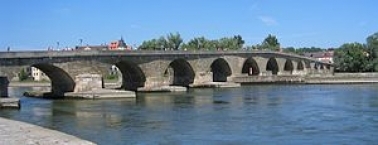
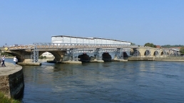
The Stone Bridge (Steinerne Brücke) in Regensburg ![]() , Germany, is a 12th-century bridge across the Danube linking the Old Town with Stadtamhof. For more than 800 years, until the 1930s, it was the city's only bridge across the river. It is a masterwork of medieval construction and an emblem of the city.
, Germany, is a 12th-century bridge across the Danube linking the Old Town with Stadtamhof. For more than 800 years, until the 1930s, it was the city's only bridge across the river. It is a masterwork of medieval construction and an emblem of the city.
Charlemagne had a wooden bridge built at Regensburg, approximately 100 metres (330 ft) east of the present bridge, but it was inadequate for the traffic and vulnerable to floods, so it was decided to replace it with a stone bridge.
The Stone Bridge was built in only eleven years, probably in 1135–46. Louis VII of France and his army used it to cross the Danube on their way to the Second Crusade. It served as a model for other stone bridges built in Europe in the 12th and 13th centuries: the Elbe bridge in Dresden, London Bridge across the Thames, the Pont d'Avignon across the Rhône and the Judith Bridge (predecessor of the Charles Bridge) across the Vltava in Prague. It remained the only bridge across the Danube at Regensburg for about 800 years, until the construction of the Nibelungen Bridge ![]() . For centuries it was the only bridge over the river between Ulm and Vienna , making Regensburg into a major centre of trade and government.
. For centuries it was the only bridge over the river between Ulm and Vienna , making Regensburg into a major centre of trade and government.
The bridge originally had its own administration, using a seal depicting it, the oldest example of which dates to 1307; tolls were used for its upkeep.
Construction and modifications
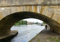
The Stone Bridge is an arch bridge with 16 arches. At the south end, the first arch and first pier were incorporated into the Regensburg Salt Store when it was built in 1616–20, but remain in place under the approach road to the bridge. An archaeological investigation was performed in 2009, and revealed fire damage during the Middle Ages. The bridge was originally 336 metres (1,102 ft) long; the building in of the first pier reduced it to 308.7 metres (1,013 ft). The southern, Old Town end of the bridge is half a metre lower than the northern, Stadtamhof end, and the bridge bends slightly because of the course of the river at that point.
Information about copyright | |
|---|---|
Rights characteristic / license | by-sa: CREATIVE COMMONS Attribution-ShareAlike |
Link to the description of the license | |
Input taken over from: |
Stone Bridge (Regensburg). (2014, August 29). In Wikipedia, The Free Encyclopedia. Retrieved 06:19, September 8, 2014, from http://en.wikipedia.org/w/index.php?title=Stone_Bridge_(Regensburg)&oldid=623282712 |
taken over / edited on | 08 Sep 2014 - 06 Jul 2021
|
taken over / edited by |
|
Hours of opening
April to October: daily from 10am to 7 pm
(November to March closed)
0 km
1,1 km
346 m
0 km
2,2 km
332 m
0 km
0,9 km
331 m
0 km
3,0 km
352 m
![]()