
Cycle Route Ticino
No. of cycle route PCIR1
Actions
![]()
Please wait - map data are loading
Added on 15 Oct 2013,
last edited by biroto-Redaktion on 24 Oct 2023
Actions
Cycle route metrics
Total distance in km
147
Information about rights to the gps-track data | |
|---|---|
Rights owner | OpenStreetMap and Contributors + biroto-Redaktion (biroto.eu) |
Rights characteristic / license | Contains information from OpenStreetMap, which is made available here under the Open Database License(ODbL) |
Link to the description of the license | |
GPX file taken from | |
GPX file uploaded | by biroto-Redaktion on 24 Oct 2023
|
Track points in total
2.516
Track points per km (avg)
17
Start/endpoint
Start location
Luino, 25, IT (200 m NHN)
End location
Pavia, 25, IT (88 m NHN)
Beds4Cyclists, worth visiting and infrastructure
Name and address
Latitude / Longitude
Phone
Fax
Mobile
Type of accommodation
Rating for cyclists
Route km
Dist. to route
Elevation
97 km
4,2 km
141 m
108 km
0,4 km
108 m
145 km
2,2 km
85 m
147 km
0,1 km
50 m
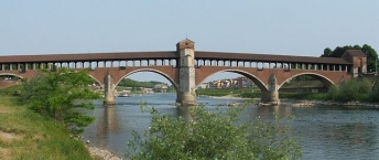
Information about copyright | |
|---|---|
Rights owner | |
Rights characteristic / license | by-sa: CREATIVE COMMONS Attribution-ShareAlike |
Link to the description of the license | |
Image taken over from | it.wikipedia.org/wiki/File:Pavia_ponte_coperto_sul_Ticino.jpg |
Image has been uploaded | by biroto-Redaktion on 04 Mar 2014
|
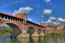
Information about copyright | |
|---|---|
Rights owner | |
Rights characteristic / license | by-sa: CREATIVE COMMONS Attribution-ShareAlike |
Link to the description of the license | |
Image taken over from | commons.wikimedia.org/wiki/File:Ponte_coperto_fi_pavia,_lato_est.jpg |
Image has been uploaded | by biroto-Redaktion on 04 Mar 2014
|
The Ponte Coperto "covered bridge" (also known as the Ponte Vecchio "Old Bridge") is a brick and stone arch bridge over the Ticino River ![]() in Pavia.
in Pavia.
The previous bridge, dating from 1354 (itself a replacement for a Roman construction), was heavily damaged by Allied action in 1945. A debate on whether to fix or replace the bridge ended when the bridge partially collapsed in 1947, requiring new construction, which began in 1949. The new bridge is based on the previous one, which had seven arches to the current bridge's five.
Information about copyright | |
|---|---|
Rights characteristic / license | by-sa: CREATIVE COMMONS Attribution-ShareAlike |
Link to the description of the license | |
Input taken over from: |
Wikipedia contributors, 'Ponte Coperto', Wikipedia, The Free Encyclopedia, 26 April 2013, 19:30 UTC, <http://en.wikipedia.org/w/index.php?title=Ponte_Coperto&oldid=552319354> [accessed 4 March 2014] |
taken over / edited on | 04 Mar 2014
|
taken over / edited by |
|
147 km
0,4 km
75 m
![]()