
Cycle Route Coastroute Trondheim-Bergen
No. of cycle route 1B
Actions
![]()
Please wait - map data are loading
Added on 27 Dec 2011,
last edited by biroto-Redaktion on 15 Nov 2023
Actions
Cycle route metrics
Total distance in km
833
Information about rights to the gps-track data | |
|---|---|
Rights owner | OpenStreetMap and Contributors + biroto-Redaktion (biroto.eu) |
Rights characteristic / license | Contains information from OpenStreetMap, which is made available here under the Open Database License(ODbL) |
Link to the description of the license | |
GPX file taken from | |
GPX file uploaded | by biroto-Redaktion on 03 Nov 2023
|
Track points in total
17.935
Track points per km (avg)
18
Start/endpoint
Start location
Trondheim, NO (16 m NHN)
End location
Bergen, NO (18 m NHN)
Beds4Cyclists, worth visiting and infrastructure
Name and address
Latitude / Longitude
Phone
Fax
Mobile
Type of accommodation
Rating for cyclists
Route km
Dist. to route
Elevation
0 km
1,6 km
11 m
Hours of opening
Monday - Saturday: 09:00 - 18:00
0 km
1,8 km
16 m
0 km
1,8 km
0 km
1,4 km
10 m
1 km
1,3 km
22 m
Information about copyright | |
|---|---|
Rights owner | |
Rights characteristic / license | by-sa: CREATIVE COMMONS Attribution-ShareAlike |
Link to the description of the license | |
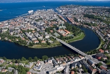
Image taken over from | https://commons.wikimedia.org/wiki/File:Overview_of_Trondheim_2008_03.jpg |
Image has been uploaded | by biroto-Redaktion on 02 Jan 2019
|
Information about copyright | |
|---|---|
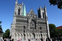
Rights owner | https://commons.wikimedia.org/w/index.php?title=User:Martijnvdbraak |
Rights characteristic / license | by-sa: CREATIVE COMMONS Attribution-ShareAlike |
Link to the description of the license | |
Image taken over from | |
Image has been uploaded | by biroto-Redaktion on 02 Jan 2019
|
Information about copyright | |
|---|---|
Rights owner | |
Rights characteristic / license | cc0: Public Domain no Rights reserved |
Link to the description of the license | |
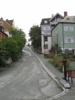
Image taken over from | https://commons.wikimedia.org/wiki/File:TrondheimTrampeHill.jpg |
Image has been uploaded | by biroto-Redaktion on 02 Jan 2019
|
Information about copyright | |
|---|---|
Rights owner | |
Rights characteristic / license | by-sa: CREATIVE COMMONS Attribution-ShareAlike |
Link to the description of the license | |
Image taken over from | |
Image has been uploaded | by biroto-Redaktion on 02 Jan 2019
|
Trondheim, formerly Trondhjem or Nidaros, is an old city in central Norway. It is a key city in Norway, its skyline dominated by the lovely cathedral and its city life dominated by the university. Central Trondheim is beautifully located inside a large river bend where the river meets the wide Trondheimsfjord.
Understand
Trondheim is the oldest of Norway's major cities, and its rich heritage can still be traced in and around the city centre. It's a scenic city, located on the southern shore of the Trondheimsfjord, which is the third longest in Norway, and so wide that it is almost like a sea. Even if the size is modest, there is a lot going on in Trondheim. Music, arts, culture, alternative politics, nightlife and student life - all combines into making Trondheim one of the most exciting city centres of Northern Europe.
The city centre is roughly the area inside the meandering Nidelva. The marvellous Nidaros Cathedral, the second-largest church of Northern Europe and the only real Gothic cathedral in Norway, towers over the city centre. Legend has that it was built over the grave of St Olav, Norway's patron saint and "eternal king". Regarded as a national treasure, it has been the site of coronation of Norway's kings. The cathedral has been under restoration since 1860 and as the only state church in Norway, obtains grants directly from the parliament through the state budget.
The Norwegian University of Science and Technology (NTNU) is the main technical university of Norway and contributes greatly to the city's social profile and economy. Out of Trondheim's 160,000 inhabitants, 25,000 are students at the NTNU.
History
The city celebrated its 1000th anniversary in 1997 but contrary to popular belief Trondheim was not so much of a centre for the Vikings as it was founded at the end of the Viking Age. However, it was the religious centre of northern Europe during the Middle Ages and a vital hub for North Atlantic trade, giving it plenty of characteristic mansions and harbour houses. From 1152 until the Protestant Reformation, Trondheim (or Nidaros as it was called) was the seat of the Archbishop of Norway (present-day Norway plus Iceland, Orkney and Shetland). The ancient name Nidaros reads "mouth of river Nid". For centuries, Trondheim was the northernmost mercantile city in Europe, giving it a special "edge-of-the-world" feeling. This also resulted in a more outgoing international culture than many other Scandinavian cities at the time. The inhabitants like to call their city the historical, religious, and technological capital of Norway.
See
Architecture
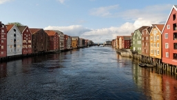
Stay close to the ⊙Nidelva if you want to see the real pearl of the city. The sunsets can be magnificent, especially in summer, and the city is so far north that the first hints of Arctic blue sky are seen. Summer days seem to last forever, although for a real midnight sun, you have to travel further north. The river is nicely experienced in the park ⊙Marinen just behind the cathedral. There are a lot of wooden mansions in and around the city centre. ⊙Stiftsgaarden, the King's local residence, is the biggest together with the Singsaker summer hotel, but the small, wooden houses in parts of the city like ⊙Baklandet, ⊙Hospitalsløkkan, ⊙Ila and ⊙Ilsvikøra are even more picturesque. Wooden harbour buildings can be seen along Kjøpmannsgata, Fjordgata and Sandgata. The best view is from the ⊙Old Town Bridge across Nidelva river, leading from close to the cathedral to Bakklandet.
- ⊙Nidaros Cathedral (Nidarosdomen). Jun–Aug: M–F 09:00–18:00, Sa 09:00–14:00, Su 09:00–17:00; Sep–Dec: M–Sa 09:00–14:00, Su 09:00–16:00. This is the biggest church of Northern Europe, the only major Gothic cathedral in Norway and the pride of the city. Towering over the city centre at its southern edge, the majestic cathedral is the defining feature of Trondheim. Nidarosdomen is also Norway's national cathedral. It was erected over what was believed to be St. Olav's grave and it became a major pilgrimage site in Northern Europe. Next door is the Archbishop's Palace, which was partly burnt down in the 1980s and has been heavily restored. Cathedral: kr 90, Archbishop's Palace museum: kr 90, Crown Regalia: kr 90, Combined ticket (cathedral, palace, crown): kr 180, Tower: kr 40.

- ⊙Vår Frue Church. The "Our Lady's Church" also dates from the Middle Ages but was partially rebuilt after a fire in 1708. Almost next to the central square, it's one of Trondheim's landmarks and has an interesting interior.
- ⊙Torvet. The central square is the hub of Trondheim. Surrounded by shops, cafés and services, it's used for events, meetings, and a flea market on Saturdays.
- ⊙Tyholt tower (Tyholttårnet), Otto Nielsens vei 4 (bus 20,60 to Tyholttårnet/Otto Nielsens veg). TV-tower with a rotating top restaurant: Egon Tårnet.
- ⊙Kristiansten Fortress (Kristiansten festning). Small fortress on a hill overlooking the centre. Have a walk in the area for good views of Trondheim. If you can't be bothered with the hills, get bus 63 to Ankersgata, or rent a bike and use the bike lift!
- ⊙Munkholmen. The ancient fortress island, ideal for swimming, sunbathing or a peek at the old monastery. The boat out there operates in the summer (middle of May to early September). The rest of the year you just get to look at it from land, for instance from the Kristiansten Fortress. Guided tour: kr 40, payment by cash only.
- ⊙Dora 1. The German submarine base for the 13th flotilla during the German occupation of Norway 1940 - 1945. Today the bunker houses many archives, among them the city archives, university and state archives.
Museums
- ⊙The Archbishop's Palace Museum, Kongsgårdsgata. Original sculptures from Nidaros Cathedral and archaeological finds from its dramatic history. ☎ +47 73 890800. Open: Tu-Fr 11-14, Sa 11-15, Su 12-16, adults: 80 NOK, student/senior: 50 NOK, Tower ticket (summer): 40 NOK.
- ⊙Stiftsgaarden, Munkegata 23, the Royal Residence. ☎ +47 73 808950, Open: 1st of June - 18th of August 2019, Mo-Sa guided tours 10 a.m, 11 a.m, 12 p.m, 1 p.m, 2 p.m, 3 p.m, Su guided tours 12 p.m, 1 p.m, 2 p.m, 3 p.m, adults: 110 NOK, students: 80 NOK
- ⊙Sverresborg Trøndelag Folk Museum, Sverresborg Alle 13 (bus 18 to Trøndelag Folkemuseum), ☎ +47 73 890100. daily 10:00–17:00 (reduced hours in low season). At Sverresborg, with lots of old houses depicting lifestyle in old days. In a very beautiful park area overlooking the city, and truly worth a visit! Activities for children on Sundays. Eat at the nice inhouse-cafe, or at the next-door "Tavern" dating from the 18th century. Adults: kr 125 (kr 70 in low season).
- ⊙Vitensentret (Trondheim Science Museum), Kongens gate 1, ☎ +47 73 596123. 10:00-16:00 (winter), 10:00-17:00 (summer). A center for popularizing science, has lots of exhibits many of them are interactive. Also has a gift store. Opens 1 hour later on Saturday/Sunday. kr 90 (adult).
Other
- ⊙Trampe, Brubakken (just across the old town bridge). The world's first bike lift. Free.
- ⊙Trondheim folkebibliotek, Kongens gate 2. The city library is built upon the ruins of a medieval church and some archeological objects are on display. The building itself, which was built as the city hall in the 19th century, is semi-interesting. Being a library you can of course also borrow and read books there and it's the site of literature related events.
Eat
Trondheim has food spots to suit every taste, though remember that eating out is generally very expensive, just like elsewhere in Norway.
Budget
- ⊙Tavern, Sverresborg Alle 11 (bus 8 to Trøndelag Folkemuseum). Hardly a bargain at normal times, this old 18th century-inn dishes up all-you-can-eat klubb (potato dumplings with bacon and brown cheese sauce) every Tuesday for well below kr 100. Well worth it, for a taste of real Norwegian peasant cuisine. Be prepared to roll down the hills towards the city afterwards, this is filling food!
Mid-range
- ⊙Bakklandet Skydsstation, Øvre Bakklandet 33. The place to find old Norwegian standards, such as kjøttkaker (meat cakes) and baccalao (dried, salted cod in a tomato sauce), in what must be the city's most charming and least right-angled house. Doubles as a cosy cafe-cum-pub at night. The restaurant is quite small with around ten small tables, so you might want to come a bit outside regular dining times to get a seat.
Information about copyright | |
|---|---|
Rights characteristic / license | by-sa: CREATIVE COMMONS Attribution-ShareAlike |
Link to the description of the license | |
Input taken over from: |
Wikivoyage contributors, 'Trondheim', Wikivoyage, The FREE worldwide travel guide that anyone can edit, 12 November 2018, 18:56 UTC, <https://en.wikivoyage.org/w/index.php?title=Trondheim&oldid=3647980> [accessed 2 January 2019] |
taken over / edited on | 02 Jan 2019
|
taken over / edited by |
|
![]()