
Cycle Route Nacional N2
No. of cycle route N2
Actions
![]()
Please wait - map data are loading
Added on 29 Dec 2020,
last edited by biroto-Redaktion on 29 Dec 2020
Actions
Cycle route metrics
Total distance in km
714
Information about rights to the gps-track data | |
|---|---|
Rights owner | OpenStreetMap and Contributors + biroto-Redaktion (biroto.eu) |
Rights characteristic / license | Contains information from OpenStreetMap, which is made available here under the Open Database License(ODbL) |
Link to the description of the license | |
GPX file taken from | |
GPX file uploaded | by biroto-Redaktion on 29 Dec 2020
|
Track points in total
10.005
Track points per km (avg)
14
Start/endpoint
Start location
Madalena e Samaiões, North, PT (352 m NHN)
End location
Faro, Algarve, PT (35 m NHN)
Character
On the national road N2 from the city of Chaves in the north near the Spanish border to the other end in the city of Faro in the Algarve.
This is the longest Portuguese road with a length of about 739 kilometers.
Information about copyright | |
|---|---|
Rights characteristic / license | by-sa: CREATIVE COMMONS Attribution-ShareAlike |
Link to the description of the license | |
taken over / edited on | 29 Dec 2020
|
taken over / edited by |
|
Beds4Cyclists, worth visiting and infrastructure
Name and address
Latitude / Longitude
Phone
Fax
Mobile
Type of accommodation
Rating for cyclists
Route km
Dist. to route
Elevation
80 km
0,0 km
238 m
171 km
0,5 km
480 m
698 km
0,5 km
250 m
714 km
0,8 km
22 m
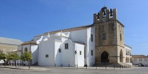
Information about copyright | |
|---|---|
Rights owner | |
Rights characteristic / license | by-sa: CREATIVE COMMONS Attribution-ShareAlike |
Link to the description of the license | |
Image taken over from | https://commons.wikimedia.org/wiki/File:Faro-Kathedrale-1-bis.jpg |
Image has been uploaded | by biroto-Redaktion on 02 Aug 2016
|
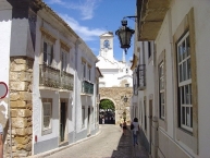
Information about copyright | |
|---|---|
Rights owner | |
Rights characteristic / license | by-sa: CREATIVE COMMONS Attribution-ShareAlike |
Link to the description of the license | |
Image taken over from | https://commons.wikimedia.org/wiki/File:Arco_da_vila_2016_2.jpg |
Image has been uploaded | by biroto-Redaktion on 02 Aug 2016
|
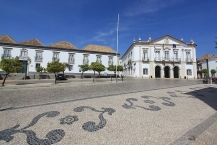
Information about copyright | |
|---|---|
Rights owner | |
Rights characteristic / license | by-sa: CREATIVE COMMONS Attribution-ShareAlike |
Link to the description of the license | |
Image taken over from | https://commons.wikimedia.org/wiki/File:Faro_Cidade_Velha_2.JPG |
Image has been uploaded | by biroto-Redaktion on 02 Aug 2016
|
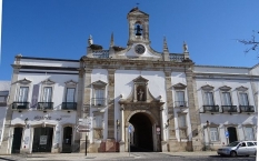
Information about copyright | |
|---|---|
Rights owner | |
Rights characteristic / license | by-sa: CREATIVE COMMONS Attribution-ShareAlike |
Link to the description of the license | |
Image taken over from | https://commons.wikimedia.org/wiki/File:Faro-Bischofspalast-Rathaus.jpg |
Image has been uploaded | by biroto-Redaktion on 02 Aug 2016
|
Faro (Portuguese pronunciation: [ˈfaɾu]) is a municipality, southernmost city and seat of the district of the same name, in the Algarve region of southern Portugal. With a population of 64,560 inhabitants in 2011 (with 50,000 inhabitants in the city proper), the municipality covers an area of approximately 202.57 square kilometres (78.21 square miles).
Information about copyright | |
|---|---|
Rights characteristic / license | by-sa: CREATIVE COMMONS Attribution-ShareAlike |
Link to the description of the license | |
Input taken over from: |
Wikipedia contributors, 'Faro, Portugal', Wikipedia, The Free Encyclopedia, 25 July 2016, 10:47 UTC, <https://en.wikipedia.org/w/index.php?title=Faro,_Portugal&oldid=731438332> [accessed 2 August 2016] |
taken over / edited on | 02 Aug 2016
|
taken over / edited by |
|
714 km
0,9 km
10 m