
Cycle Tour Radtour Molln nach Passau 2018
Planned tour
Actions
![]()
Please wait - map data are loading
Added on 06 Mar 2018,
last edited by vaz21044 on 06 Mar 2018
Actions
Cycle route metrics
planned
ridden
Total distance in km
162
0
Cumulative elevation gain in m
1.977
0
Avg. slope uphill in %
1,22
-
Cumulative elevation loss in m
2.154
0
Information about rights to the gps-track data | |
|---|---|
Rights owner | |
Rights characteristic / license | cc0: Public Domain no Rights reserved |
Link to the description of the license | |
GPX file uploaded | by vaz21044 on 06 Mar 2018
|
Track points in total
2.462
0
Track points per km (avg)
15
0
Start/endpoint
Start location
Molln, Oberösterreich, AT (471 m NHN)
End location
Passau, Bayern, DE (294 m NHN)
Beds4Cyclists, worth visiting and infrastructure
Name and address
Latitude / Longitude
Phone
Fax
Mobile
Type of accommodation
Rating for cyclists
Route km
Dist. to route
Elevation
72 km
4,8 km
258 m
76 km
1,7 km
268 m
Information about copyright | |
|---|---|
Rights owner | |
Rights characteristic / license | by-sa: CREATIVE COMMONS Attribution-ShareAlike |
Link to the description of the license | |
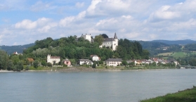
Image taken over from | https://commons.wikimedia.org/wiki/File:Ottensheim_castle.jpg |
Image has been uploaded | by biroto-Redaktion on 12 Jan 2015
|
Information about copyright | |
|---|---|
Rights owner | |
Rights characteristic / license | by-sa: CREATIVE COMMONS Attribution-ShareAlike |
Link to the description of the license | |
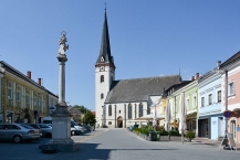
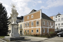
Image taken over from | https://commons.wikimedia.org/wiki/File:Ottensheim_Marktplatz_mit_Kirche_und_Mariensäule.jpg |
Image has been uploaded | by biroto-Redaktion on 12 Jan 2015
|
Information about copyright | |
|---|---|
Rights owner | https://de.wikipedia.org/wiki/Benutzer:Otto_Normalverbraucher |
Rights characteristic / license | by-sa: CREATIVE COMMONS Attribution-ShareAlike |
Link to the description of the license | |
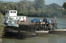
Image taken over from | https://commons.wikimedia.org/wiki/File:Faehre_Ottensheim.jpg |
Image has been uploaded | by biroto-Redaktion on 12 Jan 2015
|
Ottensheim ist eine Marktgemeinde in Oberösterreich im Bezirk Urfahr-Umgebung im oberen Mühlviertel mit 4469 Einwohnern (2014). Die Gemeinde liegt im Gerichtsbezirk Urfahr.
Die Gemeinde als einst bedeutsamer Handelsknoten an der Donau ist der drittälteste Markt Oberösterreichs und verfügt über einen historischen Marktkern mit Gebäuden aus den vergangenen Jahrhunderten.
Sehenswürdigkeiten
Bauwerke
- Schloss Ottensheim

Das Schloss steht auf einem Felsrücken, der nach Süden zur Donau steil abfällt. Der Hof besteht aus zwei Terrassen und wird nach Osten vom Turmflügel abgeschlossen. Der viereckige Turm wurde ursprünglich zur Gänze aus Bruchsteinen erbaut. Beim Umbau der Burg wurde der Turm bis zum ersten Stock abgetragen und dann mit Ziegeln neu errichtet. Im ersten Stock ist die Kapelle untergebracht. Im Norden der Anlage befindet sich ein weitläufiger Park. Das Schloss befindet sich in Privatbesitz. - Pfarrkirche: gotisch, 1467 Baubeginn der heutigen Pfarrkirche
- Marktplatz
- Ottensheimer Drahtseilbrücke: Die Drahtseilbrücke bietet eine Verbindung über die Donau
Information about copyright | |
|---|---|
Rights characteristic / license | by-sa: CREATIVE COMMONS Attribution-ShareAlike |
Link to the description of the license | |
Input taken over from: |
|
taken over / edited on | 12 Jan 2015
|
taken over / edited by |
|
76 km
1,6 km
260 m
76 km
1,6 km
263 m
94 km
0,1 km
267 m
Information about copyright | |
|---|---|
Rights owner | |
Rights characteristic / license | by-sa: CREATIVE COMMONS Attribution-ShareAlike |
Link to the description of the license | |
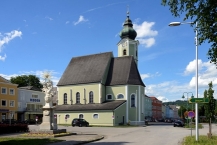
Image taken over from | https://commons.wikimedia.org/wiki/File:Pfarrkirche_Aschach_an_der_Donau.JPG |
Image has been uploaded | by biroto-Redaktion on 12 Jan 2015
|
Information about copyright | |
|---|---|
Rights owner | |
Rights characteristic / license | by-sa: CREATIVE COMMONS Attribution-ShareAlike |
Link to the description of the license | |
Image taken over from | https://commons.wikimedia.org/wiki/File:Aschach_Donau_Sindlhuberhaus.JPG |
Image has been uploaded | by biroto-Redaktion on 12 Jan 2015
|
Information about copyright | |
|---|---|
Rights owner | https://commons.wikimedia.org/w/index.php?title=User:Schloss_Aschach |
Rights characteristic / license | by-sa: CREATIVE COMMONS Attribution-ShareAlike |
Link to the description of the license | |
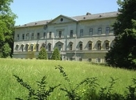
Image taken over from | https://commons.wikimedia.org/wiki/File:Schloss_Südseite.jpg |
Image has been uploaded | by biroto-Redaktion on 12 Jan 2015
|
Aschach an der Donau is a municipality in the district Eferding in Upper Austria.
Landmarks
- Aschach has a historic center with town houses dating from the Middle Ages, with beautiful facades and courtyards from the Gothic, Baroque and Renaissance.
- Parish Church with the Danube Cross: around 1490 follows the Late-Gothic succeeding building of an originally in 1371 first mentioned church on records. The high altar is crowned by the healing powers of the revered Danube cross. It was brought ashore in 1693 by two sailors in a flood. The sickly restorer of the cross was healed during his work. 1784, Aschach was separated by a government decree of Emperor Joseph II from the mother-church Hartkirchen and elevated to an independent parish. 1976, the church was renovated and expanded, designed by Clemens Holzmeister.
- Old Town Hall
- Schloss Aschach: The manor house is the former seat of the Counts of Harrach. The main wing of the manor house from the 16th Century has arcades in the courtyard on all three floors. The east wing was built in 1709 by Johann Lucas von Hildebrandt, as well as the altar in the chapel. The castle is privately owned.
- Donaukraftwerk Aschach : The hydro power plant was built 1959-1964 and was once Europe's largest hydro power plant.
- Schopper and Fishery museum. The museum presents the history of the Market Aschach in connection with the shipbuilding - and shipping tradition on the Upper Danube. The Schopper museum presents the historic craft of shipbuilding and also the social and cultural environment of these craftsmen's guilds. In addition, the last original Zehner Trauner is displayed. The Fisheries Museum shows the development of commercial and recreational fishery in Upper Austria with special reference to the upper Danube.
Information about copyright | |
|---|---|
Rights characteristic / license | by-sa: CREATIVE COMMONS Attribution-ShareAlike |
Link to the description of the license | |
Input taken over from: |
Wikipedia contributors, 'Aschach an der Donau', Wikipedia, The Free Encyclopedia, 29 January 2014, 20:26 UTC, <http://en.wikipedia.org/w/index.php?title=Aschach_an_der_Donau&oldid=593008792> [accessed 12 January 2015] |
taken over / edited on | 12 Jan 2015
|
taken over / edited by |
|
![]()